Forecast for the Skyline Area Mountains

Brett Kobernik
Issued by Brett Kobernik for
Tuesday, March 15, 2022
DANGEROUS AVALANCHE CONDITIONS CONTINUE!!
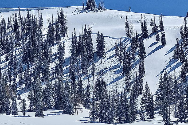
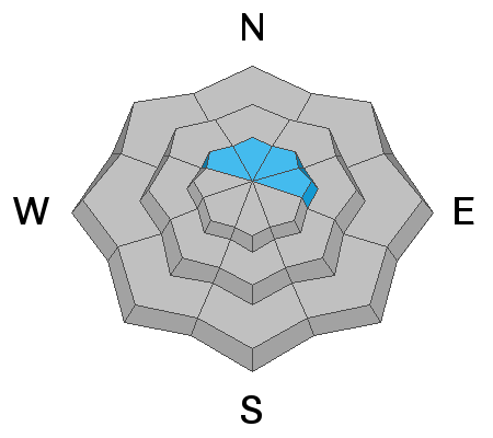
The avalanche danger is CONSIDERABLE on upper elevation northwest, north, northeast, and east facing slopes.
Avalanches can still be triggered from a distance so avoid being below steep slopes as well as avoid being on them.
If you avoid the terrain described above, the avalanche danger is much lower.
Low
Moderate
Considerable
High
Extreme
Learn how to read the forecast here
Weather and Snow
Current Conditions
Riding conditions remained decent on Monday with a small dusting of new snow. You'll find melt-freeze crusts on sunny facing slopes. The wind has been calm to light. It increased in speed along the highest terrain from the southwest but remains pretty light down off the ridges. Overnight temperatures were in the mid 20s.
Mountain Weather
We have a nice start for the day with sunny skies. Clouds will start to move in this afternoon ahead of the next system that might deliver a trace to a few inches of snow tonight. Temperatures will get up around 40˚F. It looks like southwest wind may increase a bit this afternoon but it doesn't look all that strong.
Recent Avalanches
Snowmobilers remotely triggered another deep avalanche on Monday. They triggered it from a long distance away while they were playing in flat terrain. Photo below - North Fork of Pleasant Creek, Brian Seeley:
The activity from the weekend was pretty impressive. Below is a video that recaps a bunch of the avalanches.
Ad
Avalanche Problem #1
Persistent Weak Layer
Type
Location
Likelihood
Size
Description
Yesterday's remotely triggered avalanche clearly demonstrates that the snowpack remains unstable. If we are still triggering avalanches from a distance 5 days after the last storm, we have problems. Do not let your guard down. We continue to hear about close calls from many of our regions. The buried Persistent Weak Layer is still very active. Someone's luck is bound to runout, don't let it be you. Continue to avoid the steep upper elevation northwest, north, northeast, and east facing terrain. Avoid being directly below steep slopes since we can still trigger avalanches from a distance below.
General Announcements
This forecast is from the U.S.D.A. Forest Service, which is solely responsible for its content. This forecast describes general avalanche conditions and local variations always occur.