Forecast for the Skyline Area Mountains

Brett Kobernik
Issued by Brett Kobernik for
Sunday, March 12, 2023
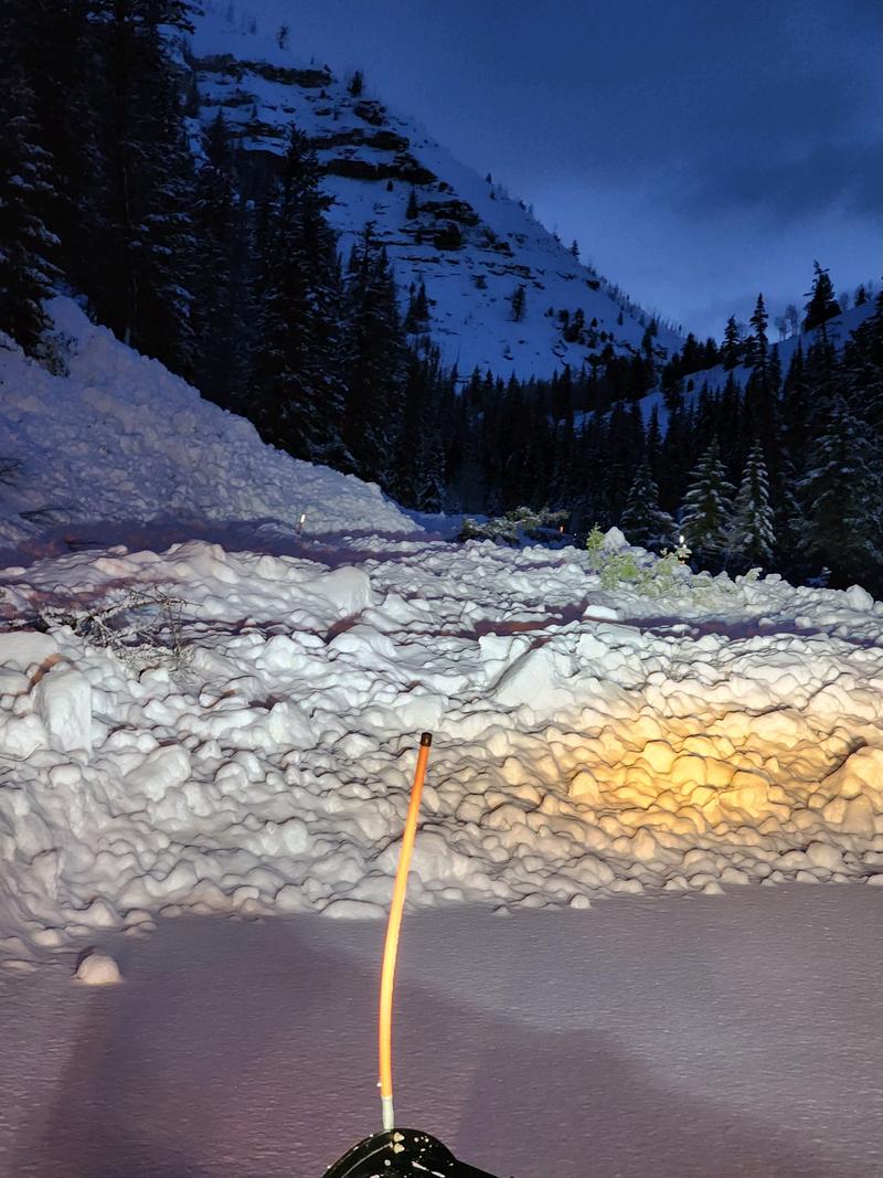
Avalanche conditions have stabilized somewhat. The overall danger rating is MODERATE.
Human triggered avalanches are possible.
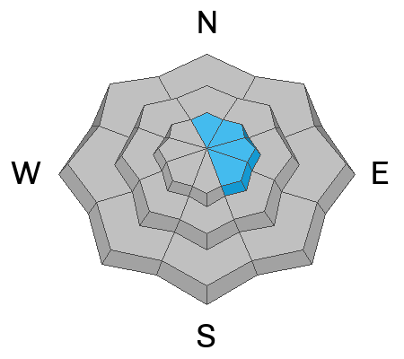
The most likely places to trigger an avalanche are:
  1. High elevation steep slopes near the ridgelines on more east facing terrain.
  2. Lower elevation very steep slopes where the snowpack is wet, punchy and shallow.
Low
Moderate
Considerable
High
Extreme
Learn how to read the forecast here
Special Announcements
HUNTINGTON CANYON REMAINS CLOSED DUE TO AVALANCHES THAT HAVE CROSSED THE ROAD AND BLOCKED IT.
Weather and Snow
Current Conditions: The new snow was damp up to around 9300' in elevation on Saturday. Above that, riding conditions are quite good with spongy, dense cold powder on the surface. Wind from the west has been light to moderate in speed over the last 24 hours. Only a small amount of drifting snow has occurred. Temperatures were 25˚ to 30˚F on Saturday. They didn't cool much overnight. A few inches of new snow has accumulated over the last 24 hours. We have light snow as of 6am this morning.

Mountain Weather: It'll be another mostly cloudy day today with the chance of snow. A few inches of snow is possible. Wind will be moderate in speed from the west. Temperatures should get into the low 30s. There will be chances for light snow Monday and Tuesday with a more significant storm moving through Wednesday.
Ad
Avalanche Problem #1
New Snow
Type
Location
Likelihood
Size
Description
The new snow is stabilizing and is not all that sensitive to people at this point. However, I would still use caution today along the high east facing ridgelines. Recent deposits of wind drifted snow may still crack out on a person today in this terrain. Most of these drifts will be hidden by new snow since there was very little wind with the last few inches of snow.
Avalanche Problem #2
Wet Snow
Type
Location
Likelihood
Size
Description
The problem down in the lower elevations is the new snow is wet and so are the underlying layers now as well. This makes for an unstable structure. AVOID ALL STEEP LOWER ELEVATION TERRAIN ESPECIALLY GULLIES AND RAVINES.
General Announcements
This forecast is from the U.S.D.A. Forest Service, which is solely responsible for its content. This forecast describes general avalanche conditions and local variations always occur.