Forecast for the Skyline Area Mountains

Brett Kobernik
Issued by Brett Kobernik for
Monday, February 6, 2023
The overall danger rating is MODERATE today.
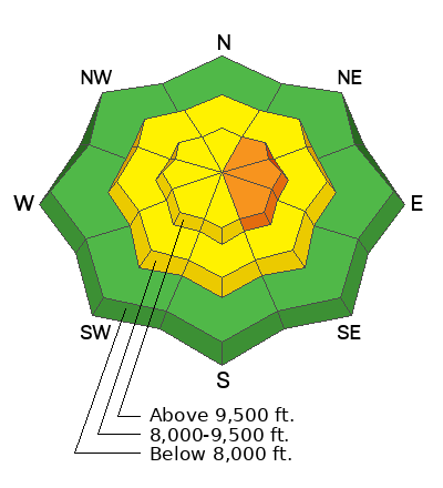
There is a CONSIDERABLE danger rating on the upper elevation northeast through southeast facing slopes. Human triggered avalanches are likely in this terrain.
The wind has created fresh drifts and slabs which are cause for concern today.
Low
Moderate
Considerable
High
Extreme
Learn how to read the forecast here
Weather and Snow
Current Conditions: The Skyline picked up 6 inches of new snow with the passage of a cold front late Sunday afternoon. The wind has been from the west with moderate to strong speeds. The wind has gotten down into the canyons and stirred things up a bit. Temperatures have been cooling and are around 15˚F.
Mountain Weather: It looks like the mountains will stay socked in with clouds today and periods of light snowfall. We could see a few more inches of accumulation by Tuesday morning. Wind will be moderate to strong from the northwest this morning and decrease in speed later this afternoon. Temperatures won't get much warmer today, staying in the mid to upper teens. The next few days look nice with mostly clear skies. There's a minor weather disturbance that will move through Wednesday night but it won't produce much snow.
Ad
Avalanche Problem #1
Wind Drifted Snow
Type
Location
Likelihood
Size
Description
There are a few things going on that cause me some concern today.
  1. The old snow surface became slightly weak (small grained sugary loose faceted snow) during the five days of clear, cold weather last week. It didn't seem super alarming to me (not all that loose) but enough so to take note of it.
  2. We added 6 inches of new snow on top of the older slightly weak surface snow. These first two factors are not a huge concern on their own.
  3. Wind. This is the kicker. The wind has no doubt drifted the new snow into slabs. These alone could be sensitive but will be even more sensitive in areas where they've formed over the older sugary surface snow.
The problem will be most pronounced on the more easterly facing slopes since the wind has been from the west and has been transporting snow onto those aspects. However, watch for fresh pillows and slabs on any aspect. See THIS EXCELENT BACKCOUNTRY OBSERVATION from Chris Magerl describing the new snow and wind on Sunday.
Look for any new avalanche activity. Watch for cracking within the new snow. These are both telltale signs that things are sensitive. Perform a few STABILITY TESTS on the upper layers of the snowpack. Hit small TEST SLOPES to see if they crack out. If the new wind drifted snow is active, it should show it's cards easily.
General Announcements
This forecast is from the U.S.D.A. Forest Service, which is solely responsible for its content. This forecast describes general avalanche conditions and local variations always occur.