Forecast for the Skyline Area Mountains

Brett Kobernik
Issued by Brett Kobernik for
Sunday, February 5, 2023
The overall danger rating is LOW today.
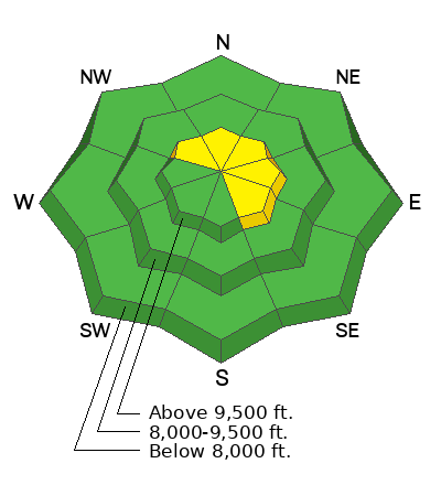
Wind drifted snow will create a MODERATE danger rating on upper elevations steep northwest through southeast facing slopes.
Small human triggered avalanches are possible along the higher ridges where fresh drifts are forming.
Low
Moderate
Considerable
High
Extreme
Learn how to read the forecast here
Weather and Snow
Current Conditions: Temperatures remain mild along the higher terrain with readings around 30. It's colder down in the canyon bottoms. The wind is from the southwest and is increasing in speed. You'll find various wind crusts in the higher terrain and melt-freeze crusts on the sunny facing slopes. There is plenty of soft settled powder around still in protected terrain.
Mountain Weather: We'll have increasing clouds and increasing wind from the south today. High temperatures will be around 30 and cooling this afternoon as a storm rolls in. We should see a decent shot of snow as the cold front moves through this afternoon. The storm should linger through Monday with additional periods of snow. I'm not really confident in snow totals but I'm thinking 4 to 9 inches by Monday evening.
Ad
Avalanche Problem #1
Wind Drifted Snow
Type
Location
Likelihood
Size
Description
Wind drifted snow along the higher ridges and peaks is your main concern today. Fresh drifts of wind deposited snow will probably be sensitive to people today. These pockets won't be huge but could knock you around if you trigger one. If you avoid areas with freshly drifted snow, you'll avoid any avalanche danger today.
General Announcements
This forecast is from the U.S.D.A. Forest Service, which is solely responsible for its content. This forecast describes general avalanche conditions and local variations always occur.