Forecast for the Skyline Area Mountains

Brett Kobernik
Issued by Brett Kobernik for
Tuesday, February 27, 2024
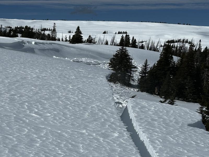
The avalanche danger rating for the Skyline is CONSIDERABLE today.
Strong wind over the last 24 hours coupled with new snow has created fresh drifts and slabs of snow that are likely to release if provoked.
Natural avalanches are possible today as strong wind is forecast to continue.
Avoid steep slopes and any steep terrain features where the wind has deposited snow.
Low
Moderate
Considerable
High
Extreme
Learn how to read the forecast here
Weather and Snow
Current Conditions: Strong wind from the southwest has blasted the Skyline. Gusts reached 70mph at Monument Peak. There was a gust to 45mph along State Road 31 at the top of Fairview Canyon. We've picked up 6 to 7 inches of new snow overnight. Temperatures are dropping and are currently in the mid teens. Riding conditions should be good if you can find anywhere the wind hasn't blasted the new snow.
Mountain Weather: It looks like the wind will continue to be pretty strong today. The direction will switch around and be from the northwest. We might see another inch of two of snow this morning. Temperatures will stay in the low teens. Skies clear with high temperatures in the upper 20s to mid 30s for the rest of the week. The next storm moves through Saturday night into Sunday. It looks like this should bring another decent shot of snow.
Recent Avalanches
There was one snowmobile triggered avalanche on Monday east of Ephraim Canyon in the head of Beck's Creek. The rider wasn't caught. It looks like it was right along the crest of the Skyline. This area is susceptible to drifting snow. This is the type of avalanche activity that should be expected again today. MORE DETAILS Photo: Brian Meade
Ad
Avalanche Problem #1
Wind Drifted Snow
Type
Location
Likelihood
Size
Description
Strong wind has created widespread drifting. These drifts will be sensitive today. The largest and most dangerous will be on steep slopes that face north through east. That said, there will probably be scattered drifts and slabs on many different aspects. Watch for cracking under your skis or machine which indicates sensitive conditions. To stay out of trouble, simply avoid steep terrain anywhere the wind has drifted and deposited snow. Don't monkey around on or below cornices. They will be large and will likely crack out on you if you provoke them. They may release naturally during the day also.
General Announcements
This forecast is from the U.S.D.A. Forest Service, which is solely responsible for its content. This forecast describes general avalanche conditions and local variations always occur.