Forecast for the Skyline Area Mountains

Brett Kobernik
Issued by Brett Kobernik for
Wednesday, February 28, 2024
The avalanche danger rating for the Skyline is CONSIDERABLE today.
MASSIVE AMOUNTS of snow was being transported and deposited during the strong wind over the last 48 hours.
The fresh drifts and wind slabs that formed are likely to avalanche if provoked.
Avoid any steep slopes and terrain features that have recent deposits of wind drifted snow.
Stay off of and out from underneath cornices.
Low
Moderate
Considerable
High
Extreme
Learn how to read the forecast here
Weather and Snow
Current Conditions: The wind on Tuesday was absolutely nuts! It was, by far, the most significant wind event we've seen this winter. An unbelievable amount of snow was getting drifted. There were gusts to 75mph on Monument Peak. The wind was getting down into the mid portions of the canyons and swirling snow all over. It's done now. The wind is basically non-existent this morning. We wound up with an average of 10" of new snow since Monday. You'll find some areas that are blown down to the old snow surface and some areas that have bottomless drifts 3 to 4 feet deep. Temperatures are 5 to 10˚F this morning.
Mountain Weather: We'll have mostly clear skies with light wind and temperatures up around 30˚F today. Thursday and Friday look similar with a slight warming trend. Clouds start to build back in on Saturday ahead of the next storm that will move through Saturday night into Sunday. This looks like a pretty decent looking cold storm trough that should bring another good shot of snow.
Ad
Avalanche Problem #1
Wind Drifted Snow
Type
Location
Likelihood
Size
Description
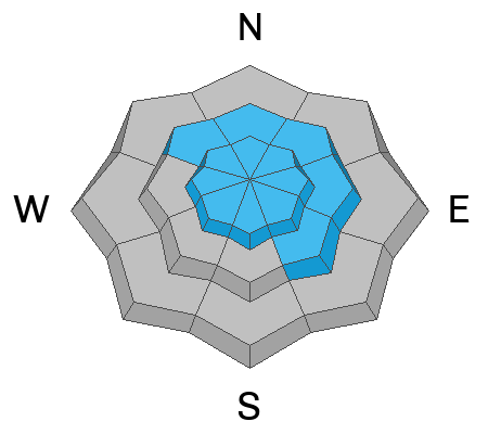
The obvious concern is triggering a recent drift or slab of snow that formed during the strong wind event. It's unclear how sensitive these will be today. What we do know is that there was a tremendous amount of snow being drifted and fresh drifts are the most sensitive during and directly after they form. You will want to avoid any steep slope where the wind has deposited snow.
The good thing about wind drifted snow is that it often stabilizes within a day or two. My strategy today is to go out and hit as many test slopes (small steep terrain features with no consequences if they crack out) that have wind drifted snow on them to get a feel for how sensitive things are. I'll be trying to make them fail. I'll be looking for recent avalanches and taking note what type of terrain they occurred on. I'll do the same thing on Thursday and hopefully see signs of stabilization.
Even if things don't seem very sensitive today, I'll still be avoiding big steep terrain because I know that there was an incredible amount of wind drifting and those drifts may be unpredictable.
Avalanche Problem #2
Cornice
Type
Location
Likelihood
Size
Description
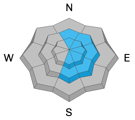
Cornices will most likely be quite large. Avoid them. Period. Do not get on top of them and don't go underneath them.
General Announcements
This forecast is from the U.S.D.A. Forest Service, which is solely responsible for its content. This forecast describes general avalanche conditions and local variations always occur.