Forecast for the Skyline Area Mountains

Brett Kobernik
Issued by Brett Kobernik for
Monday, February 26, 2024
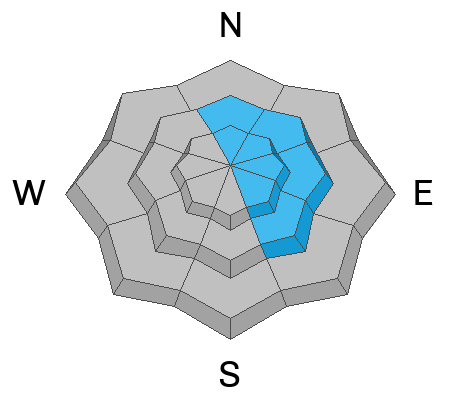
The avalanche danger rating for the Skyline is MODERATE today.
Fresh drifts are forming. These will be sensitive to people.
Avoid any steep terrain where there are recent deposits of wind drifted snow especially on the more east and northeast facing terrain.
Low
Moderate
Considerable
High
Extreme
Learn how to read the forecast here
Weather and Snow
Current Conditions: Wind speeds are starting to pick up along the highest terrain. They are in the moderate to strong category. Temperatures got into the upper 30s on Sunday and are around 30˚F this morning. Riding conditions remained pretty good on Sunday in the upper elevation northerly facing terrain. It will be a different story today given the expected strong wind.
Mountain Weather: Wind. It looks like we're really going to get blasted with this next storm. Expect strong wind from the southwest today. It looks like it's going to get very strong late in the day and tonight. Daytime temperatures will be in the low 30s. We might see a little snow late in the afternoon then the majority of the snowfall happens overnight. I'm still anticipating 7 to 11 inches. The wind looks crazy though so this new snow might really get blown to the next county.
Ad
Avalanche Problem #1
Wind Drifted Snow
Type
Location
Likelihood
Size
Description
We have a fresh round of drifts and slabs of snow forming from the wind today. These are always the most sensitive while they are forming and directly after. If you're getting into higher terrain, simply avoid any steep slope where the wind is drifting and depositing snow. Cornices are likely to break off so stay out from underneath them and certainly avoid being on top of them.
General Announcements
This forecast is from the U.S.D.A. Forest Service, which is solely responsible for its content. This forecast describes general avalanche conditions and local variations always occur.