Forecast for the Skyline Area Mountains

Brett Kobernik
Issued by Brett Kobernik for
Monday, February 27, 2023
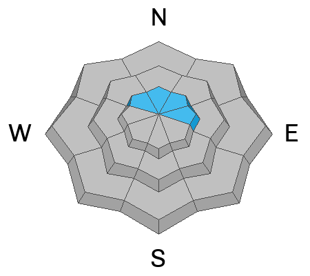
The majority of the terrain on the Skyline has a LOW avalanche danger rating today. However, there is a MODERATE danger in the upper elevation terrain that faces northwest through east.
Human triggered avalanches are possible. The most likely places to trigger something are on very steep high elevation northerly facing slopes where the wind has created fresh drifts and slabs.
ANTICIPATE THE DANGER TO INCREASE OVER THE NEXT FEW DAYS.
Low
Moderate
Considerable
High
Extreme
Learn how to read the forecast here
Weather and Snow
Current Conditions: A minor disturbance on Sunday produced a trace to an inch of snow. Another impulse moved through early this morning bringing about 5 inches of new snow. The wind has been from the southwest in the light to moderate speed category. Temperatures have been in the mid to upper teens over the last 24 hours.

Mountain Weather: We'll have cloudy skies today with the chance for snow. Temperatures will get into the low 20s and we'll see moderate speed wind from the southwest increasing in speed a bit later on. A pretty decent looking snow event should happen later this afternoon and tonight bringing 8 to 12 inches of new snow by Tuesday. The wind could be pretty strong, first from the southwest then from the northwest. We'll have a break on Tuesday then another decent looking storm moves through Wednesday which could produce another 6 to 8 inches of new snow.
Ad
Avalanche Problem #1
New Snow
Type
Location
Likelihood
Size
Description
The new snow fell without much wind so it should be fairly well behaved. However, it doesn't take much wind to transport fresh powder snow so I'd watch out for drifting on the higher elevation more northerly facing slopes. The wind was from the southwest so it will have loaded more northerly facing terrain. As you travel, watch for cracking which indicates unstable snow.

We are expecting more new snow and the wind looks like it'll be strong which will increase the avalanche danger over the next few days.
General Announcements
This forecast is from the U.S.D.A. Forest Service, which is solely responsible for its content. This forecast describes general avalanche conditions and local variations always occur.