Forecast for the Skyline Area Mountains

Brett Kobernik
Issued by Brett Kobernik on
Wednesday morning, February 18, 2026

INCREASING AVALANCHE DANGER THIS WEEK!!

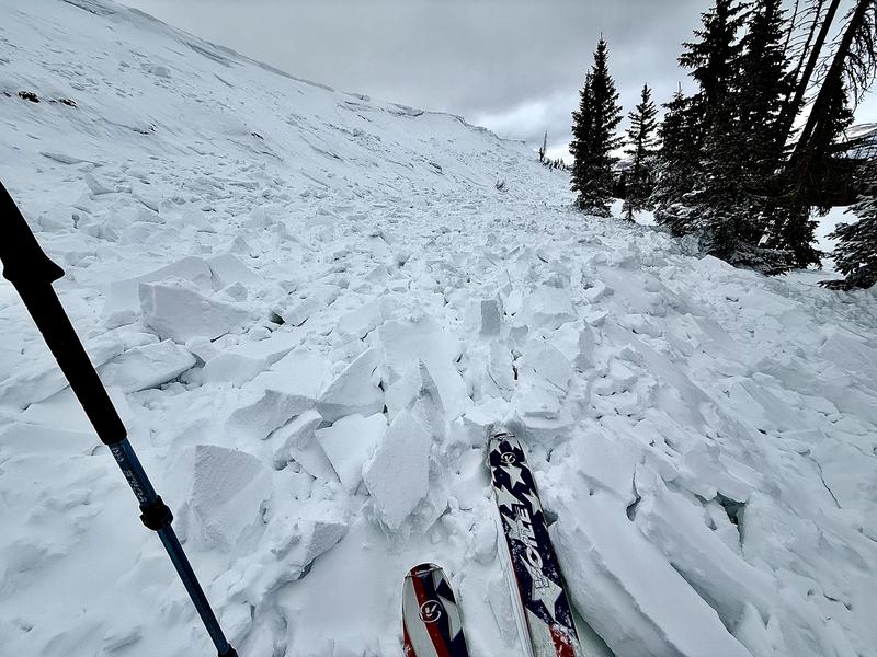
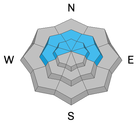
Continued wind and snow today will push the avalanche danger to HIGH on or below upper elevation steep slopes that face north through east. Natural avalanches are likely and human triggered avalanches are almost certain. Avoid being on or below steep slopes today.

Low
Moderate
Considerable
High
Extreme
Learn how to read the forecast here
Avalanche Warning

What: The avalanche danger for the warning area is rising to HIGH today.

Where: The mountains of Northern, Central, and Southwestern Utah, as well as Southeastern Idaho.

Impacts: Recent heavy snow combined with strong wind is creating widespread areas of unstable snow. Both human-triggered and natural avalanches are likely. Avalanches will increase in size and likelihood throughout the day.

What to do: Avoid all avalanche terrain. Stay off of and out from under slopes steeper than 30°. Carry and know how to use avalanche rescue equipment. Find safer riding conditions on slopes less than 30° with no overhead hazard

Warning Times: Wednesday, 2/18/26 at 6:00 AM MST through Thursday, 2/19/26 at 6:00 AM MST

Weather and Snow

General Conditions: Only a few inches of snow accumulated over the last 24 hours. We are in the 6 to 8 inch range since the beginning of the storm Monday night. The real news is the crazy amount of southwest wind we had Monday night and early Tuesday. It was the strongest that we've seen all winter. Speeds hit 80mph on some of the highest peaks. Temperatures have been around 20°F. The new snow if fairly dense. You'll find its consistency somewhat variable due to the wind. It's currently snowing.

Mountain Weather: We'll see more snow and wind today. Wind starts out from the southwest, then shifts more from the northwest later on. Speeds will increase from moderate this morning to strong by midday. A cold front moves through midday, which will produce a good shot of snow. I'm thinking we should see 3 to 6 inches of snow or maybe a bit more by midnight. Temperatures will drop into the single digits. The storm system keeps churning through and we should see another 2 to 4 inches of snow Thursday night into Friday.
Recent Avalanches

During fieldwork on Tuesday I found one avalanche that had just released not long before I got there. It was in the steep terrain south of Fairview Lakes just below State Road 31. Strong wind was actively loading the slope until the old weak snow couldn't take it anymore and failed. I measured it at 600 feet wide. It averaged 12 to 16 inches deep with deeper areas near the cornice. It only ran about 150 feet before due to a bench just below the very steep slope. This avalanche tells me that there were most likely other natural avalanches that were occurring.

Avalanche Problem #1
Persistent Weak Layer
Type
Location
Likelihood
Size
Description

We haven't picked up a large amount of snow from this storm. What is making things so dangerous is how weak the old snow is and how windy it has been. The wind drifts snow and rapidly loads slopes. The widespread weak layer can't hold much weight, and it fails, triggering an avalanche.

With additional snow and wind expected today, the danger will increase. The size of the avalanches will be bigger and there will most likely be more of them. All you can do at this point to stay safe is to avoid steep slopes and stick to lower-angle terrain.

General Announcements
This forecast is from the U.S.D.A. Forest Service, which is solely responsible for its content. This forecast describes general avalanche conditions and local variations always occur.