Forecast for the Skyline Area Mountains

Brett Kobernik
Issued by Brett Kobernik on
Tuesday morning, February 17, 2026

INCREASING AVALANCHE DANGER THIS WEEK!!

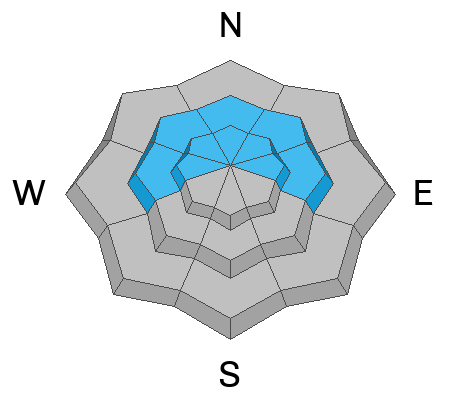
Strong wind and a shot of new snow have increased the avalanche danger to CONSIDERABLE. Human-triggered avalanches are likely today.

The message for today and the rest of the week is to avoid being on or below steep slopes above 8500' on the north half of the compass.

Low
Moderate
Considerable
High
Extreme
Learn how to read the forecast here
Avalanche Watch

What: Heavy snowfall and strong winds are increasing avalanche danger across the mountains of Northern and Central Utah, as well as Southwestern Utah and Southeast Idaho. Forecasters at the Utah Avalanche Center expect dangerous, complex avalanche conditions to develop on many slopes this week, with large natural and human-triggered avalanches likely.

When: This Avalanche Watch is issued on Tuesday, 2/17/26 at 6:00 AM MST through 6:00 AM MST Wednesday, 2/18/26.

Where: The Avalanche Watch is for the mountains of Northern, Central, and Southwestern Utah, as well as Southeastern Idaho.

Impacts:

  • Dangerous avalanche conditions are expected to develop on many slopes.

  • Avalanches can be triggered on slopes steeper than 30 degrees. They may also be triggered remotely (from a distance) or from below.

What to do:

  • Avoid traveling on or underneath steep terrain at mid and upper elevations in the backcountry.

  • Carry and know how to use avalanche rescue equipment, including a transceiver, shovel, and probe.

  • Find safer riding conditions on slopes less than 30 degrees with no overhead hazard.

Weather and Snow

General Conditions: We picked up 3 to 6 inches of snow overnight across the Skyline. The wind from the southwest has been VERY strong. The wind has been drifting a lot of snow. Some weather stations actually lost snow depth because the wind is stripping the snow. Temperatures dropped into the mid-teens. I'm not sure what to expect as far as riding conditions today. Sheltered terrain will probably be quite nice. Wind-exposed terrain will be devastated, I'd guess.

Snowfall continues on Wednesday, with another wave expected to bring an additional 6 inches or so.

Mountain Weather: We'll have cloudy skies and periods of snow today. I'm expecting another 3 to 5 inches by midnight. We've probably seen the strongest wind but it looks like it will remain fairly strong still during the day. It'll continue from the southwest. Temperatures will only get up to around 20°F today.,
Avalanche Problem #1
Persistent Weak Layer
Type
Location
Likelihood
Size
Description

Old snow from December and January is very weak. We are now adding layers on top of that weak snow. We have seen cracking, collapsing, and small avalanches from the storm last week. We will see more of that this week, and the avalanches will get larger and more dangerous.

The only way to mitigate the danger is to avoid being on or below steep slopes. This is a dangerous situation, and I urge people to use caution this week.

General Announcements
This forecast is from the U.S.D.A. Forest Service, which is solely responsible for its content. This forecast describes general avalanche conditions and local variations always occur.