UDOT PLANNED AVALANCHE CLOSURES!!

Forecast for the Skyline Area Mountains

Brett Kobernik
Issued by Brett Kobernik for
Friday, February 10, 2023
Overall, the avalanche danger rating on the Skyline is LOW.
There may be a few scattered areas along the higher ridges where you could get a wind slab to crack out.
A "pockety" MODERATE danger rating exists along the upper elevation north through east through south facing steep slopes.
Low
Moderate
Considerable
High
Extreme
Learn how to read the forecast here
Special Announcements
We are putting on a Backcountry 101 avalanche class for motorized users next week, February 17 & 18. We will do online presentations on Friday evening and a full day out in the mountains on Saturday.
MORE DETAILS HERE
If you have questions, EMAIL ME HERE
Weather and Snow
Current Conditions: It was a gorgeous day in the mountains on Thursday with sunny skies and cool temperatures. The riding conditions took a hit from Wednesday's strong wind. A temperature inversion is upon us again with ridgeline temperatures in the low to mid 20s and readings down in the canyons in the teens or even single digits. The wind has been calm to light from the north.
Mountain Weather: It will be another lovely day in the mountains with plenty of sun and high temperatures around 30˚F or a bit warmer. The wind will be light from the south and may increase slightly late today. The next three days look similar although we'll see clouds on Saturday. The next storm is advertised for midweek. It doesn't look huge but hopefully it'll provide a much-needed refresher.
Recent Avalanches
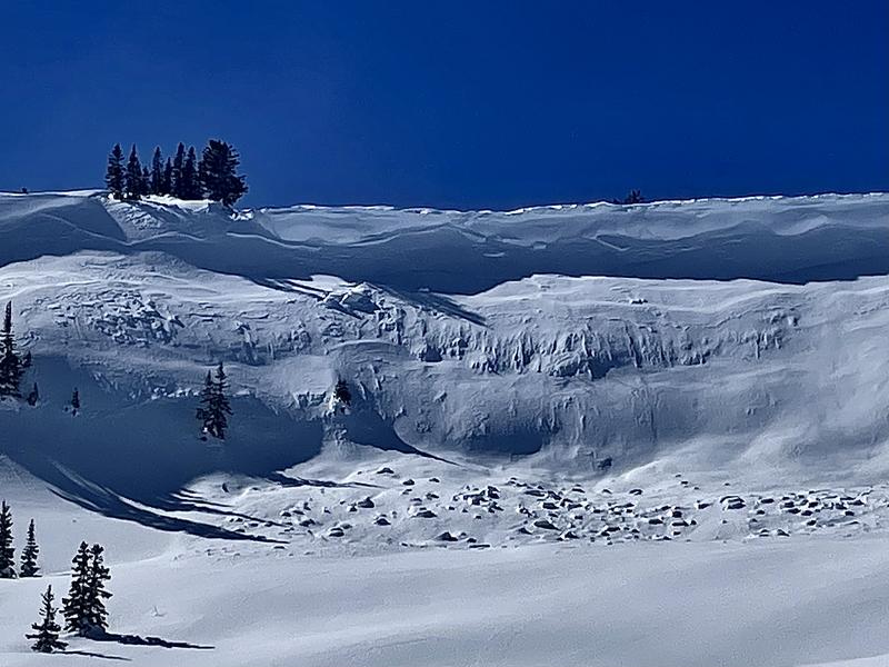
There was pretty widespread natural avalanche activity along the corniced ridge lines during Wednesday's strong wind. Most of these avalanches weren't all that large but a few could've caused a person harm. The avalanche in the photo below is the largest one that I found. I definitely wouldn't want to get caught in a slide like that.
Ad
Avalanche Problem #1
Wind Drifted Snow
Type
Location
Likelihood
Size
Description
During my travel on Thursday I poked and prodded at LOTS of wind drifts and wind slabs. I was not able to get anything to crack or release. They were stubborn and seem welded into place now. I'd still use caution on the bigger steeper slopes in the upper elevations. To get anything to crack out you'll need a slope approaching 40˚ now. If you avoid steep slopes with cornices or recent deposits of wind drifted snow, you'll avoid any avalanche danger today.
General Announcements
This forecast is from the U.S.D.A. Forest Service, which is solely responsible for its content. This forecast describes general avalanche conditions and local variations always occur.