Forecast for the Skyline Area Mountains

Brett Kobernik
Issued by Brett Kobernik for
Sunday, December 4, 2022
DANGEROUS AVALANCHE CONDITIONS EXIST!
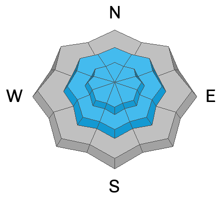
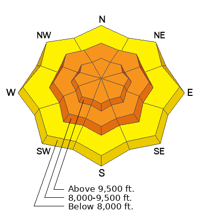
The avalanche danger is CONSIDERABLE today. Human triggered avalanches are likely. These avalanches can be triggered remotely from a long distance away from you.
Stay off slopes steeper than about 30˚ in steepness. Make sure you are not underneath steep slopes where avalanches could come down on top of you.
Low
Moderate
Considerable
High
Extreme
Learn how to read the forecast here
Special Announcements
Join the Utah Avalanche Center and the Division of Outdoor Recreation to celebrate the Fourth Annual Avalanche Awareness week, from December 4 - December 11. CLICK HERE to view the full list of events for the week.
Weather and Snow
Current Conditions: The northern half of the Manti Skyline (Horseshoe Mtn & north) picked up 4 inches of new snow Saturday afternoon during a quick hitting warm storm. It looks like the new snow is fairly dense. Temperatures remain quite mild with most stations reading around 30˚F. The wind is calm to light from the south.
Mountain Weather: We'll have cloudy skies and mild temperatures today along with light southerly wind that should increase in speed a bit later on. The next storm system moves through Monday and Tuesday with a couple of small impulses that should give us a few more inches of snow. There are a number of other small storms that will move through during the week, each one adding a few more inches of snow.
Recent Avalanches
I recieved a report of a small skier triggered avalanche on Saturday. It was remotely triggered from a distance and no one was caught. More DETAILS HERE.
Ad
Avalanche Problem #1
Persistent Weak Layer
Type
Location
Likelihood
Size
Description
The snowpack continues to show us that it is unstable. The avalanche described above is one example. Also on Saturday, my partner and I experienced lots of cracking a collapsing while traveling on skis. We remotely collapsed a slope hundreds of feet away from us. This is all due to a buried Persistent Weak Layer that formed during the two week dry spell in November and is now being overloaded with new snow. Dangerous avalanche conditions are going to be with us for a while, hence why we call this a Persistent Weak Layer.
General Announcements
This forecast is from the U.S.D.A. Forest Service, which is solely responsible for its content. This forecast describes general avalanche conditions and local variations always occur.