Join the Utah Avalanche Center and the Division of Outdoor Recreation to celebrate the Fourth Annual Avalanche Awareness week, from December 4 - December 11.
CLICK HERE to view the full list of events for the week.
Current Conditions: The wind finally let off and is fairly light from the southwest this morning. Overnight temperatures were around 20˚F. The wind did a number on the riding conditions but we did find some great skiing on Friday in fresh powder.
Mountain Weather: We're going to have cloudy skies today with the chance of snow later on. I'm only expecting a few inches of snow out of this. High temperatures will get into the upper 20s and southwest wind should increase in speed some but won't get too strong. We'll see clouds on Sunday with a continued southwest flow and mild temperatures. Another storm moves in on Monday that should bring another little shot of snow. The weather pattern still looks active through the middle of the month.
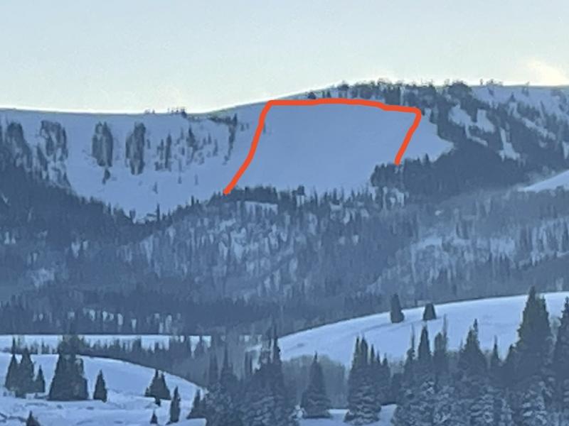
My partner and I spotted a sizeable avalanche that released naturally on Friday. It was in lower Staker Bowl. We could clearly see the fracture line using a scope. The avalanche was 1 to 2 feet deep and about 400 feet wide. While we didn't inspect it up close, there is no doubt why it failed. A buried Persistent Weak Layer of sugary faceted snow is in place. We had a couple of windy storms and on Friday the wind was blowing and drifting snow onto this slope until the weak layer was overloaded and failed.