Forecast for the Skyline Area Mountains

Brett Kobernik
Issued by Brett Kobernik for
Friday, December 24, 2021
WARNING!! DANGEROUS AVALANCHE CONDITIONS EXIST!!
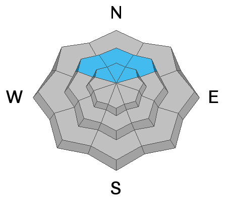
The avalanche danger is HIGH today. Natural and human triggered avalanches are likely. Travel in avalanche terrain is DEFINITELY NOT RECOMMENDED!
Low
Moderate
Considerable
High
Extreme
Learn how to read the forecast here
Avalanche Warning
What
THE AVALANCHE DANGER IS HIGH WITH DANGEROUS AVALANCHE CONDITIONS.
When
IN EFFECT FROM 6 AM MST THIS MORNING TO 6 AM MST SATURDAY.
Where
FOR THE MOUNTAINS OF MUCH OF THE STATE OF UTAH, INCLUDING THE WASATCH RANGE...BEAR RIVER RANGE...UINTA MOUNTAINS...THE MANTI-SKYLINE...THE FISH LAKE REGION…PAHVANTS…TUSHARS…AND THE CEDAR CITY AREA MOUNTAINS.
Impacts
RECENT HEAVY SNOW COMBINED WITH WIND WILL LIKELY CREATE WIDESPREAD AREAS OF UNSTABLE SNOW. BOTH HUMAN TRIGGERED AND NATURAL AVALANCHES ARE LIKELY. STAY OFF OF AND OUT FROM UNDER SLOPES STEEPER THAN 30 DEGREES.
Special Announcements
Avalanche forecasters discuss avalanche concerns from across the state of Utah:
Weather and Snow
Current Conditions
It's official. We're getting clobbered by snow. As of 6am we are up to about 20 inches of new snow in 24 hours and more to come during the day. The snow appears to be quite high density meaning it has a lot of water in it. The southwest wind was very strong Thursday night and since has slowed down. Temperatures have cooled into the low to mid 20s. Backcountry travel will most likely be difficult today due to the large amount of new snow.
Mountain Weather
The storm system stalled out through Central Utah overnight and it should produce more periods of snow during the day and into tonight. An additional 5 to 8 inches of snow by Saturday morning would not surprise me. High temperatures today won't get much warmer than they are now and will cool into the mid teens overnight. It looks like the wind is going to increase again later today with pretty strong speeds from the southwest. We'll have a break in the weather Saturday then another storm is on track for Sunday and another around Tuesday.
Ad
Avalanche Problem #1
Persistent Weak Layer
Type
Location
Likelihood
Size
Description
Old weak snow (a Persistent Weak Layer) from October is now buried from early December snow storms and has just gotten prodded big time by this big storm. It is not going to be happy. Natural avalanches are almost certain today on upper elevation northwest, north and northeast facing slopes. Do not screw around with any of these steep slopes and be sure to stay well clear of run-out zones. That means make sure that even if you are on low angle terrain that there are no steep slopes above you. It is VERY possible that you can trigger an avalanche from a distance today. This means you could trigger an avalanche from flat terrain that could come down from steep slopes above you and bury you.
Avalanche Problem #2
New Snow
Type
Location
Likelihood
Size
Description
The new snow itself could be unstable today especially if the wind increases again later on. Whenever we deal with this much snow in a short period of time, you must treat it as guilty until proven innocent. Watch for cracking in the snow surface to give you clues to whether the new snow is unstable. The best approach is to let the storm take its course and stay out of avalanche terrain until we get a handle on how all this new snow is behaving.
Additional Information
  • Always follow safe backcountry travel protocols. Go one person at a time in avalanche terrain, while the rest of your party watches from a safe area.
  • Check your avalanche rescue equipment, change your batteries, and practice often with your backcountry partners.
  • Be very careful, keep your speed down, and stay in control. Encounters with shallowly buried rocks or down trees in the early season have led to many season-ending injuries.