Forecast for the Skyline Area Mountains

Brett Kobernik
Issued by Brett Kobernik for
Thursday, December 23, 2021
THE AVALANCHE DANGER WILL BE INCREASING FRIDAY AND INTO NEXT WEEK.
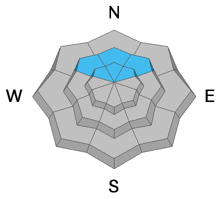
A CONSIDERABLE avalanche danger remains on upper elevation steep northwest, north and northeast facing slopes. Human triggered slab avalanches are likely in this terrain. Continue to avoid these steep slopes until we see conditions improve.
Low
Moderate
Considerable
High
Extreme
Learn how to read the forecast here
Avalanche Watch
We've issued an Avalanche Watch which means we are expecting the avalanche conditions to get very dangerous:
HEAVY DENSE SNOWFALL AND STRONG WINDS WILL LIKELY CREATE VERY DANGEROUS AVALANCHE CONDITIONS. BOTH HUMAN TRIGGERED AND NATURAL AVALANCHES ARE LIKELY. STAY OFF OF AND OUT FROM UNDER SLOPES STEEPER THAN 30 DEGREES.
Weather and Snow
Current Conditions
The Manti Skyline has picked up a couple of inches of snow this morning in the higher terrain. Temperatures remained mild with lows only in the upper 20s. Southwest wind is in the moderate speed range.
Mountain Weather
The big excitement is the anticipated period of storms ahead. The first one for today and through Friday looks like it's on track. It'll be quite warm today with the rain/snow level up around 7000 to 8000'. Southwest wind looks pretty strong through tonight then switching more westerly and slowing on Friday. We should see a period of snow in the mountains mid day today bringing 3 to 6 inches. Another period of snow will start later tonight and last into Friday afternoon. This should bring another 10 to 14" of snow with somewhat colder air. Water amounts are quite impressive with this storm. There are storms lined up for Sunday, Tuesday and late next week.
Ad
Avalanche Problem #1
Persistent Weak Layer
Type
Location
Likelihood
Size
Description
A buried persistent weak layer of faceted snow from October is our main focus. This layer has produced widespread collapsing and cracking along with some natural avalanche activity over the last week. It will continue to be dangerous and get more dangerous as we add more snow on top of it over the next week. This weak layer is present on slopes above about 9000' that face northwest, north and northeast.