UDOT PLANNED AVALANCHE CLOSURES!!

Forecast for the Skyline Area Mountains

Brett Kobernik
Issued by Brett Kobernik for
Thursday, November 22, 2018
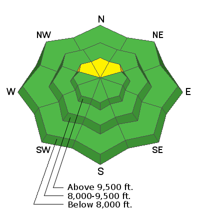
The avalanche danger today is generally LOW. We will have increasing avalanche danger on the high elevation north facing slopes as the storm adds snow on top of old weak pre-existing snow from early October. The danger will most likely rise to MODERATE or CONSIDERABLE in terrain that faces northwest through northeast above about 9700' in elevation. Terrain outside of that description will have a LOW avalanche danger.
Low
Moderate
Considerable
High
Extreme
Learn how to read the forecast here
Weather and Snow
The storm is upon us. It started early this morning and we're up to about 4" new snow now at 1pm. There is not really enough snow yet for any winter recreation but this could change soon with the current storm and potentially some more storms on the horizon.
There is some pre-existing weak sugary snow on the highest elevation northerly facing slopes. This will be something to look out for as we stack new snow on top of it. Stay tuned for how this old weak snow may influence the future avalanche conditions. I'll be watching this intently and will provide more information soon.
Ad
Additional Information
We are very proud to introduce our new website for the 2018-19 winter season. This will provide an easier and cleaner way to view all of the snow and avalanche information that you've come to rely on. We are quite happy with how the new website performs on mobile devices as well. We think you'll find the desktop or laptop experience pleasant as well. We are still tying up some loose ends so bear with us.
LINK TO VIDEO CONTAINING INFO ABOUT NEW WEBSITE