UDOT PLANNED AVALANCHE CLOSURES!!

Forecast for the Skyline Area Mountains

Brett Kobernik
Issued by Brett Kobernik for
Saturday, January 5, 2019
Overall, the avalanche danger remains generally LOW in the majority of the terrain along the Skyline. A MODERATE avalanche danger exists along the higher northwest through east facing slopes where a recent or fresh wind drift might be triggered.
The avalanche danger will be increasing over the next few days as a windy storm moves through.
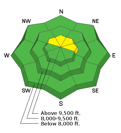
Low
Moderate
Considerable
High
Extreme
Learn how to read the forecast here
Weather and Snow
Riding conditions have remained good to excellent all week. Wind has been generally light so there hasn't been a huge amount of wind drifted snow.
Today we'll see increasing clouds and increasing south wind ahead of a storm that will move through tonight into Monday. The majority of the snow will fall on Sunday and I think we could see 8 to 12" by the time it moves out on Monday. The wind will be strong at times especially on Monday. This will almost certainly increase the avalanche danger.
Ad
Avalanche Problem #1
Wind Drifted Snow
Type
Location
Likelihood
Size
Description
Wind is going to be our main concern over the next few days. It will be from the southwest and will start to increase in speed later today although I don't think it'll get all that strong today. Regardless, if you see snow being transported by the wind, it means fresh drifts are most likely forming somewhere and will be sensitive.
Don't let your guard down!
  • Make sure everyone is carrying the proper avalanche gear.
  • Only put one person on a steep slope at a time and don't regroup at the bottom of steep slopes.
  • Watch for the southerly wind to start drifting snow later today as the wind increases.
Additional Information
A weak layer of snow formed on the surface in mid December during a dry spell. It is now buried and the question is will it cause avalanches as we add more snow on top of it. For more detailed thoughts on this, check out THIS BACKCOUNTRY OBSERVATION.

This forecast is from the U.S. Forest Service, which is solely responsible for its content. This forecast describes general avalanche conditions and local variations always occur.