Check out our Holiday Auction - Sign Up for the Utah Snow and Avalanche Workshop (USAW)

Forecast for the Skyline Area Mountains

Brett Kobernik
Issued by Brett Kobernik on
Sunday morning, January 6, 2019
Heads up - The avalanche danger has changed in the past 24 hours and dangerous avalanche conditions are beginning to materialize.
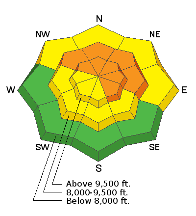
The avalanche danger will increase to CONSIDERABLE by mid day today. Wind strong enough to drift the new snow will create unstable areas on any steep slope that is getting loaded but especially on northwest through east facing slopes in the mid and upper elevations. If you are heading out today your best bet is to stick to mid elevation lower angle terrain.
Low
Moderate
Considerable
High
Extreme
Learn how to read the forecast here
Weather and Snow
We've picked up 3 to 5 inches of snow overnight and it's been a bit windy. Southwest wind has been blowing in the moderate speed range. This is certainly enough to stir the new snow up. We'll see continued snowfall today with the wind speeds increasing and veering to the west. There will be a little break tonight and then another more windy impulse will move through late tonight into Monday.
This storm looks decent for snow totals and I'm thinking we should see 8 to 12" total. However, this is not going to be the pristine powder like our New Year's storm. We have quite a bit more wind with this one. Also, Monday's impulse looks like it will produce higher density snow and this is when we'll see the strongest wind as well. I'm guessing this is going to make an "upside down" snow layering situation where the surface snow is heavier than the snow underneath it.
Ad
Avalanche Problem #1
Wind Drifted Snow
Type
Location
Likelihood
Size
Description
The wind accompanying this storm is going to be what increases the avalanche danger today and Monday. The freshly formed drifts may be sensitive on their own but I've been following a weak layer in the middle of the snowpack which may fail as well under the weight of these wind slabs. You should watch for areas of wind drifted snow on all aspects in the mid and upper elevations but things will be more dangerous on the higher elevation northwest through southeast facing slopes where the wind will drift the most snow.
Additional Information
This forecast is from the U.S. Forest Service, which is solely responsible for its content. This forecast describes general avalanche conditions and local variations always occur.