Donate to the 2024 Spring Campaign to help rebuild the UAC website.

Forecast for the Skyline Area Mountains

Brett Kobernik
Issued by Brett Kobernik for
Monday, January 7, 2019
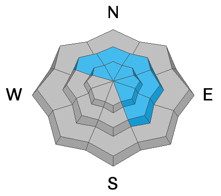
The avalanche danger is HIGH today. Travel in avalanche terrain is not recommended. Strong west wind is drifting snow which will overload slopes and cause natural avalanches. Human triggered avalanches are almost certain in steep upper elevation terrain. Stay off of and out from underneath any steep slope in the mid and upper elevations.
Low
Moderate
Considerable
High
Extreme
Learn how to read the forecast here
Weather and Snow
Another round of snow is happening along the Skyline this morning. Wind is strong from the west southwest along the ridges and it's been getting down into the drainages also. Snow totals are hard to pin down. The wind has been blowing snow at measuring sites and the Snotel weather station network went down last night. The best I can tell is that we have 10 to 14 inches of new snow. It appears that the Fairview Canyon region picked up the most.
Ad
Avalanche Problem #1
Wind Drifted Snow
Type
Location
Likelihood
Size
Description
The wind is the big issue with this storm. It surely loaded many slopes rapidly with wind drifted snow. These are suspect and should not be messed with. Stick to low angle terrain in meadows if you are heading out today. We'll let the dust settle and reevaluate the avalanche conditions for Tuesday.
Additional Information
This forecast is from the U.S. Forest Service, which is solely responsible for its content. This forecast describes general avalanche conditions and local variations always occur.