Forecast for the Salt Lake Area Mountains

Drew Hardesty
Issued by Drew Hardesty for
Friday, April 17, 2020
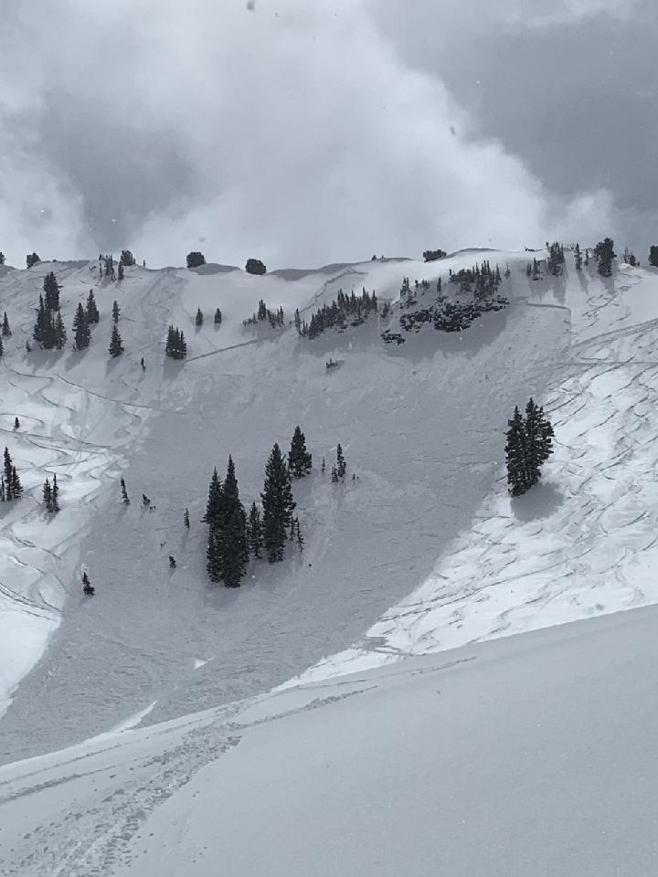
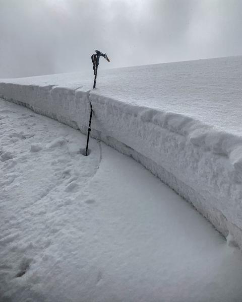
Today has avalanche accident written all over it.
Areas of CONSIDERABLE avalanche danger exist primarily in upper elevation northwest through east facing slopes. Human triggered avalanches 10-20" deep and up to 250' wide are probable on many steep slopes and some may be triggered at a distance. The danger for wet avalanches will rise to CONSIDERABLE on all steep sun exposed slopes today.
Remember that slope angle is the great equalizer. Low angle slopes continue to ride well. Low Risk High Reward.
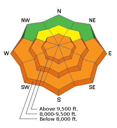
Low
Moderate
Considerable
High
Extreme
Learn how to read the forecast here
Special Announcements
The Avalanche Research Program at Simon Fraser University is conducting an online survey to examine how people use avalanche safety information. They want to hear from all backcountry users to understand how they process information provided in public avalanche forecasts. Anyone who completes the survey before May 15th will be entered to win cash prizes.
Weather and Snow
Skies are clear. Winds are generally light from the west-northwest. Mountain temperatures are in the single digits and low teens.
For today, we'll have sunny skies, light winds backing to the southwest, and temperatures rising to the mid-40s.
Storm totals from Wednesday/Thursday are roughly 12" (1.30"SWE) in the upper Cottonwoods and about half that along the PC ridgeline. Some south to west facing slopes will have slight suncrust this morning.

One of the many close calls from yesterday below. Main Days in BCC; Northeast facing at 10,100'. 8-10' deep and 200' wide. (Belabi video).
Recent Avalanches
By my count, there were 31 reported human triggered avalanches yesterday with at least four people caught and carried with one knee injury. These slides were on all aspects at the mid and upper elevations but primarily on steep northwest to east facing slopes. Most were 8-16" deep and 75' wide with a couple outliers 250' wide. These were failing within the new snow or at the new/old snow interface on last week's temperature crust. Collapsing on this layer was noted; cracking was widespread, with a few avalanches triggered remotely (from a distance). Some took out previous tracks, some took out other skiers below. A couple notable photos. (High Greeley/Richards, South Monitor/White). A full list can be found in the menu above.
Side note: In 2015, Bruce Jamieson and Alan Jones did a study on non-fatal avalanche involvements and estimated that 90% of these go unreported. Is it possible that there were over 300 human triggered slides yesterday?
Ad
Avalanche Problem #1
New Snow
Type
Location
Likelihood
Size
Description
The storm snow interface down roughly 12-18" on last week's temperature crust (even on upper elevation northerly aspects) will still be sensitive to skiers and riders today. The structure is poor with a mix of weak faceted grains above a hard crust...with a consolidating slab now on top. Collapsing and cracking may or may not be evident. Some of these avalanches may still be triggered at a distance. These avalanches may occur both in and out of wind affected terrain. They may be a bit less sensitive than yesterday but may have wider propagation. They will be most pronounced on upper elevation northwest through east facing aspects, but still possible in other terrain.
Absent clear signs of instability, simple snow tests on low angle representative slopes (Extended Column Tests and others) should tell the tale. Extra Caution is warranted.

Quote from long time avalanche pro Matt Leri yesterday - "intentionally triggered a wind slab below: 150' wide up to 1' deep. Watched as a small side slope sympathetically slid 100' away from bigger slab. Turned around and had a great day turning laps in (low angle) USA Bowl: 6-8" not wind affected."
Avalanche Problem #2
Wet Snow
Type
Location
Likelihood
Size
Description
Despite cool morning temperatures, the storm snow will heat up in a hurry with direct sun and temps warming to the mid 40s at the mid-elevations, the mid-30s up high. 8-16" of cold snow will become damp and then wet and unstable, running fast and far on last week's suncrusts. Natural and human triggered avalanches will be likely during the heat of the day. Both wet sluffs and wet slabs are possible. When the snow starts becoming damp, move to a cooler slope or lower angle terrain.
Additional Information
Information on outdoor recreation - The State of Utah created this webpage with information about recreating on both state and federal public lands during the current health crisis.

Skiing and riding at closed ski resorts - Some resorts allow access now, and some do not. Please check HERE for the latest info on ski area access.

New to the backcountry (including riding at closed resorts) - Watch the award-winning, 15 minute Know Before You Go video, or take the 5-part, free online-learning series.
General Announcements
This information does not apply to developed ski areas or highways where avalanche control is normally done. This forecast is from the U.S.D.A. Forest Service, which is solely responsible for its content. This forecast describes general avalanche conditions and local variations always occur.