AVALANCHE WARNING!! Tap for info

Forecast for the Salt Lake Area Mountains

Nikki Champion
Issued by Nikki Champion on
Thursday morning, March 9, 2023
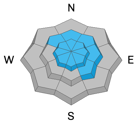
Today the avalanche danger is MODERATE on all aspects and all elevations. Both hard and soft slab avalanches remain possible within layers of new snow from the last two weeks. Additionally, the elevated winds may create unstable slabs of wind-drifted snow at mid and upper elevations.
Avalanche danger will be on the rise as we receive heavy snowfall, high winds, and overall warm temperatures with the incoming storm.
Low
Moderate
Considerable
High
Extreme
Learn how to read the forecast here
Special Announcements
To help you safely enjoy the backcountry, the UAC team is constantly evaluating and implementing new programs and technologies. Donate to the Spring Campaign to help our team implement innovative tools and better provide you with the information you rely on. Thank You!
Weather and Snow
This morning, the skies are overcast with light snowfall, overnight snow totals are between 6-8" favoring the upper cottonwoods. Mountain temperatures have dropped, and are sitting in the single digits and low teens F. Along 9000' ridgelines winds are blowing primarily from the southwest at speeds of 5-15 mph, with gusts up to 20 mph. At the 11,000' ridgelines, overnight winds gusted up to 50 mph.
Today, any lingering snow showers should taper off early this morning and the skies should become party cloudy, and even partly sunny mid-day. After a brief clearing, the cloud cover will begin to increase again this afternoon. Temperatures will climb into the upper 20s and low 30s F. Winds will remain west, south-westerly, and begin to rise.
Tonight, snow associated with the atmospheric river event should begin around midnight and continue through Friday. Accompanying this event comes high winds, with speeds up to 95 mph at the 11,000' ridgelines. Overnight snowfall totals should be between 2-4" of new snow. According to NWS forecasters, "this storm will be fed by a warmer inland penetrating atmospheric river with denser snow and higher snow levels." The rain snowline could be high at the beginning of the storm, with the rain snowline pushing near 8500' Friday afternoon. Overall, snow totals for this initial event will be between 12-26" of snow (1.25-2.5" of water). Another brief break is possible Monday before another storm may come on Tuesday.
If you're looking for a day with some sunshine, consider getting out today as the weather will be a wild ride through the weekend (Read more about it from Jim Steenburgh HERE)

Total snow depths are 11-15' in the upper Cottonwoods, 7-10' along the Park City ridgeline, 8-11' in the Ogden area mountains where up to 7' is at some low elevation locations, and 8-10' in the Provo area mountains. Most trailheads have 4' of snow.
Recent Avalanches
The primary avalanches of concern over the past week were mostly on Sunday and Monday, 1-3' deep and 50-300' wide on E and SE aspects between 8300' and 10,600' on a crust that formed during sunshine last Thursday. Additionally, there have been some artificially triggered slides in unskied terrain in Little Cottonwood Canyon on an old rime crust on slopes facing SW, W, and NW. See all the recent slides HERE.
In most cases, it seems these avalanches have simply been breaking on a softer layer of low-density snow on top of these crusts, but there is always a bit of uncertainty with snow. Drew was in upper Big Cottonwood Canyon yesterday, and was unable to get any shears on this interface, and believes the layer is healing. That being said, we are about to add a large load to this interface over the next few days, and it is still worth paying attention too.

Yesterday, there was one report of a cornice fall that entrained new snow and created a small avalanche. This occurred on a NE facing aspect near 10,400' on the Cardiac Ridge Run of Cardiff Fork. 20-30' of cornice broke, entraining 8" of new snow and running 200'.
Ad
Avalanche Problem #1
New Snow
Type
Location
Likelihood
Size
Description
Hard and soft slab avalanches today may break 1-3 feet deep within layers of new snow from the last week or two. All things considered, we have a pretty solid snowpack in the backcountry, but with continuous storms, buried ice crusts, buried rime crusts, softer layers of snow, and very isolated pockets of some facets, conditions remain a bit complicated. The main takeaway is we have a lot of snow, and as we add more stressors in the form of wind, snow, and potentially rain over the next few days these new snow avalanches could break directly on the new snow old snow interface or somewhere deeper within the snowpack on weaker snow or crusts.
The likelihood of triggering one of these avalanches drops every time we have a lull in storms, but snowpack needs more than a brief lull in storms to stabilize, and the trouble this season is that every time we give it a few days to stabilize another storm rolls in.

If the sun comes out midday it wouldn't take much for the new snow to warm quickly, become wet, and begin producing wet loose avalanches on steep southwest to the south to southeast facing slopes today.
Signs that wet avalanches will start happening include; seeing snowballs or pinwheels roll downhill with increasing frequency, and seeing upper layers of snow become increasingly wet. Avoid being on steep solar aspects if the snow has become wet and unsupportable.
Avalanche Problem #2
Wind Drifted Snow
Type
Location
Likelihood
Size
Description
The high southwest winds, in combination with a few inches of new snow, will continue to form fresh slabs of wind-drifted snow along all aspects at upper elevations and mid-elevation leeward terrain features. These wind drifts will be generally shallow but could be sensitive to the weight of a rider today.

Cornices: Yesterday we got a report of a natural cornice fall. Cornices are currently large and only continue to grow in the backcountry. With the incoming warm storm and high winds we could begin to see more cornices breaking naturally. Give cornices, and the edges of cornices a wide berth as they often break farther back than expected. Limit your exposure to slopes below cornices.
Additional Information
While not directly avalanche problems, tree wells, "snow immersion suffocation" and roof avalanches are backcountry dangers worth noting this season with so much snowfall. We shared a message and photos about this tree well hazard on social media last week and were surprised how many people have had close calls and encounters with tree wells. In fact, one person skiing back to the car yesterday in BCC along a summer trail fell into a tree well and required the help of their two partners to get out. Read more HERE.
As for roof avalanches, with the incoming warm temperatures and high rain/snowline those who have considerable snowfall on their roofs should be extra cautious going into the weekend.
General Announcements
This information does not apply to developed ski areas or highways where avalanche control is normally done. This forecast is from the U.S.D.A. Forest Service, which is solely responsible for its content. This forecast describes general avalanche conditions and local variations always occur.