Forecast for the Salt Lake Area Mountains

Greg Gagne
Issued by Greg Gagne for
Monday, March 7, 2022
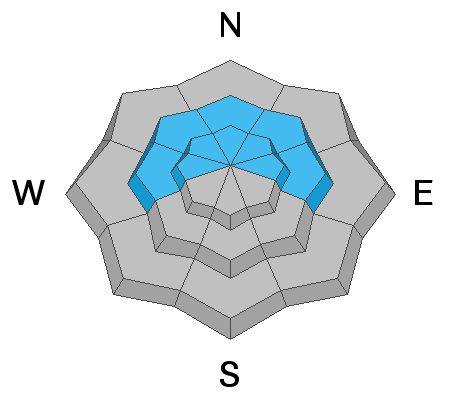
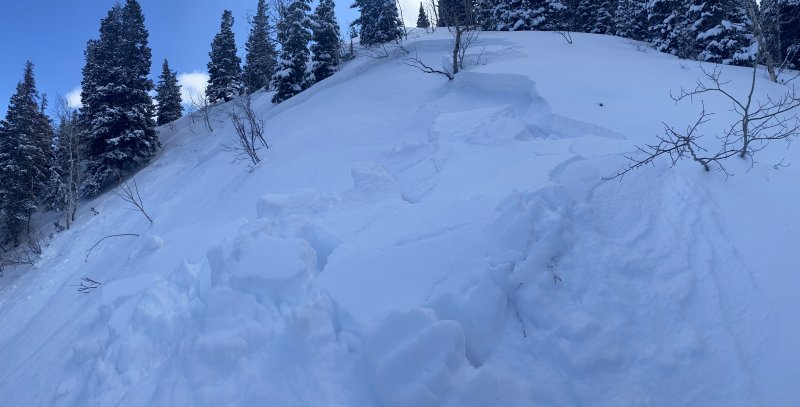
There is a MODERATE danger on steep west to north to east-facing aspects at the mid and upper elevations where it is possible to trigger an avalanche 1-2' deep failing on a buried persistent weak layer of faceted snow.
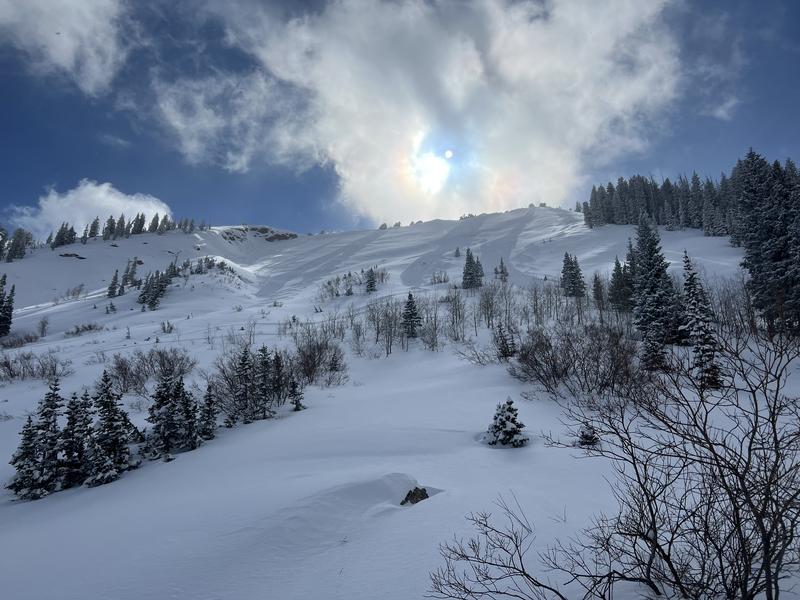
There is a MODERATE danger on all aspects at the mid and upper elevations. This involves fast and long-running sluffs in the new snow as well as isolated pockets of fresh wind drifts at the upper elevations. Wet-loose avalanches are possible if the slope you are on has any extended period of direct sunshine.
There is a LOW avalanche danger on all low-elevation slopes.
Low
Moderate
Considerable
High
Extreme
Learn how to read the forecast here
Special Announcements
TONIGHT: Join us tonight, Monday, March 7th at 7:00 PM for a State of the Snowpack presentation with Craig Gordon, hosted by Black Diamond at their Trolley Square retail store (602 E 500 S C102, Salt Lake City, UT 84102). Snow has once again blanketed the Wasatch Mountains, and more is on the way! Join us as we review the most up-to-date information on the current snowpack, and what to expect with the potential for incoming storms.

Join us on Wednesday, March 9th at the Broadway Theater in SLC for a special screening of the award-winning film “BURIED,” a feature-length documentary based on the events and circumstances surrounding the 1982 avalanche in Alpine Meadows, CA. The show starts at 7 pm. Purchase tickets HERE.
Weather and Snow
Currently: Temperatures are in the single digits and winds are from the west/northwest and light - averaging less than 10 mph with gusts in the teens at mid-elevations. Wind speeds at 11,000' are much stronger, averaging in the 20's with gusts in the 30's mph.
Today: Partly cloudy skies with temperatures in the teens. Winds will be from the north/northwest and moderate, averaging in the low teens with gusts near 20 mph along exposed mid-elevation ridges. Along the upper-most ridges, winds will average in the upper teens with gusts in the 30's mph.
Enjoy today's brief period of ridging as a trough is forecasted to arrive midweek bringing snow and colder temperatures.
Recent Avalanches
Avalanche activity on Sunday involved long-running sluffs in the storm snow and two avalanches breaking down 12-16" into the Jan/Feb facets in Summit Park and in the Memorial Couloirs on Mount Olympus.
Ad
Avalanche Problem #1
Persistent Weak Layer
Type
Location
Likelihood
Size
Description
The Saturday/Sunday storm did not seem to be enough of a load to stress the Jan/Feb drought persistent weak layer (PWL), but there remains the possibility of triggering an avalanche 1-2' deep that fails on this layer of faceted snow in localized terrain at the mid and upper elevations on slopes facing west through north and east. Sunday's avalanches in Summit Park (photo below) and in the Memorial Couloirs are perfect examples of this type of isolated terrain.
On Sunday, I was in Millcreek Canyon, returning to terrain that I had visited the week prior. When I was there on 2/26, I could not find a stronger slab on top of the Jan/Feb layer of facets. But on Sunday, I was now finding a denser/stronger slab due to settlement and warm temperatures this past week and I was able to get cracking in the slab with failures down 12-16" in the layer of faceted snow. The take-home message for me is to still assess each slope where the PWL is present - even if I know that there had been no slab prior.
Avalanche Problem #2
New Snow
Type
Location
Likelihood
Size
Description
Any instabilities from the 8-16" of snow from Saturday/Sunday have largely settled out, but fast and long-running sluffs will still be possible today, especially on steeper northerly slopes. (Photo below)
Two other considerations with the storm snow are:
(1) Although winds are forecasted to be light to moderate, you may find isolated pockets of sensitive fresh wind drifted snow at the upper elevations.
(2) Partly-cloudy skies, slight winds and cold temperatures should keep the snow surface cold today, but wet-loose avalanches are possible on east/south/west aspects if we get any extended period of direct sunshine.
General Announcements
Who's up for some free avalanche training? Get a refresher, become better prepared for an upcoming avalanche class, or just boost your skills. Go to https://learn.kbyg.org/ and scroll down to Step 2 for a series of interactive online avalanche courses produced by the UAC.
This information does not apply to developed ski areas or highways where avalanche control is normally done. This forecast is from the U.S.D.A. Forest Service, which is solely responsible for its content. This forecast describes general avalanche conditions and local variations always occur.