Check out our Holiday Auction - Sign Up for the Utah Snow and Avalanche Workshop (USAW)

Forecast for the Salt Lake Area Mountains

Nikki Champion
Issued by Nikki Champion on
Thursday morning, March 31, 2022
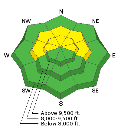
Today, there is a MODERATE avalanche danger on steep slopes facing west to north to east at mid and upper elevations where a buried persistent weak layer of faceted snow from January and February exists. This layer has gotten wet and since gained strength as it cooled and refroze, but the snow structure is still weak and it continues to deserve evaluation.
Also, look for and avoid any areas with obvious signs of wind drifted snow on all upper elevation slopes.

The remaining aspects and elevations have a LOW avalanche danger.
Low
Moderate
Considerable
High
Extreme
Learn how to read the forecast here
Special Announcements
Two generous UAC supporters are challenging the community to invest in the future of the UAC’s forecasting program during the 2022 Spring Campaign. They will match your donation, dollar for dollar, up to $10,000.
Weather and Snow
This morning, mountain temperatures range in the low to mid-20s F. Winds at most ridgelines have shifted from northwesterly to southwesterly and are blowing 5-10 and gusting 15 mph. Winds at the highest elevations are blowing 10 mph gusting 20 mph.
Today, A quick-moving system will bring light snow accumulations to the mountains of northern Utah. Another round of isolated thunderstorms is possible this afternoon and evening. There is the potential for a period of graupel with these thunderstorms. Clearing conditions can be expected later this evening. Temperatures around 8000 ft should warm into the upper 30s F while temperatures at higher elevations should warm to the mid 20s F. Winds will become west-northwesterly and increase into the afternoon and evening, blowing at speeds of 10-20 mph with gusts up to 35 mph at the highest ridgelines. We could get 1-4" of new snow by tomorrow morning.
Snow conditions: A variety of snow surfaces should exist in the backcountry this morning. The key today is to gain elevation where temperatures are colder, and the new snow may have remained dry yesterday. Even though the snowpack is insulated by a blanket of new snow, it should be refreezing again this morning. You'll know by how far your feet sink into the snow if it's refrozen or not.

Recent Avalanches
Last weekend's record heat caused many wet avalanches and reports continue to trickle in.
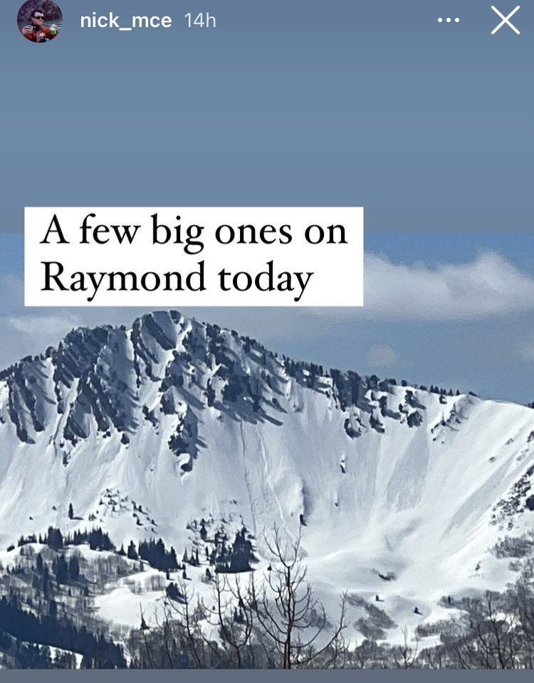
Yesterday there was some wet activity reported on the face of Raymond Peak through Instagram. Ski resorts also reported some small wet loose activity in the afternoon.
Photo of Raymond wet activity.
Ad
Avalanche Problem #1
Persistent Weak Layer
Type
Location
Likelihood
Size
Description
What happened to the buried persistent weak layer of facets (1-3' deep) that formed during the long dry period in January and February? Yesterday, both Greg and I were in Upper Cottonwoods and were still able to find this layer at the mid and upper elevations. While this layer has become noticeably wet during the record heat this past weekend, the structure is still very weak and as it has been unable to fully cool quite yet.
Over the past few days, this weak layer received a relatively heavy load of snow that is now putting stress on it, and I'm not ready to blindly trust this layer. I think that we are trending in the right direction and this layer is beginning to stabilize with every night of cooler temperatures, but until the temperatures drop consistently and this layer properly refreezes, I will continue to be suspect of the mid and upper elevation slopes facing west to north to east.
What to do? Over the next few days, I would continue to evaluate and look for the layer while out traveling. We want to start watching the trend, and seeing if this layer is truly beginning to stabilize. I would continue to perform numerous extended column tests and hand hardness tests to see if this layer is getting harder to push my hand into, and truly refreezing overnight.
Video from my field day in Upper Big Cottonwood Canyon yesterday.
Avalanche Problem #2
Wind Drifted Snow
Type
Location
Likelihood
Size
Description
With a few inches of new snow slated for this afternoon, even a small bump in winds will begin drifting snow. Over the past 24 hours winds have blown from the north, south, and now west. Elevated winds, from any direction, can deposit snow around terrain features on almost any aspect, this is called cross-loading. For this reason, I would expect to find slabs of wind drifted snow on all upper elevation slopes, especially along with terrain features such as ridgelines, sub ridges, and gullies.
Today look for slopes with any signs of wind drifted snow, such as cracking, hollow noises, and pillow-shaped snow, and avoid those slopes.
Additional Information
A related problem to wet avalanches are glide avalanches which happen in places where the snowpack rests on a smooth surface like a rock slab (places like Stairs Gulch, Broads Fk, and Mill B South of Big Cottonwood Canyon). When liquid water reaches the bottom of the snowpack, a glide crack opens as the entire snowpack moves downhill until at a random time it releases catastrophically producing a glide avalanche. One was observed this weekend in Broads Fork, and I won't be surprised to hear of more happening during any large temperature bump.
General Announcements
Who's up for some free avalanche training? Get a refresher, become better prepared for an upcoming avalanche class, or just boost your skills. Go to https://learn.kbyg.org/ and scroll down to Step 2 for a series of interactive online avalanche courses produced by the UAC.
This information does not apply to developed ski areas or highways where avalanche control is normally done. This forecast is from the U.S.D.A. Forest Service, which is solely responsible for its content. This forecast describes general avalanche conditions and local variations always occur.