Donate to the 2024 Spring Campaign to help rebuild the UAC website.

Forecast for the Salt Lake Area Mountains

Mark Staples
Issued by Mark Staples for
Tuesday, March 29, 2022
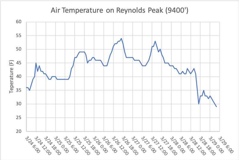
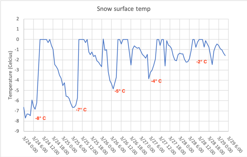
What a mess of conditions today! There is rain/drizzle and a wet snowpack at low elevations. Mid elevations have cooled but the snowpack likely remains mostly damp or wet and have a buried persistent weak layer that hasn't gone away. Higher up the snow surface refroze last night and now has an inch or two of new snow that will be drifted by increased winds this afternoon. The danger is MODERATE at all elevations and aspects because avalanches remain possible
If conditions sound complex, they are. After such hot weather this weekend, the snowpack remains wet in many places. Even though the snow surface refroze last night at mid elevations, the snow is likely wet underneath. To make matters more confusing and tricky, some slopes still harbor a buried layer of weak facets, and we don't know yet if this layer has begun healing or if it remains unstable. Most all of the avalanche problems are difficult to evaluate today.
Personally, I'd just avoid all avalanche terrain today because there's a lot of risk and uncertainty but little reward.
Low
Moderate
Considerable
High
Extreme
Learn how to read the forecast here
Special Announcements
Two generous UAC supporters are challenging the community to invest in the future of the UAC’s forecasting program during the 2022 Spring Campaign. They will match your donation, dollar for dollar, up to $10,000.
Weather and Snow
Current weather: Last night, temperatures finally dropped below freezing at elevations above 9000'. This morning upper elevation temperatures are in the mid 20s F, mid elevations are hovering just below freezing, and low elevations are in the low to mid 30s F. Winds this morning are blowing 5-12 mph with a few higher gusts generally from the west. The rain/snow line appears to be around 8000' this morning with 1-2 inches of snow above that and a little drizzle of rain below that elevation.
Today's weather: Temperatures may climb a few degrees today especially at lower elevations and may remain in the mid to upper 20s F up high. By mid morning, winds should shift and blow from the northwest and increase to 20-30 mph by this afternoon. Snow will fall on and off through the day with the rain/snow line hovering near 8000'. There should be brief periods of heavy snowfall and possibly some lightning. 2-4 inches of snow should fall today with a few more falling overnight.
Snow conditions: I don't know what to say about the snow except it's a mixed bag of conditions. It's likely wet and unsupportable at low elevations. The snow surface at upper elevations refroze and has 2 inches of new snow on top this morning. Mid elevations refroze on the surface but likely have wet to damp snow underneath.
Image below shows air temperatures on Reynolds Peak (9400') in Big Cottonwood Canyon which finally saw temperatures finally drop below freezing early this morning.
Recent Avalanches
Over the last four days or so there has been notable wet snow avalanche activity, with some wet slabs and plenty of wet loose avalanches. Most of the avalanche activity was naturally triggered by the heat. With such warm weather, some avalanches even occurred at night when the snowpack didn't refreeze and still had liquid water percolating down through it. Check out the full list of reported avalanches HERE but I'm not sure we captured all of them as there just weren't too many people in the backcountry.
Ad
Avalanche Problem #1
Wet Snow
Type
Location
Likelihood
Size
Description
Air temperatures finally dipped below freezing last night at elevations above 9000' after about 5 days without below freezing temps. The snow at mid and low elevations remains mostly wet and should remain so today especially with some rain falling at low elevations today. Mostly I expect wet loose avalanches at low elevations. What scares me more is the possibility of a wet slab avalanche at mid elevations mostly on north and east aspects with a buried persistent weak layer of facets (1-3 ft deep) that is likely wet or damp and unstable. I don't like it and I wouldn't trust the snowpack today.

The most unpredictable avalanches of all are glide avalanches which happen in places where the snowpack rests on a smooth surface like a rock slab (places like Stairs Gulch, Broads Fk, and Mill B South of Big Cottonwood Canyon). When liquid water reaches the bottom of the snowpack, a glide crack opens as the entire snowpack moves downhill until at a random time it releases catastrophically producing a glide avalanche. One was observed this weekend in Broads Fork, and I won't be surprised to hear of more happening.
The snowpack has a lot of heat in it still. Below is a graph of snow surface temperatures at the Atwater Plot over the last five days. Snow can't get warmer than 0°C but you can notice the gradual warming as heat each day was added to the snowpack. It will take a number of days for the snow to cool and totally refreeze.
Avalanche Problem #2
Persistent Weak Layer
Type
Location
Likelihood
Size
Description
There's still a buried persistent weak layer of facets 1-3 feet deep. It is likely wet or damp in most places as Drew found yesterday on Gobblers Knob (photo below). At upper elevations, this layer has a pockety distribution but may remain dry and weak.
I'm just really uncertain of the exact state of this layer today and wouldn't trust it. Where it became damp or wet, it may gain strength in coming days if it refreezes. I suspect there are a few pockets at the highest elevations where it remains dry and could produce a slab avalanche in coming days espeically as it gets loaded by new snow.
Avalanche Problem #3
Wind Drifted Snow
Type
Location
Likelihood
Size
Description
Snow falling today may be transported by increased winds from the north and northwest late today. Watch for a few soft slabs of wind drifted snow under ridgelines and other terrain features.
General Announcements
Who's up for some free avalanche training? Get a refresher, become better prepared for an upcoming avalanche class, or just boost your skills. Go to https://learn.kbyg.org/ and scroll down to Step 2 for a series of interactive online avalanche courses produced by the UAC.
This information does not apply to developed ski areas or highways where avalanche control is normally done. This forecast is from the U.S.D.A. Forest Service, which is solely responsible for its content. This forecast describes general avalanche conditions and local variations always occur.