Forecast for the Salt Lake Area Mountains

Greg Gagne
Issued by Greg Gagne for
Monday, March 28, 2022
The avalanche danger is CONSIDERABLE at all aspects and elevations due to recent and continued warming of the snowpack. Natural avalanches are possible and human-triggered avalanches are likely. Avoid being in avalanche paths and below avalanche runout zones.
Low
Moderate
Considerable
High
Extreme
Learn how to read the forecast here
Special Announcements
Two generous UAC supporters are challenging the community to invest in the future of the UAC’s forecasting program during the 2022 Spring Campaign. They will match your donation, dollar for dollar, up to $10,000.
Weather and Snow
Temperatures range through the upper 30's and low 40's F and south winds are increasing - averaging in the teens with gusts in the 30's at mid elevations and gusting over 80 mph at 11,000'.
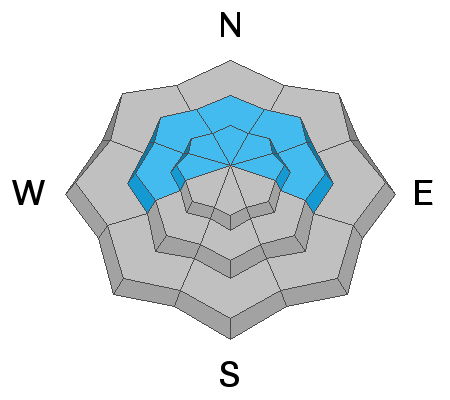
For today, cloudy skies and moderate to strong southerly winds gusting into the 30's and 40's mph along exposed mid-elevation ridges with gusts in the 60's and 70's (possibly stronger) along the upper-most ridges. Temperatures will rise into the 40's F. Showers (that is, snow above 9,000' with light rain below that elevation) are possible by late in the day.
The strong southerly winds are ahead of a spring storm system that arrives later today and last through Wednesday, bringing 4-8" of dense snow and cooler temperatures.
Recent Avalanches
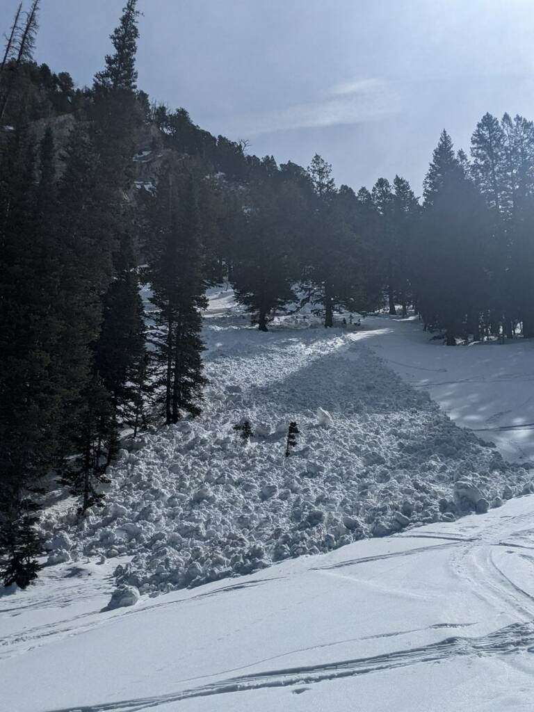
Over the past three days there have been several large natural avalanches including East Kessler (with avalanche debris covering the summer road), Ivory Slabs, Porter Slabs (photos below), and along the Park City ridgeline. Snow safety teams at resorts have reported natural wet avalanches during the overnight hours. We also received several observations from folks climbing in Little Cottonwood Canyon of avalanches occurring on the north-facing avalanche paths on the opposite side of the canyon including Perla's Ridge and The Y Couloir.
Ad
Avalanche Problem #1
Wet Snow
Type
Location
Likelihood
Size
Description
It has been roughly 100 hours (4 days) since most mountain locations have had below-freezing temperatures with another day of warm temperatures ahead. Cloud cover, winds, and slightly cooler temperatures today should mean less warming, but the snowpack remains warm and wet with meltwater moving down through the snowpack. As this water trickles down, it loosens (weakens) the bonds, creating a weak snowpack structure where both natural and human-triggered avalanches can occur.
These wet avalanche types include:
  • Wet Loose avalanches are likely on all aspects and elevations and may subsequently trigger wet slabs.
  • Wet Slab avalanches are possible on many aspects and elevations, especially on steep northeast to southeast facing aspects. Crown depths may be 1-3' with very wide propagation.
  • Cornices are sagging and may calve off, triggering avalanches below.
At some point, glide avalanches will happen in Stairs Gulch, Broads, and Mill B South of Big Cottonwood Canyon. This photo from Saturday shows glide cracks beginning to emerge in Broads Fork.

With no overnight refreezes, the usual spring protocol of an early start doesn't apply right now and it is best to all avalanche terrain until colder temperatures lock up the snowpack.
Avalanche Problem #2
Persistent Weak Layer
Type
Location
Likelihood
Size
Description
You can still trigger slab avalanches 1-3' deep on our Jan/Feb drought layer of facets, especially on mid-to upper elevation north to northeast facing slopes. You may trigger these remotely - from a distance or from below.
General Announcements
Who's up for some free avalanche training? Get a refresher, become better prepared for an upcoming avalanche class, or just boost your skills. Go to https://learn.kbyg.org/ and scroll down to Step 2 for a series of interactive online avalanche courses produced by the UAC.
This information does not apply to developed ski areas or highways where avalanche control is normally done. This forecast is from the U.S.D.A. Forest Service, which is solely responsible for its content. This forecast describes general avalanche conditions and local variations always occur.