Forecast for the Salt Lake Area Mountains

Drew Hardesty
Issued by Drew Hardesty for
Sunday, March 27, 2022
I expect the avalanche danger to reach HIGH today on some slopes. Avoid being on or beneath steep terrain. Natural and human triggered avalanches are expected.
This is a classic HIGH RISK - LOW REWARD type of day in the backcountry with a lot of uncertainty on how things will play out. Which slopes will natural, which ones will not?
I'll repeat - Avoid avalanche paths, Avoid runout zones.
Low
Moderate
Considerable
High
Extreme
Learn how to read the forecast here
Special Announcements
Two generous UAC supporters are challenging the community to invest in the future of the UAC’s forecasting program during the 2022 Spring Campaign. They will match your donation, dollar for dollar, up to $10,000.
Weather and Snow
Record breaking temperatures at the surface and aloft, a cranky snowpack...not much good can come of this. It's rare for me to say this, but based on snow, weather, and avalanche conditions, I don't recommend skiing or riding in the backcountry this weekend.
Skies are partly cloudy. The southwest winds picked up again overnight and are blowing 15-20mph with gusts to 25. The most exposed anemometers are registering hourly averages of 30mph with gusts to 45.
Temperatures remain well above freezing with ridgetop "lows" in the low 40s. It's too much. Alta base almost hit 60°F yesterday and the base of PCMR was a sizzling 73°F. That can't be right, can it?
The "last best" refreeze was Wednesday night. Look below at the temperature trend for the Mill D North weather station in BCC. It sits at roughly 9000'.

We'll have periods of sun with high cirrus moving through overhead at times today. Winds will blow 20-25mph from the southwest. Mountain temperatures will rise to the upper 40s again up high, the low 60s down low. The Outlook: We'll see increasing clouds and southwest winds tonight into tomorrow ahead of an early week storm. Some light precipitation may begin to fall Monday night with an initial rain/snow line upwards of 9000'+. We may see 4-8" of heavy, dense snow through Wednesday.
Recent Avalanches
I received a message from Jesse Robertson at UDOT-BCC yesterday morning that East Kessler (High Pockets) had run naturally with avalanche debris piling up deeply across the summer road. Kessler Peak is the lion of mid-BCC with nearly 360° of serious avalanche terrain on its flanks. High Pockets is a steep east facing avalanche path running roughly 2000' to the Cardiff Fork creek bed below. (photos below)
This easily confirmed our fears for dangerous wet avalanche conditions in the Wasatch and by the end of the day, we heard of a few more (likely) wet slab avalanches in the backcountry:
  • Rainbow Peak (mid-White Pine of LCC) - East facing at 9600', unknown dimensions but probably 2-3' deep and 300' wide
  • Ivory Slabs (mid-Cardiff Fork of BCC) - East facing at 10,300', unknown dimentions but probably 2-3' deep and 200' wide
  • West Monitor and Dutch Draw along the PC ridgeline - Easterly facing at roughly 9400 - 'each had a cornice or wet loose that pried out something of a wet slab below
  • LCC mid-canyon north facing couloirs and gullies: appears that the Y-Couloir and gullies near Perla's naturally avalanched with wet debris
More details can be found under Observations and Avalanches in the Menu above or via this LINK


We did receive hear of an avalanche accident on the east side of 10420' (above Bloods Lake) from Friday. A skier was caught, carried, and suffered traumatic injury as he was swept through the trees. With the assistance of snowmobile guides in the area and Wasatch County SAR, he was evacuated for additional medical care. We have few other details at this time, but I suspect this avalanche was a soft slab failing on the Jan/Feb drought layer PWL of facets, northeast facing at 9700' (estimate). Photo below.
Ad
Avalanche Problem #1
Wet Snow
Type
Location
Likelihood
Size
Description
I expect more dangerous avalanches today.
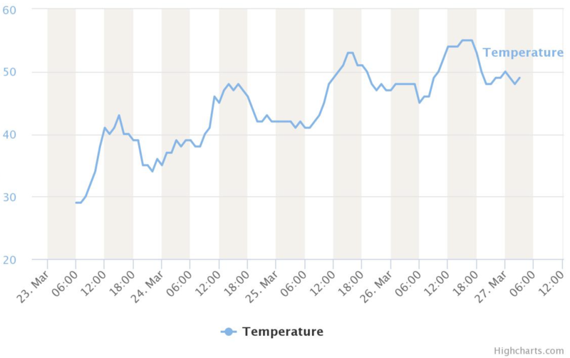
Overnight temps last night (this morning) are ridiculously warm and we may yet again break records for high temps today. This is only adding more melt water down into the snowpack, weakening and loosening the bonds holding the snow onto the slopes.
These are strange times - dealing with an unusually cranky snowpack for so late in the season and subjecting it to sustained, blistering heat and record-breaking temperatures. The melt-freeze cycle in general provides a stabilizing influence on the snowpack, but once you lose the "freeze" part of the cycle, frightful things begin to happen, particularly when the sun is beating down on the mountains during the day and you have a conditionally unstable, layered, "cranky" snowpack. The melt-water now starts to potentially pool along structural interfaces, dissolve the bonds holding the snow together, and, well, initiate avalanches.
BIG PICTURE: I am worried about the wet avalanche conditions this weekend. Some of the concerns are below.
  • Wet Loose avalanches are likely on all aspects and elevations and may subsequently trigger wet slabs below.
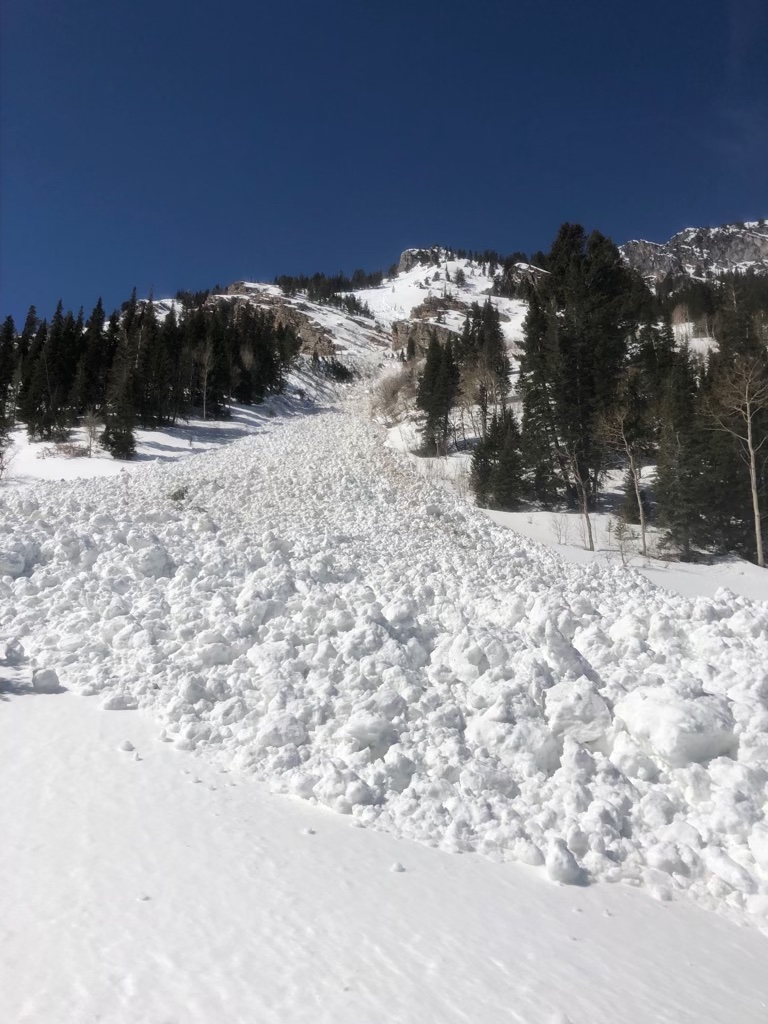
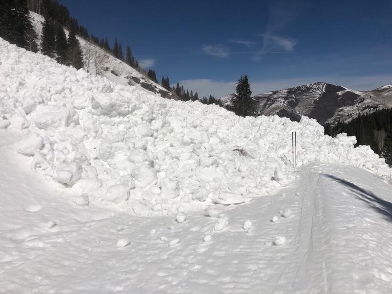
  • Wet Slab avalanches are probable on many aspects and elevations and perhaps most likely on steep northeast to southeast facing aspects. Crown depths may be 1-3' with very wide propagation.
  • Cornices are sagging and may calve off in this heat, triggering avalanches below.
  • Glide avalanches are likely in Stairs Gulch, Broads, and Mill B South of Big Cottonwood Canyon. These are drainages to avoid this weekend and early next week.
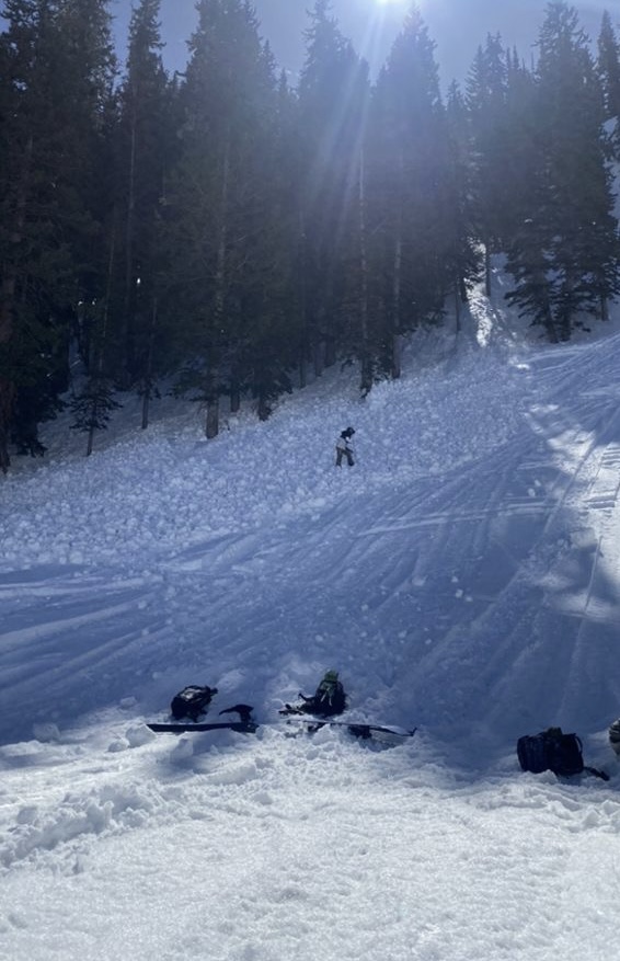
Remember that wet avalanche debris sets up immediately like concrete and difficult to excavate an avalanche victim. Glide avalanches are large and full depth and rarely survivable.
Travel Advice: Avoid avalanche paths; avoid runout zones.
Avalanche Problem #2
Persistent Weak Layer
Type
Location
Likelihood
Size
Description
You can still trigger warm and damp soft slab avalanches 1-3' deep on our Jan/Feb PWL drought layer of facets, notably on mid-to upper elevation north to northeast facing slopes. You may also trigger these from a distance or from below. Certainly the slab and weak layer is changing with the heat, but the structure is still poor and conditionally unstable.
General Announcements
Who's up for some free avalanche training? Get a refresher, become better prepared for an upcoming avalanche class, or just boost your skills. Go to https://learn.kbyg.org/ and scroll down to Step 2 for a series of interactive online avalanche courses produced by the UAC.
This information does not apply to developed ski areas or highways where avalanche control is normally done. This forecast is from the U.S.D.A. Forest Service, which is solely responsible for its content. This forecast describes general avalanche conditions and local variations always occur.