Forecast for the Salt Lake Area Mountains

Trent Meisenheimer
Issued by Trent Meisenheimer for
Sunday, March 26, 2023
Today the avalanche danger is CONSIDERABLE across all aspects and elevations where human-triggered avalanches are likely. Heavy snowfall and strong winds over the past few days have created a layered and unstable snowpack. Careful snowpack evaluation, cautious route-finding, and conservative decision-making will be essential today.
Low
Moderate
Considerable
High
Extreme
Learn how to read the forecast here
Special Announcements
Thank you to everyone who donated to our Spring Campaign. We appreciate your support and look forward to creating new tools to help you stay safe in the backcountry.
Weather and Snow
Under mostly cloudy skies, the mountain temperatures are frigid, with many stations hovering around 0°F. Wind chills range from -10 to -25°F. Winds are blowing from the west and have finally relaxed, blowing 10-15 mph across the upper elevations. Some anemometers are hardly moving. In the past 24 hrs, we've picked up the last few inches of snowfall (0.12 water) from a record-breaking week, with snow totals since Monday pushing 2-5 feet of snow (2.76-5.85 inches of water).
Today we will see another small shortwave trough move overhead that will lead to increasing clouds and convective snow showers this morning and afternoon, and we may see an additional 2-4 inches of new snow throughout the day. Depending on your location, it's possible that you will see sunshine coming through the broken clouds. However, temperatures will remain cold, with daytime highs ranging from 13-17 °F. Winds will oscillate generally from the west direction, blowing at speeds of 10-20 mph across the upper elevations.
Recent Avalanches
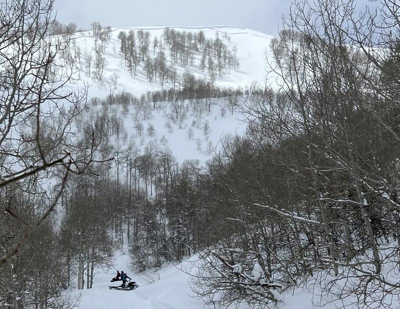
Avalanche activity and reports of natural avalanches continue to pour into the observation queue, and I recommend spending a few minutes reading all the observations. The few that caught my attention were Ant Knolls and an avalanche reported from Neffs Canyon (reported via email).
The Ant Knoll's avalanche was remotely triggered 2 feet deep and 700 feet wide (pic below). The other avalanche in Neffs Canyon was on an NW facing slope at 9,400' and was triggered while the group transitioned to downhill mode and was 2-3 feet deep, unknown width, and ran 1,000 feet downhill. Other reports of collapsing, cracking, and extended column tests propagating across the column have me taking a few steps back for now.
Ad
Avalanche Problem #1
Wind Drifted Snow
Type
Location
Likelihood
Size
Description
Over the past few days, relentless winds from the west and northwest have loaded many slopes with additional heavy, dense snow. The Ant Knolls avalanche is the perfect example of a wind-drifted slope that avalanched. These avalanches could be 1-3 feet deep and several hundred feet wide that fail on various layers (read new snow problem) within the snowpack. Today is not the day to mess with any steep slope (greater than 30°) that the wind has loaded.
Avalanche Problem #2
New Snow
Type
Location
Likelihood
Size
Description
Over the past few weeks, our mountains have continued to receive recorded-breaking snowfall. As a result, these different storms have created a very layered snowpack, and I think there are three ways an avalanche can be triggered today:
  • Avalanches could fail within the new storm snow (density changes) within the storm snow.
  • Avalanches could fail at the old/new snow interface, now buried roughly 2-5 feet deep.
  • Avalanches could also fail deeper into the snowpack on many different layers such as: sun crusts, rain crusts, wind crusts, graupel layers, and in some cases, slightly weaker faceted snow.
The issue is I have no clue which one of these layers an avalanche could fail on. Backcountry observers continue to report collapsing, cracking, and propagation within their extended column tests across all elevations and aspects. Don't be fooled into thinking this is just an upper elevation problem. This problem exists from the mountain peaks to the valley floor as seen in Provo with plenty of activity below 8,000'.
Avalanche Problem #3
Wet Snow
Type
Location
Likelihood
Size
Description
The wild card: It's almost April, and that sun is strong. Any periods of strong sunshine could instantly spike the avalanche danger, and wet snow avalanches could happen. My hunch is the cold temperatures and scattered clouds will be enough to keep wet activity at bay. However, always be on the lookout for wet snow if the sun comes out this time of year.
General Announcements
This information does not apply to developed ski areas or highways where avalanche control is normally done. This forecast is from the U.S.D.A. Forest Service, which is solely responsible for its content. This forecast describes general avalanche conditions and local variations always occur.