Forecast for the Salt Lake Area Mountains

Greg Gagne
Issued by Greg Gagne for
Friday, March 17, 2023
The avalanche danger is CONSIDERABLE at the upper elevations and MODERATE at the mid elevations where you can trigger avalanches failing in dense slabs of recent storm snow and wind-drifted snow. These wind drifts may allow you to get well onto a slope before fracturing.
Today's strong sunshine will increase the risk of wet, loose avalanches on steep slopes facing southeast through west.

Roof-a-lanches in our mountain communities are a hazard this season. Do not let children play in the snow underneath steep roofs loaded with snow.
Low
Moderate
Considerable
High
Extreme
Learn how to read the forecast here
Special Announcements
Please consider donating to the spring campaign to help our team implement innovative tools to better provide you with the information you rely on.
Weather and Snow
This morning: Skies are clear and temperatures are in the single digits and low teens F. Winds are easterly and light, less than 10 mph, gusting into the teens at the upper-most elevations.
Today: Sunshine. Temperatures will reach the 20's F. and the east/southeast winds will remain light.
Ahead: Keep the sunscreen handy for this weekend with sunshine and temperatures in the 20's F. The easterly winds will remain light, but begin to veer southwest later Sunday ahead of what currently appears to be an active week of snowfall.

Many southerly-facing slopes will have a crust from Thursday's sunshine.
Recent Avalanches
Thursday's clear weather provided prime-time viewing of the widespread natural avalanche cycle that occurred Wednesday and overnight into Thursday morning. You are encouraged to read through all of the recent avalanches, but the two reports that caught my mind are:
Mount Superior: Skier-triggered slide on a southeast aspect below the summit of Mount Superior on Thursday morning. The slide was from a cornice fall that was triggered by a skier along the ridge. 2' deep, 400' wide, running over 2,000' vertical.
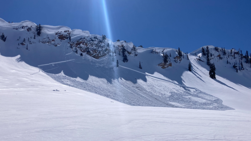
No Name Baldy in Red Pine: 3-8' deep and roughly 2,500' wide. Likely triggered by a natural cornice fall. Zinnia Wilson briefly discusses this avalanche below:

On Wednesday in the town of Alta, a child playing with a group of friends in the snow was buried underneath an avalanche that came from a steep roof above. Fortunately, through an efficiently-organized recovery effort, the child was dug out and survived. These are appropriately called "roof-a-lanches" and will remain a hazard in our mountain communities this Spring. Do not let children play in the snow underneath steep roofs filled with snow. Please share this message.
Ad
Avalanche Problem #1
Wind Drifted Snow
Type
Location
Likelihood
Size
Description
You can find wind-drifted snow on all aspects at the upper elevations, as well as some mid-elevation slopes. Although these wind drifts are becoming less sensitive, my field work from yesterday - as well a few human-triggered avalanches - indicates these wind drifts need a bit more time to settle out and I would continue to avoid steep, wind-drifted slopes.

CORNICES are huge and may become sensitive to the strong sunshine. Give cornices a wide berth as they often break farther back than expected. Cornices are signs that a slope has been wind loaded and a cornice fall could trigger a larger slab of wind-drifted snow below, as shown in this photo from Thursday in Cardiff Fork:
Avalanche Problem #2
Wet Snow
Type
Location
Likelihood
Size
Description
Storm snow from Tuesday and Wednesday took on strong sunshine on Thursday, so in theory the new snow has adjusted to the warming. But that's in theory, and another day of strong sunshine and light winds may create additional wet loose avalanches today. Watch for signs of reactive wet snow such as rollerballs. All you will have to do today to avoid wet snow issues (and find better snow quality!) is to add a touch of north to your slope where you'll find softer and drier snow.
Additional Information
We strive to understand patterns or hints of patterns with the snowpack and with avalanches to make a coherent assessment...and sometimes things aren't as clean cut as we would like. Forecaster Dave Kelly put some thoughts down on paper. His essay Early Morning Pattern Hunting-What's the Problem? is worth the read.
General Announcements
This information does not apply to developed ski areas or highways where avalanche control is normally done. This forecast is from the U.S.D.A. Forest Service, which is solely responsible for its content. This forecast describes general avalanche conditions and local variations always occur.