Sign Up for the Utah Snow and Avalanche Workshop (USAW) on December 7th!

Forecast for the Salt Lake Area Mountains

Nikki Champion
Issued by Nikki Champion on
Thursday morning, March 16, 2023
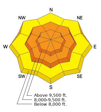
The avalanche danger is CONSIDERABLE at all upper and mid-elevation slopes where heavy snowfall and strong winds have created dangerous avalanche conditions. Freshly formed wind drifts, and both soft slab and dry loose avalanches within the new snow are the main avalanche problems today.
Practice safe travel techniques, exposing only one person at a time, and choosing low-angle terrain with nothing steep above.

With multiple days of strong winds, and recent rainfall cornices and roof avalanches will remain a concern today.
Low
Moderate
Considerable
High
Extreme
Learn how to read the forecast here
Special Announcements
The UAC is currently working with the operation involved in Thursday's fatal avalanche in the Uintas to prepare a report. Please be patient as we sort out the details of this complicated incident. A preliminary report is available HERE.

Please consider donating to the spring campaign to help our team implement innovative tools and better provide you with the information you rely on.
Weather and Snow
This morning, there are a few clouds in the sky and a final few flakes could be falling in the mountains. Temperatures dropped significantly since yesterday morning, sitting in the single digits to mid-teens F. Overnight the mountains received a trace amount of snow. Bringing snow totals for the Central Wasatch between 10-20" of snow (1.30-2.30 of water). Yesterday, winds transitioned from the Southwest to the Northwest. At the 9000' ridgelines winds are currently blowing at speeds of 10-15 mph with gusts up into the mid-20s mph. At the 11,000' ridgelines, winds are gusting close to 35 mph.
Today, we get a rare period of generally quiet weather. Skies will be partly cloudy, with the chance for a light snow shower this afternoon. No more than a trace amount of snowfall accumulation. Winds will remain from the Northwest, blowing 10-20 mph with gusts up to 25 mph at 9000' ridgelines. At the 11,000' ridgelines, we could see gusts up to 40 mph.
Weather remains active. Another long-duration storm is expected early next week, this potential atmospheric river event should bring a lower rain/snow line than the last two.
Recent Avalanches
Yesterday was an active day in the backcountry. We had reports of natural wet-loose activity in the lower elevation bands, and both natural and human-triggered soft slabs of new snow and wind-drifted snow in the mid and upper-elevation bands.
Lanes leap, a reoccurring indicator slope in upper Big Cottonwood Canyon. A natural soft slab of wind-drifted snow at 9,600' on a north-facing aspect that failed on faceted grains 2' deep. (B. Nalli)
Ski resorts also reported widespread soft slabs of both wind-drifted snow and new snow, reactive to both explosives as well as skis.
There was also a close call with a roof avalanche, remember with so much snow on rooftops in mountain communities, roof avalanches will be a significant hazard as the sun warms roofs in mountain neighborhoods. Children playing and adults shoveling solo are especially vulnerable to this hazard.

Get all observations HERE.
Ad
Avalanche Problem #1
Wind Drifted Snow
Type
Location
Likelihood
Size
Description
Due to the elevated winds that have accompanied this front, you'll likely find sensitive slabs of wind-drifted snow at the upper elevations, and some mid-elevation sub-ridges as well. Winds had been primarily blowing from the south, and southwest over the last few days, but transitioned north, northwesterly yesterday. For this reason, one could find drifting on all aspects.
Look for cracking, collapsing, and rounded pillows of new snow, and avoid steep terrain where you could trigger them.
These wind-drifted snow avalanches may entrain the new snow and on steeper slopes will be more than enough to take a rider off their feet.

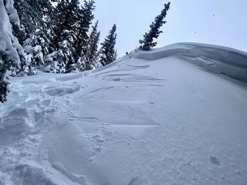
CORNICES are currently large and growing and may be particularly sensitive and tender during periods any periods of broken sun today. Give cornices a wide berth as they often break farther back than expected. Cornices are signs that a slope has been wind loaded and a cornice fall could trigger a larger slab of wind-drifted snow below.
Avalanche Problem #2
New Snow
Type
Location
Likelihood
Size
Description
Out of the wind zone you can expect to find sensitive soft slabs of new snow and fast, long-running sluffs on all aspects at mid and upper elevations.
Use caution and watch for easily triggered new snow avalanches while ascending and descending steep slopes. Travel one at a time through steep terrain over 30 degrees and think about not IF you'll see a new snow avalanche, but where it might take you if swept off your feet.
Watch for signs of instability such as cracking and sluffing.
The cooler temperatures and broken clouds should keep wet snow at bay, but if you find yourself in steep, sunlit terrain today, keep an eye on the snow surface. If you start seeing signs that the snow surface becoming damp and unsupportable, it's time to re-evaluate your terrain and change your aspect to a cooler, more shady slope.
Additional Information
We strive to understand patterns or hints of patterns with the snowpack and with avalanches to make a coherent assessment...and sometimes things aren't as clean cut as we would like. Forecaster Dave Kelly put some thoughts down on paper. His essay Early Morning Pattern Hunting-What's the Problem? is worth the read.
General Announcements
This information does not apply to developed ski areas or highways where avalanche control is normally done. This forecast is from the U.S.D.A. Forest Service, which is solely responsible for its content. This forecast describes general avalanche conditions and local variations always occur.