Forecast for the Salt Lake Area Mountains

Trent Meisenheimer
Issued by Trent Meisenheimer on
Sunday morning, February 22, 2026

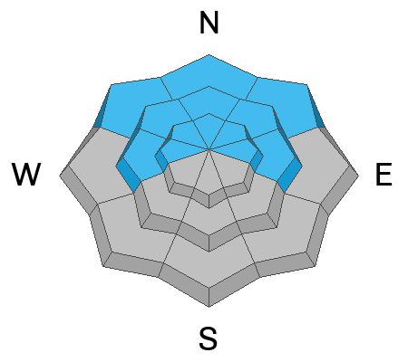
The avalanche danger is CONSIDERABLE, and today is NOT the day to be in steep avalanche terrain. That means staying off of — and out from under — slopes steeper than 30 degrees. Large, destructive, and potentially deadly slab avalanches are likely.

Blue skies and fresh powder can make it feel like a perfect day, but when those line up with dangerous avalanche conditions and busy backcountry traffic, that’s often when we see serious accidents.

Choose low-angle terrain. Spread out. Speak up within your group. Let’s work together to make sure everyone comes home.

Low
Moderate
Considerable
High
Extreme
Learn how to read the forecast here
Special Avalanche Bulletin

What: The Utah Avalanche Center is warning of dangerous avalanche conditions across all Utah mountains this weekend. This week’s heavy snowfall and strong winds overloaded preexisting weak layers, creating a HIGH avalanche danger across the entire state. With improving weather moving in for the weekend, avalanche accidents are likely in the backcountry. There have already been two tragic avalanche fatalities this week, as well as several close calls and numerous backcountry avalanches reported.

When: In effect from 6:00 AM MST today to 6:00 AM MST Monday

Where: The mountains of Utah and southeastern Idaho.

Impacts: Dangerous avalanche conditions exist in the backcountry and will persist through the weekend. Natural avalanches are possible, and people are likely to trigger avalanches on slopes steeper than 30 degrees. Dangerous and deadly avalanches can be triggered remotely (from a distance or from below). People leaving ski area boundaries are entering the backcountry where the same dangerous avalanche conditions exist.

Warning Times: Friday, February 20, 2026 – Monday, February 23, 2026 at 6:00 AM MST

Special Announcements

The UAC is deeply saddened to report two avalanche fatalities. The first occurred on Wednesday, February 18th in the Big Flat area of Snake Creek near Midway. A snowmobiler was caught, carried, and buried in an avalanche, and unfortunately, recovery efforts were unsuccessful. The preliminary report can be found HERE.

The second fatality occurred on Thursday, February 19th, in the backcountry adjacent to Brighton Ski Resort. A girl skiing was caught, carried, and buried by an avalanche and did not survive. The preliminary report can be found HERE.

Our sincerest condolences are with all those impacted. The UAC is investigating both accidents in partnership with local law enforcement.

Weather and Snow

Under clear skies this morning, mountain temperatures range from 8–25 °F. Overnight, south winds increased and continue to blow along the upper-elevation ridgelines in the 10–20 mph range. At 11,000 feet, the wind is stronger, averaging 30–35 mph with gusts into the 40s.

High pressure will be the dominant weather feature today and will persist through Monday. Expect plenty of sunshine with periods of high thin clouds drifting overhead. Mountain temperatures will climb into the mid to upper 30s °F this afternoon.

Recent Avalanches

Yesterday we received 18 avalanche observations — a mix of natural avalanches from the recent storm and human-triggered slides. There were several close calls. Three people were caught and carried in avalanches, two of whom were fully buried. All three were injured.

The Utah Avalanche Center will head to Butler Basin to investigate the avalanche that fully buried two riders. We will also visit Day’s Fork, where a snowboarder was caught, carried, and injured in a separate avalanche.

Snow safety teams reported triggering large avalanches with explosives, 2–4 feet deep and several hundred feet wide. In every case, these avalanches are failing on our Dry January layer of weak, faceted snow.

Photo: Slab avalanche in Butler Basin that fully buried two.

Avalanche Problem #1
Persistent Weak Layer
Type
Location
Likelihood
Size
Description

On slopes facing the shady half of the compass, it will be likely to trigger large, destructive slab avalanches failing on weak, faceted snow buried 2–4 feet deep. These avalanches could break hundreds of feet wide and propagate well beyond where you trigger them.

Do not let existing tracks give you confidence. Persistent weak layers can allow multiple riders on a slope before one person hits the wrong spot. These are high-consequence bone-breaking avalanches — the kind that catch, carry, and kill humans.

My advice: Live to ride another day and let our snowpack settle out.

Avalanche Problem #2
Wind Drifted Snow
Type
Location
Likelihood
Size
Description

Overnight, southerly winds increased and are now blowing at moderate speeds. It’s unclear whether they’re strong enough to form fresh drifts, but this is the mountains — always keep an eye out for active wind drifted snow.

Approach avalanche terrain with caution. Watch for signs of wind-drifted snow such as smooth, rounded pillows, growing cornices, and cracking around your skis, board, or sled.

Avalanche Problem #3
Wet Snow
Type
Location
Likelihood
Size
Description

I’m not completely certain that temperatures and sunshine will be enough to produce wet snow avalanches today. However, the sun angle is high, and mountain temperatures are about 20 degrees warmer this morning compared to this time yesterday.

If you’re traveling in steep, sunlit terrain, keep an eye out for rollerballs and other signs of wet snow instability. Don’t overstay your welcome — when the snow surface becomes damp and sloppy, it’s time to move to cooler aspects or head home.

General Announcements

This information does not apply to developed ski areas or highways where avalanche control is normally done. This forecast is from the U.S.D.A. Forest Service, which is solely responsible for its content. This forecast describes general avalanche conditions and local variations always occur.