Forecast for the Salt Lake Area Mountains

Nikki Champion
Issued by Nikki Champion on
Friday morning, February 20, 2026

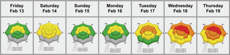
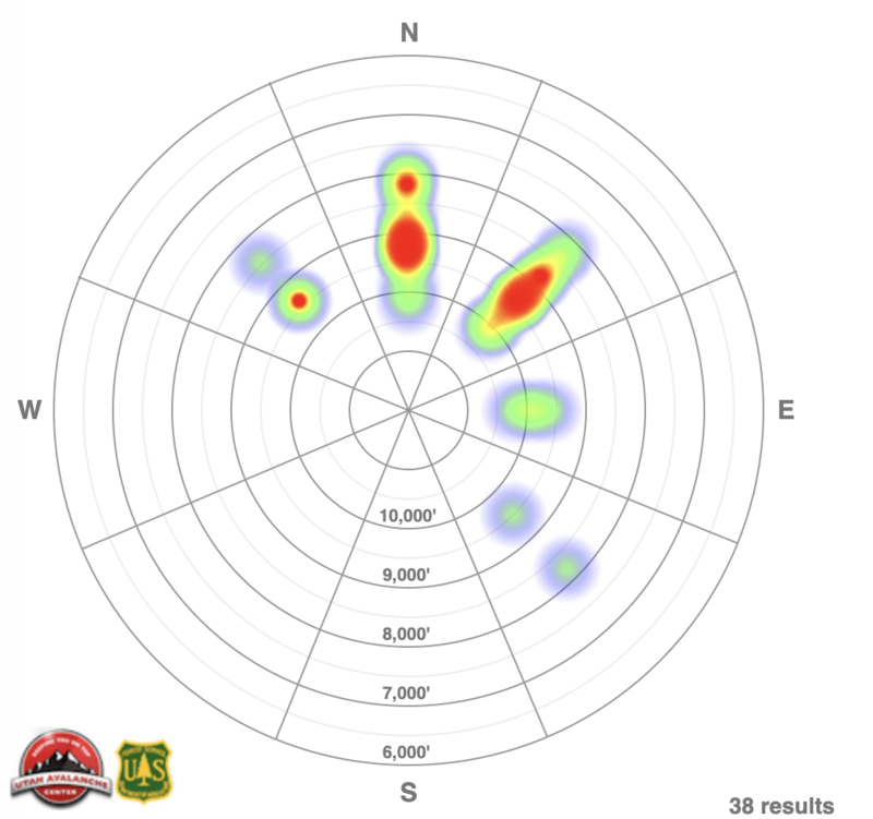
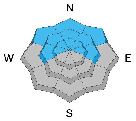
The avalanche danger is HIGH on upper- and mid-elevation slopes facing northwest through north and east. Recent snowfall and strong winds have created very dangerous conditions. Avalanches triggered in wind-drifted or new snow could step down more than 4 feet into weak-faceted snow, producing large, dangerous, and potentially deadly slides.

In just two days, we have experienced two devastating avalanche fatalities affecting parents, children, and the broader community. These are huge red flags, and we need to slow down and rethink our choices.

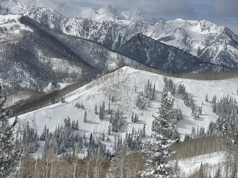
Most accidents and fatalities happen after peak instability. Let’s not add to that number going into this weekend. Return home safely at the end of the day. Avalanche terrain can be avoided, and excellent riding is available on lower-angled slopes. Remember, once you leave a ski resort boundary, you are in the backcountry.

Advice is simple today: stick to slopes less than 30 degrees, stay well away from slopes connected to or below anything steeper than 30 degrees, and be aware of who is above and below you.

Low
Moderate
Considerable
High
Extreme
Learn how to read the forecast here
Special Avalanche Bulletin

What: The Utah Avalanche Center is warning of dangerous avalanche conditions across all Utah mountains this weekend. This week’s heavy snowfall and strong winds overloaded preexisting weak layers, creating a HIGH avalanche danger across the entire state. With improving weather moving in for the weekend, avalanche accidents are likely in the backcountry. There have already been two tragic avalanche fatalities this week, as well as several close calls and numerous backcountry avalanches reported.

When: In effect from 6:00 AM MST today to 6:00 AM MST Monday

Where: The mountains of Utah and southeastern Idaho.

Impacts: Dangerous avalanche conditions exist in the backcountry and will persist through the weekend. Natural avalanches are possible, and people are likely to trigger avalanches on slopes steeper than 30 degrees. Dangerous and deadly avalanches can be triggered remotely (from a distance or from below). People leaving ski area boundaries are entering the backcountry where the same dangerous avalanche conditions exist.

Warning Times: Friday, February 20, 2026 – Monday, February 23, 2026 at 6:00 AM MST

Special Announcements

The UAC is deeply saddened to report two avalanche fatalities. The first occurred on Wednesday, February 18th in the Big Flat area of Snake Creek near Midway. A snowmobiler was caught, carried, and buried in an avalanche, and unfortunately, recovery efforts were unsuccessful. The preliminary report can be found HERE.

The second fatality occurred on Thursday, February 19th, in the backcountry adjacent to Brighton Ski Resort. A girl skiing was caught, carried, and buried by an avalanche and did not survive. The preliminary report can be found HERE.

Our sincerest condolences are with all those impacted. The UAC is investigating both accidents in partnership with local law enforcement.

Weather and Snow

Since Monday evening, an impressive series of storms has moved through the state. Yesterday was the first real break in the system, with clear to broken skies that finally let everyone see the 20 to 50 inches of new snow that had fallen. Overnight, clouds moved back in, and as a system brushed south of us, temperatures dropped into the single digits. Winds transitioned to the south and southeast and remained generally light, and an additional trace to 2 inches of new snow fell overnight.

This morning, low-density snow is falling in the mountains, likely bringing another 1 to 1.5 inches. Temperatures will climb into the mid teens and low 20s F. Winds will gradually shift more northwesterly and pick up a bit, gusting up to 20 mph along the ridgelines and up to 40 mph on the highest peaks. Snowfall totals for this entire system have been downgraded to about 3 to 6 inches for the Central Wasatch.

With a lot of new snow and clearing weather, be aware of roof avalanches in mountain communities. This is especially important for children and pets.

To review the change in weather and impressive storm, find the most recent Week in Review:

Recent Avalanches

How do you even begin to describe the avalanche activity? In just two days, our area has seen two tragic accidents, and we recorded an additional 40 avalanches in the Salt Lake zone. That is only what has been reported, processed, and entered. The true number is almost certainly higher. The vast majority were soft slabs, with a few larger hard slab avalanches and very limited dry loose activity.

Most of these avalanches broke 2 to 3 feet deep on average, likely at the new snow old snow interface sitting on weak faceted grains. A few were smaller, around 10 to 20 inches deep, while several hard slabs reached up to 4 feet deep. Reported widths ranged from isolated pockets 20 to 50 feet wide to broad propagating slabs stretching 900 to 1,500 feet across. This was a widespread cycle. Below are just a few of the standouts. Many were large and unsurvivable avalanches, but the list is long. It is worth taking the time today to read through the recent activity.

A few standouts:

  • Yellow Jacket Trees, northeast aspect at 8,800 feet on the north side of the gulch: a skier remotely triggered a 3 foot deep, 900 foot wide hard slab failing on faceted snow at the old new snow interface, producing multiple sympathetic avalanches across connected terrain.
  • West Willow Ridgeline, northeast aspect at 9,300 feet: a natural soft slab avalanche broke 2.5 feet deep and propagated roughly 1,500 feet wide, failing on faceted snow at the old new snow interface. See photo below.
  • Soldier Fork, north aspect at 8,200 feet: a skier remotely triggered a large hard slab avalanche 4 feet deep and roughly 900 feet wide, failing on faceted snow at the old new interface, removing the slab wall to wall but leaving much of the weak layer intact. A standout quote from observer, Mark White, "I’m planning on proceeding with extreme caution for the time being, being on or under any slope with the PWL and a slab on top is just looking for trouble in the near future."

Overall heat map from the Salt Lake Area mountains 2/18-2/19 as of 5AM, avalanches continue to trickle in...

Patrol teams also observed a broad natural storm cycle, with many soft slabs running during the height of the storm. Most were 2 to 3 feet deep and several hundred feet wide, with some larger D2 to D2.5 slides. A number of paths ran full track, especially in rocky and cliffy start zones. Even after the storm, remote triggers were still reported, including deeper slabs breaking 3 to 4 feet down and running long distances.

You can view all recent observations here.

Avalanche Problem #1
Persistent Weak Layer
Type
Location
Likelihood
Size
Description

The Dry January Layer (DJL), formed during our January dry spell, can be found on upper- and mid-elevation W‑N‑E facing slopes, and even on lower-elevation NW‑N‑NE terrain. This layer is responsible for much of the avalanche activity observed over the past few days.

Large slabs now exist across much of the range, resting on the very weak DJL. This strong-over-weak structure has, and will continue to, produce large, destructive avalanches. These slabs can propagate widely and may be triggered remotely from a distance.

If you’re considering “safe” travel on a ridgeline, remember that you could become a hazard to those below if you trigger, or remotely trigger, a slide on adjacent slopes, especially in busy terrain. Always be aware of who and what is above and below you. Safer riding conditions are found on slopes less than 30° with no overhead hazard.

As we move further from the initial loading event, obvious signs of instability may not be as apparent, such as cracking or collapsing, but the poor snow structure still exists. The only way to know if the weak grains remain is to stick your shovel in the snow. Even as the likelihood slowly decreases, the consequences of these types of avalanches remain extremely high. The risk is not worth the reward.

Example where Cody chats about the weak snow setup in Mineral Fork, where a large slab sits atop weak faceted grains.

Avalanche Problem #2
Wind Drifted Snow
Type
Location
Likelihood
Size
Description

Winds have been moderate to strong over the past few days. Combined with nearly 50 inches of new snow available for transport, these winds have formed and will continue to form slabs of wind-drifted snow on upper- and mid-elevation slopes.

These smooth, rounded pillows of wind-drifted snow rest on the Dry January weak layer. Alone, they could catch and carry a rider, but when combined with buried weak layers, they can trigger much larger avalanches.

Stick to sheltered, lower-angle terrain out of the wind. Watch for drifts, dunes, pillows, and wind-textured surfaces as these indicate recent wind loading.

Outside the wind zone: New snow instabilities remain a concern. Pay attention to lingering storm slabs and loose dry sluffs.

General Announcements

This information does not apply to developed ski areas or highways where avalanche control is normally done. This forecast is from the U.S.D.A. Forest Service, which is solely responsible for its content. This forecast describes general avalanche conditions and local variations always occur.