Forecast for the Salt Lake Area Mountains

Trent Meisenheimer
Issued by Trent Meisenheimer for
Tuesday, February 19, 2019
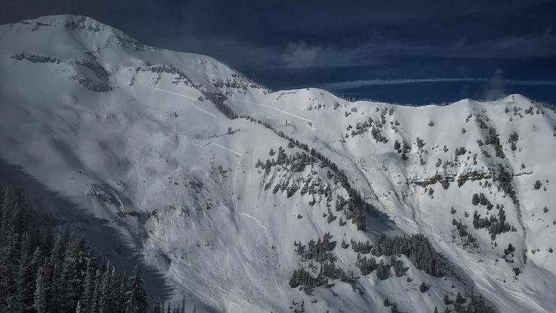
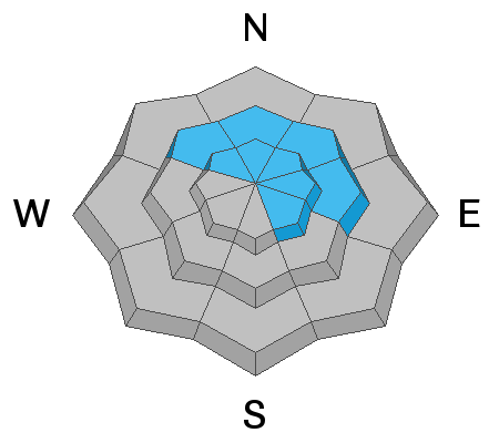
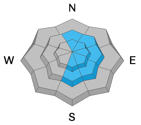
A MODERATE DANGER exists on all upper elevation wind loaded slopes for triggering new and old wind drifted slabs of snow. The danger is most pronounced on steep, upper elevation northerly through easterly facing terrain. The new snow could be sensitive to the weight of a rider and shallow soft slabs might become possible in the wind effected terrain today. Cornices are an issue - Exercise great caution along and underneath the heavily corniced ridgelines.

Safe Travel Protocols are key to successful outings: Beacon, shovel, probes, one at a time, get out of the way at the bottom, have a plan.
Low
Moderate
Considerable
High
Extreme
Learn how to read the forecast here
Special Announcements
An avalanche warning has been issues for the Abajo mountains down in southern Utah. Heavy snow and strong winds have created widespread unstable snow. If you're heading south be sure to check the Moab area specific forecasts.
Weather and Snow
Under partly cloudy skies, the northerly flow is squeezing what moisture it can out of the atmosphere. In most places a trace of new snow has fallen, while upper Little Cottonwood has picked up 6". Snow showers will linger into the afternoon before starting to clear out by mid day. The bigger headline is the cold temperatures! Upper elevation thermometers are hovering around 0°F while lower elevation trail heads are in the single digits. Winds are from the west-northwest and will continue to blow 10-15 mph with gusts into the low 20's at upper elevations today.
The skiing and riding this week has been epic to say the least. This is the classic Wasatch I can remember. Cold dry powder exists on almost every aspect. The sun did get to the southerly facing steeper terrain, where you'll find a thin zipper crust today. Mid to lower elevations 6500-8500' you'll find last Thursday's rain crust. It varies in thickness and thins as increase your elevation. Above about 8,000' it will no longer be an issue and the riding is 5 stars.
Recent Avalanches
No new avalanches were reported from the backcountry yesterday. However, this past weekend was busy with two people getting caught and carried in slides. You can view all the recent avalanche activity HERE.

In the Provo area there was a very large natural avalanche that released within the past 24 to 48hrs. This slide was 5-9' feet deep and up to 2500' feet wide, running 3,000' vertical feet to the valley floor. (PC: UDOT)
Ad
Avalanche Problem #1
Wind Drifted Snow
Type
Location
Likelihood
Size
Description
Old drifts of wind blown snow remain a concern for today. The most likely place to trigger an old lingering wind slab will be on steep, upper elevation, north through easterly facing terrain. Wind drifted snow can be highly variable, and it's typically found on leeward slopes, in gullies, open bowls, and on mid slope breaks-overs. As always, be on the look out and avoid pillowy, rounded, hollow sounding snow. These old drifts of snow are becoming more and more stable as time goes on. Many riders tested the steepest lines and couloirs throughout the Wasatch yesterday with no problems.
New drifts of wind blown snow: The northerly wind could drift the newly fallen snow onto lee aspects creating shallow and sensitive soft slabs in the wind effected terrain. Slope cuts and terrain management skills should be enough to reduce the risk of being caught in one of these smaller slides.
Avalanche Problem #2
Persistent Weak Layer
Type
Location
Likelihood
Size
Description
Our buried weak layers are becoming a thing of the past as the snowpack in the central Wasatch continues to grow. However, we can't forget Saturday's human triggered slide that failed on faceted snow. This was probably an outlier but, it's a good example of the type of terrain where it's still possible to trigger a slide that breaks into deeper weak layers. It's likely it will take a large trigger to awaken this dragon such as a cornice drop or a wind slab that steps down deeper in the snowpack. There continues to be an isolated chance that you could trigger a deeper slab avalanche. The most likely spot would be a steep, shallow, rocky slope, that faces north through east above about 9,000' in elevation.

Since February 1st we've had seven reported slab avalanches that failed into deeper weak layers. These avalanches are shown below on the heat map. All of them have been confined to north, northeast and east facing terrain above about 9,000' in elevation. These seven avalanches ranged in size from 2-8' feet deep 200-2,000' feet wide. See the avalanche list for more details HERE.
Avalanche Problem #3
Cornice
Type
Location
Likelihood
Size
Description
CORNICES ARE ENORMOUS. Most of these are too large to intentionally drop onto a slope below. They will break back farther than you think, well back from the apex of the ridgeline. Exercise great caution along and underneath the heavily corniced ridgelines.
Additional Information
The accident reports for the four avalanche fatalities are all finalized with some first-hand accounts and worth reading. We all have something to learn so that we can get home safely to our loved ones. List of all accidents found HERE.
General Announcements
This information does not apply to developed ski areas or highways where avalanche control is normally done. This forecast is from the U.S.D.A. Forest Service, which is solely responsible for its content. This forecast describes general avalanche conditions and local variations always occur.