UDOT PLANNED AVALANCHE CLOSURES!!

Forecast for the Salt Lake Area Mountains

Mark Staples
Issued by Mark Staples for
Wednesday, February 20, 2019
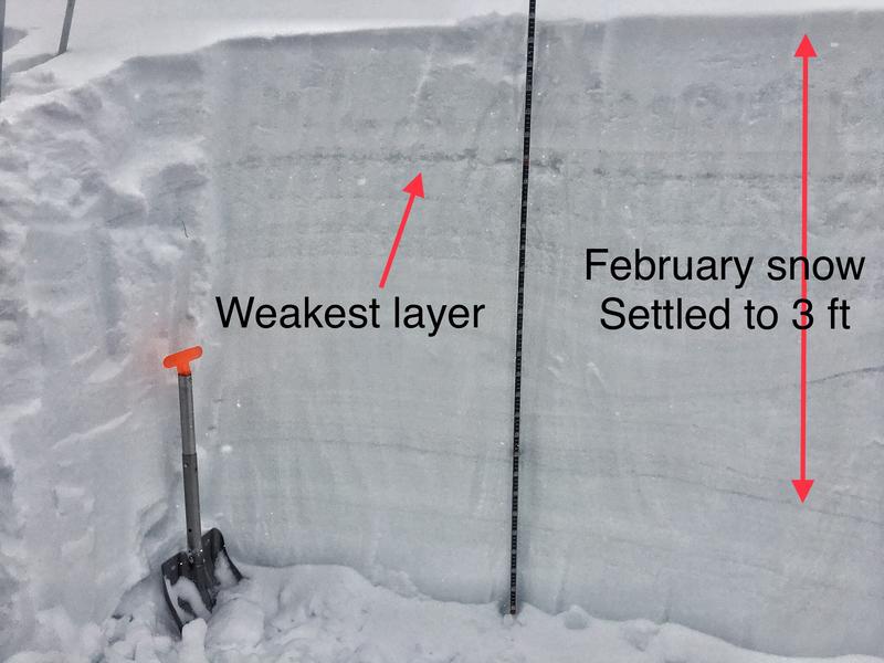
A MODERATE DANGER exists at upper elevations for triggering a soft slab of wind drifted snow. The new snow may produce soft dry sluffs as well. At mid and low elevations the danger is LOW.
Low
Moderate
Considerable
High
Extreme
Learn how to read the forecast here
Special Announcements
An AVALANCHE WATCH has been issues for the La Sal and Abajo mountains in southern Utah where the avalanche danger is expected to rise to HIGH. Strong winds with periods of heavy snow will create widespread areas of unstable snow. The avalanche danger in these mountains will remain elevated through the weekend.
Other parts of southern Utah where we don't issue avalanche forecasts may have an elevated danger as well. We do post obs from the mountains of southwest Utah. View them here or submit obs here.
Weather and Snow
Since yesterday morning 2-3 inches of very light snow has fallen.
This morning temperatures are a few degrees either side of 0 F. Winds increased since yesterday and at most ridgelines are blowing 10-15 mph gusting 20 mph from the west and southwest. At 11,000 feet winds are gusting to 45 mph.
Today snowfall will continue with another 6 inches by tomorrow morning. Temperatures today will stay cold and should struggle to reach the teens F. Winds may ease a little bit and shift a little more southerly.
There is dry, soft snow on nearly all aspects and elevations. At lower elevations and south aspects there is a crust under about a foot of snow. On northerly aspects and higher elevations, the snow is deep and soft. There have been minimal winds the last few days.
Recent Avalanches
The most recent avalanche in the Salt Lake area mountains was on February 17th. No new avalanches were reported from the backcountry yesterday.
Ad
Avalanche Problem #1
Wind Drifted Snow
Type
Location
Likelihood
Size
Description
There is plenty of fresh powder for winds to transport. Winds should easily drift this new snow and form soft slabs but this shouldn't be a widespread problem. The best way to identify and avoid these fresh slabs is to look for them. They look pillowy, rounded and smoother than freshly fallen snow. They are often found on the opposite sides of ridges or other terrain features from places where the snow is scoured.
Some faceting seems to have occurred in recent days within the top foot of snow. I found some of these weak facets about a foot deep yesterday near Gobblers and they could make any fresh slabs of wind drifted snow extra sensitive today and possibly fracture over wider than expected areas. Photo below shows this layer which allowed the new snow to sluff easily in steep terrain yesterday.
Avalanche Problem #2
Persistent Weak Layer
Type
Location
Likelihood
Size
Description
Buried persistent weak layers in the snowpack have generally gained a lot of strength and avalanche activity on faceted layers has tapered off. There is an isolated chance of a slide 2-3 feet deep breaking on facets, but this is why we (1) only expose one person at a time (2) carry rescue gear and (3) watch our partners from a safe location.

See the avalanche list for more details HERE.
Avalanche Problem #3
Cornice
Type
Location
Likelihood
Size
Description
With so much snow falling in February and lots of strong winds, cornices have grown enormous. They will break back farther than you think, well back from the apex of the ridgeline. Exercise great caution along and underneath the heavily corniced ridgelines.
Additional Information
The accident reports for the four avalanche fatalities are all finalized with some first-hand accounts and worth reading. We all have something to learn so that we can get home safely to our loved ones. List of all accidents found HERE.
General Announcements
This information does not apply to developed ski areas or highways where avalanche control is normally done. This forecast is from the U.S.D.A. Forest Service, which is solely responsible for its content. This forecast describes general avalanche conditions and local variations always occur.