Forecast for the Salt Lake Area Mountains

Drew Hardesty
Issued by Drew Hardesty on
Thursday morning, February 12, 2026

A MODERATE avalanche danger exists in the mid and upper elevations, and primarily on slopes with recent deposits of wind drifted snow. These soft slabs will be 8-18" thick and up to 150' wide and can be triggered at a distance. While pockets of soft slab exist around the compass, the most likely aspects for triggering one are on north to east facing slopes.

Low
Moderate
Considerable
High
Extreme
Learn how to read the forecast here
Weather and Snow

Skies are overcast. Temps are in the low to mid-20s up high, the low 30s down low. Winds are generally light from the west-southwest, but blowing 15-20mph along the 11,000' level. But down to brass tacks: most areas received 2-4" overnight and we can expect another 1-3" during the day today.

Storm totals below:

LCC: 10"/1.25" (Snow-water-equivalent)

BCC: 12"/1.4" SWE

PC: 8-12"/~0.8"SWE

Ogden: 4-6"/0.6-0.8"SWE

Provo: 4-6"/1.3-1.6"SWE

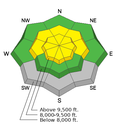
The storm arrived hot and heavy on a southwest flow with a rough rain-snow line of 7-7500'. While the mid and low elevations remain grim, the dense new snow breathed life back into skiing and riding conditions in the higher terrain. You're still bottom-feeding on the coral on the solar aspects (low angle recommended), but the polar aspects are a delight. But it comes at a cost, however: there was lots of cracking, audible collapsing and sensitive and remotely triggered soft slabs. More below.

For today, we'll have off and on snow showers that may add up to 1-3" in favored terrain. Temps will be a touch cooler than yesterday and winds will be generally light from the southwest. We should have some clearing tomorrow through the early part of the weekend before the next series of storms arrive later Sunday into Monday.

Recent Avalanches

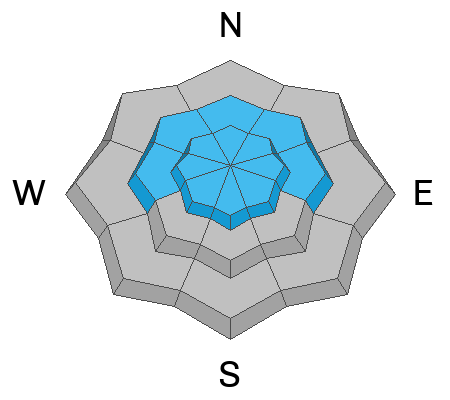
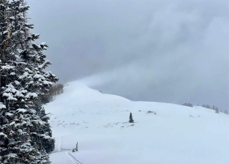
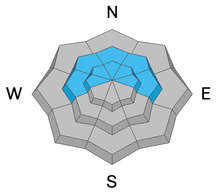
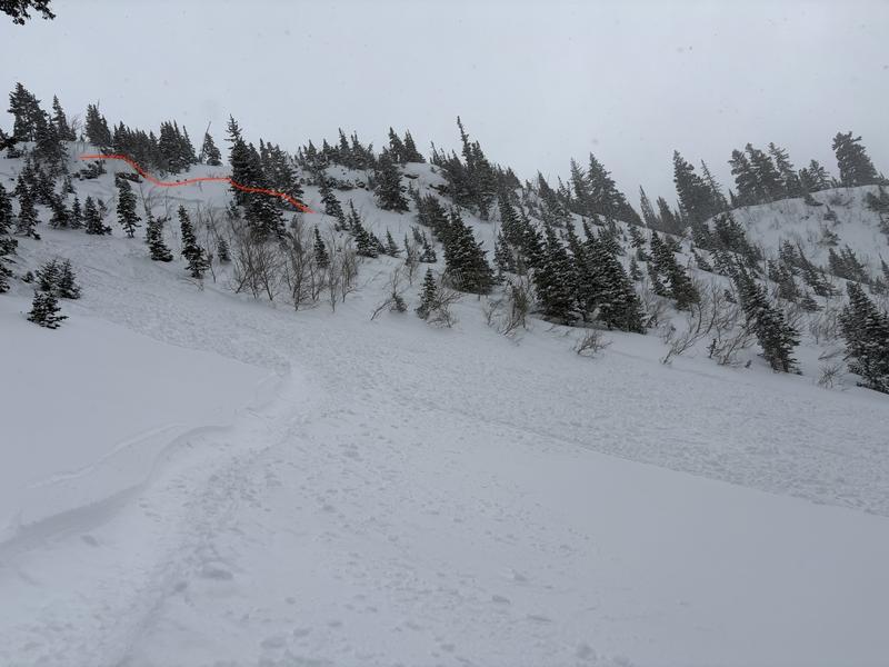
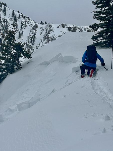
Human triggered avalanches were the rule and not the exception yesterday with regular cracking and collapsing and easy to trigger shallow soft slabs, generally failing on the old weak faceted surface snow. Many avalanches were triggered remotely (at a distance) and most prevalent in areas seeing wind transported snow on north to east facing slopes in the upper elevation bands. In isolated areas, wind was not necessarily a factor as a party triggered a shallow soft slab near the Spire in mid-White Pine (LCC) on a northeast facing slope at 8900'. (1st photo). Paige and I found very sensitive conditions above Twin Lakes Pass and we were easily able to remotely trigger a couple soft slabs from 100' away. (2nd photo). We did hear rumors of two skiers caught and carried in mid-LCC, but don't have any details.

You can view all recent observations here.

Avalanche Problem #1
Wind Drifted Snow
Type
Location
Likelihood
Size
Description

Brett Pelletier photo of significant wind loading along the Park City ridgeline, blowing from the southwest, loading the northeast aspect....observation HERE

I suspect conditions will be slightly less sensitive today, but you will still be able to trigger shallow soft slabs 8-18" thick and up to 150' wide in recently wind loaded terrain. Again, these will be most prevalent on north through east facing slopes in the upper elevations, but isolated pockets exist around the compass and in lee terrain in the mid-elevations. Some of these soft slabs may be triggered at a distance...as the new slabs sit uneasily on very weak faceted snow and in some cases, surface hoar. Cracking and collapsing are clear indicators of localized instability. These wind drifted snow and new snow avalanches (below) will soon transition to the PWL (persistent weak layer) category in the coming days.

Avalanche Problem #2
New Snow
Type
Location
Likelihood
Size
Description

While wind loading is the predominant slab builder, it should be noted that the yesterday's snow was thick and dense and just cohesive enough to avalanche on its own. Note the report of the skier triggered slide near the Spire (Weuling photo (observation) in recent activity) and pockets of soft slab along the Silver Fork Headwall. (below). Again, these soft slabs will be most prevalent on west to north to east facing slopes as they are bonding poorly to the old snow surfaces. Any slide may gouge into weak sugary facets, leaving larger debris piles.

Additional Information
General Announcements

This information does not apply to developed ski areas or highways where avalanche control is normally done. This forecast is from the U.S.D.A. Forest Service, which is solely responsible for its content. This forecast describes general avalanche conditions and local variations always occur.