Join us at our 2nd Annual Blizzard Ball

Forecast for the Salt Lake Area Mountains

Trent Meisenheimer
Issued by Trent Meisenheimer on
Saturday morning, February 1, 2020
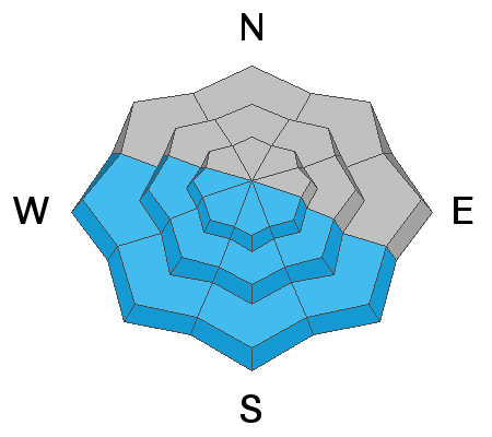
The avalanche danger is MODERATE on all steep slopes facing southeast, south, southwest and west for wet snow avalanches. Natural and human triggered slides will be possible.
There is a LOW avalanche danger on slopes facing northwest, north, northeast and east. In this terrain, wind drifted snow will be the biggest concern and we need to watch for unstable snow on isolated terrain features. Small avalanches in extreme terrain can have significantly higher consequences.
Low
Moderate
Considerable
High
Extreme
Learn how to read the forecast here
Special Announcements
Discounted lift tickets - Thanks to the generous support of our Utah ski resorts and Ski Utah, all proceeds from these ticket sales go towards paying for avalanche forecasting and education! Get your tickets here.
Weather and Snow
Under clear skies, the mountain temperatures begin to climb. Currently, the 700 millibar (11,000') temperature is 34°F. However, by this afternoon it's forecasted to warm to 39°F. The forecasted temperature for the Alta Guard station at 8,800' will be 43°-47°F today. We will have plenty of sunshine to go with the warm temperatures as only some thin high clouds pass overhead at times. Winds remain from the NW blowing at speeds of 25-30 mph at 11,000'. Lower in elevation the winds are generally 10-15 mph on the exposed ridgelines.
The northerly wind from the past few days has taken its toll on the snow surface, especially in the alpine terrain. Some southerly slopes were kissed by the sun yesterday and will have a crust. In sun and wind sheltered terrain, dense, soft, settled powder, can still be found. We do have a strong cold front on tap for late Sunday evening. This will be a welcomed storm as it will drop temperatures and bring mountain snow.
Fun fact - I just got off the phone with Dave Richards aka "Grom" Director of Alta's Avalanche Office, where he let me know that Alta Ski Area just recorded the fourth largest January for snowfall since 1980 with 152.5" of snow.

Our Week in Review - where will highlight significant snow and weather from this past week - is available HERE.
Recent Avalanches
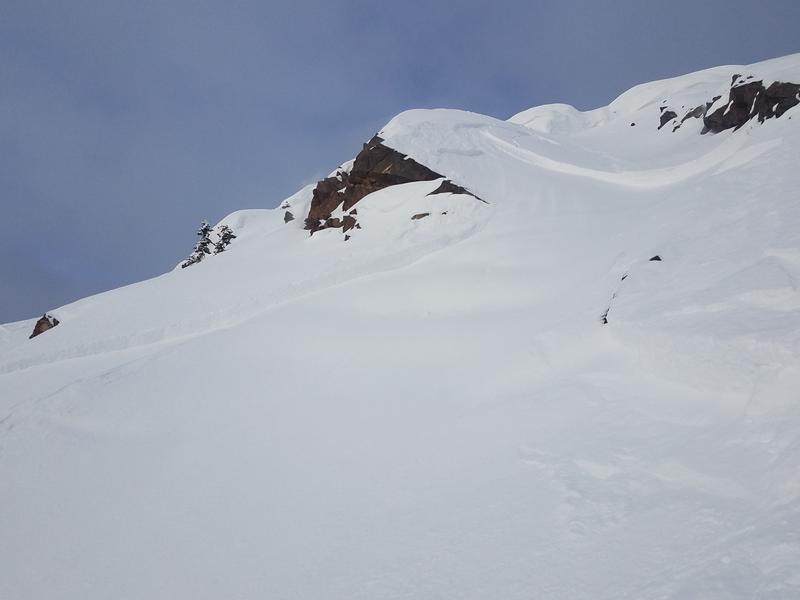
Yesterday, we had two reports of human triggered avalanches. One was on the southeast face of Mount Superior at 10,900' where a skier triggered a wind slab that was 12" deep and 80' feet wide, running 800' vertical feet downhill. The rider was not caught or carried. The other avalanche was triggered by a slope cut on a steep slope on Rainbow Peak in between White/Red Pine and was 18" deep 35' feet wide and ran a few hundred feet downhill. Both of these reports can be found in our current observations HERE.
Photo: Skier triggered wind slab on Mount Superior
Ad
Avalanche Problem #1
Wet Snow
Type
Location
Likelihood
Size
Description
Rapidly rising temperatures along with plenty of direct sunshine will create unstable snow on steep slopes that face southeast through west today. This morning the avalanche danger is LOW but will quickly rise to MODERATE as the sun heats the snowpack. Keep an eye out for rollerballs, pinwheels and small loose wet avalanches as this is a clue that the snow is becoming unstable and wet. If you're seeing these signs it's time to head for a northerly facing slope where the snowpack remains cold and dry. These will be wet loose avalanches
Danger Trend: Increasing
General Announcements
This information does not apply to developed ski areas or highways where avalanche control is normally done. This forecast is from the U.S.D.A. Forest Service, which is solely responsible for its content. This forecast describes general avalanche conditions and local variations always occur.