Join us at our 2nd Annual Blizzard Ball

Forecast for the Salt Lake Area Mountains

Trent Meisenheimer
Issued by Trent Meisenheimer on
Sunday morning, February 2, 2020
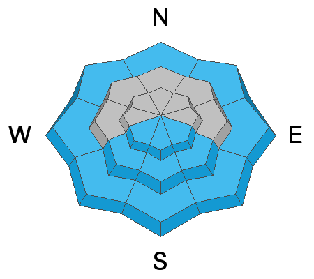
The avalanche danger is MODERATE on all steep slopes at the mid and upper elevations for Wind Drifted Snow avalanches. Human triggered avalanches are possible.
On slopes facing southeast through southwest as well as all lower elevations we have a LOW danger for Wet Loose Snow avalanches.

At the low elevation terrain we have a LOW danger.
Low
Moderate
Considerable
High
Extreme
Learn how to read the forecast here
Special Announcements
Discounted lift tickets - Thanks to the generous support of our Utah ski resorts and Ski Utah, all proceeds from these ticket sales go towards paying for avalanche forecasting and education! Get your tickets here.
Forecaster Trent Meisenheimer will be giving a talk on the "State of The Wasatch Snowpack" at the Black Diamond Retail Store in Millcreek - Feburary 13th, from 7:00-8:30 pm. See you there!
Weather and Snow
Under partly clouds skies the westerly winds are wreaking havoc with speeds of 40-50 mph gusting 82 mph at 11,000'. Even the mid and upper elevation (9,000'-10,000') anemometers are spinning 20-30 mph gusting 40 mph. Mountain temperatures remained above freezing overnight with upper elevations currently sitting in the upper 30's °F. One station at 10,500' is reporting a temperature of 39°F.
We have a strong cold front that currently sits off the coast of Oregon and should be arriving tonight around 10:00 pm. For today, winds will continue blowing from the southwest with speeds of 20-30 mph at 9,000' and 30-40 mph at 11,000' with strong gusts at times. These winds will usher in thickening clouds and will keep the temperatures warm. Once the trough axis passes overhead tonight the winds will veer to the northwest, temperatures will plummet, and we could see 8-16" of new snow by Monday afternoon. It's a welcomed return to winter.

Our Week in Review - where will highlight significant snow and weather from this past week - is available HERE.
Recent Avalanches
Yesterday, we had two human triggered avalanches in the backcountry.
1. Westerly facing slope at 10,000' in elevation in upper Mill B South (left photo below). This slab avalanche was triggered by a skier traversing high along the cliffs and was 2-3' feet deep, 200' feet wide and ran 400' vertical feet to the flats. It's likely to have failed on a crust and facet interface much like the avalanche from the same location just down the ridge in Mill B South on January 19th.
2. Snowboarder triggered wind drifted snow avalanche on a southeast facing slope at 10,200' off of Pioneer Ridge. This avalanche was 12" inches deep, 75' feet wide, running 350' vertical feet. The snowboarder was able to self arrest on the bed surface and was not caught or carried. (right photo below, courtesy of Brighton Ski Patrol)
Finally, the warm temperatures and direct sunlight yesterday created a small natural wet loose avalanche cycle on southerly aspects.
Ad
Avalanche Problem #1
Wind Drifted Snow
Type
Location
Likelihood
Size
Description
Westerly winds are currently blowing across the Wasatch Range creating new slabs of wind blown snow. Even though there is not a lot of snow to blow around the wind speeds are so strong that it will grab and strip away anything it can and deposit it on the lee side of ridges and terrain features. I would expect hard and soft slabs of snow scattered around the range in a very random order. Some dirfts will be soft and fresh and others will be compressed into shallow hard slabs of wind drifted snow.
There are two things I would be looking for today:
1. Any snow that is stiff and hard under my skis, board, or sled. This type of hard wind slab usually sounds hollow (like a drum) looks wind rippled and pressed into the terrain.
2. Fresh or old soft drifts of wind blown snow. These will feel dense, thick or cakey. They will look rounded and pillowy. Any cracking is a sign of instability.
Unfortunately, the winds are so strong that the location of these soft and hard slabs of wind blown snow will NOT only be limited to the ridgelines. They could also be found in cross-loaded open terrain, mid-slope breakovers, or any other terrain feature that has channeled the wind.
Avalanche Problem #2
Wet Snow
Type
Location
Likelihood
Size
Description
It's hard to ignore the above freezing temperatures across the range. However, with limited direct sunlight and the strong winds I would assume the wet snow problem will be kept at bay today. As you move through terrain look for and avoid steep slopes where the snow is wet, saturated and heavy. This problem is for wet loose snow. You can find the definition HERE. If the snow is frozen, there is no problem.
Danger Trend: Decreasing
General Announcements
This information does not apply to developed ski areas or highways where avalanche control is normally done. This forecast is from the U.S.D.A. Forest Service, which is solely responsible for its content. This forecast describes general avalanche conditions and local variations always occur.