Forecast for the Salt Lake Area Mountains

Drew Hardesty
Issued by Drew Hardesty for
Tuesday, December 31, 2019
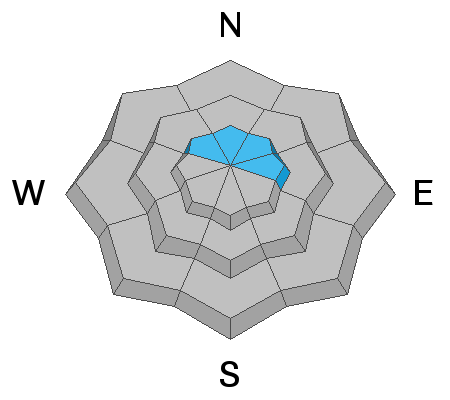
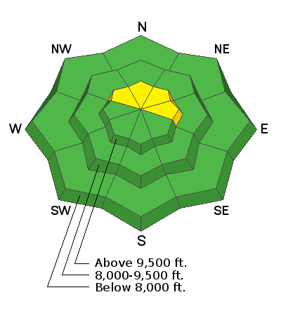
Most terrain has an overall LOW avalanche danger. Sluffing in the low density snow is a concern in the steepest terrain. Human triggered avalanches 3-5' deep are unlikely at this point and isolated to steep, thin, rocky terrain on northwest to east facing slopes. Remember that risk is inherent in mountain travel.

Heads Up: Tomorrow's storm will be a game changer. The avalanche danger may reach HIGH in the coming days.
Low
Moderate
Considerable
High
Extreme
Learn how to read the forecast here
Special Announcements
Get discount lift tickets HERE. Thanks for this generous support from Utah Ski Resorts and Ski Utah. All proceeds go directly to supporting the UAC.

Landmines - Notes from an Army officer frequently deployed to the middle east who is also a skier living in Utah.

Podcasts - Check out two recent ones with Doug Workman and Jenna Malone.

Weather and Snow
It's about as good as it gets: 5 star powder, light wind, good stability. A good way to kiss 2019 goodbye. 2020 is gonna roar in like a lion. More below.
Head to the high country: Low-level stratus has the low/mid elevations thick with clouds but we have blue skies above the cloud deck. Similarly, temps are inverted: they're in the teens up high but at or below zero at the trailheads and mountain basins. Winds are light from the northwest.

A strong and potent winter storm arrives tonight through Thursday that'll bring 1-2' of snow, strong northwest winds and significantly elevate the avalanche danger. Time to recalibrate the mindset.
Recent Avalanches
Only sluffing in the cold smoke reported yesterday.
Ad
Avalanche Problem #1
New Snow
Type
Location
Likelihood
Size
Description
Sluffing in the low density snow is the primary concern today and is most problematic in the steepest, sustained terrain. Some are gathering a bit of mass and running over 500' vertical.
I make mention of this concern because many of us are stepping into more aggressive terrain and these sluffs - without proper attention or terrain management - do have the ability to trip up skiers and riders, push them into trees or over cliff bands or bury them deeply in terrain traps. Make no mistake - the snow will continue to move with provocation on slopes approaching 40° and steeper. The good news is that they are very predictable and responsive to ski cuts but those of you ticking off The Chuting Gallery well know that in some of that terrain, there's nowhere to run, nowhere to hide. (pc: Mark White)
Avalanche Problem #2
Persistent Weak Layer
Type
Location
Likelihood
Size
Description
We sound like a broken record (does anyone even remember what a vinyl record is?) with this persistent weak layer which has a hard slab 3-5 feet thick resting on top of it. This layer is mostly dormant and has generally been gaining strength, but it is not forgotten. We have been keeping an eye on it because it could come definitely to life (video) in the future and produce avalanches if it is stressed by a heavy load of new snow. This layer exists above 9000 feet but is more widespread above 9500 feet on NW though E aspects. This storm will be a good test.
How will this layer react to the coming storm? Good question. With enough snow and wind, it's possible that new avalanches may step down into the old persistent weak layers and most likely on repeater avalanche paths and in steep thin rocky terrain, particularly on the periphery of the Cottonwoods and perhaps in Provo.
General Announcements
This information does not apply to developed ski areas or highways where avalanche control is normally done. This forecast is from the U.S.D.A. Forest Service, which is solely responsible for its content. This forecast describes general avalanche conditions and local variations always occur.