

Forecast for the Salt Lake Area Mountains

Issued by Nikki Champion on
Wednesday morning, January 1, 2020
Wednesday morning, January 1, 2020
The avalanche danger is on the RISE today.
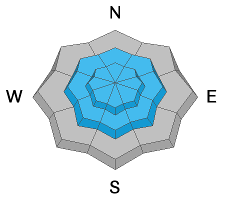
Today is simple: heavy snowfall and high winds will create avalanches. The avalanche danger is CONSIDERABLE on all mid and upper elevation aspects and MODERATE on all lower elevation aspects.
Today is simple: heavy snowfall and high winds will create avalanches. The avalanche danger is CONSIDERABLE on all mid and upper elevation aspects and MODERATE on all lower elevation aspects.
Both human-triggered and natural avalanches are likely especially as the snowfall intensifies. Avoid being on or underneath slopes steeper than 30 degrees, and avoid avalanche runout zones.
The avalanche danger may reach HIGH by the afternoon with the rapidly changing conditions.. Evaluate snow and terrain carefully. Use caution while route finding, and make conservative decisions.

Low
Moderate
Considerable
High
Extreme
Learn how to read the forecast here
 Special Announcements
Get discount lift tickets HERE. Thanks for this generous support from Utah Ski Resorts and Ski Utah. All proceeds go directly to supporting the UAC.
 Weather and Snow
This morning, mountain temperatures are in the mid-20s F at trailheads and low 20s F at ridgetops. Winds are westerly and light in the valley, but increasing rapidly at ridgetops with gusts up to 60 mph. Light snowfall began around 5:00 AM with trace to 2 inches of snow so far.
Today, the bottom line is that it's going to snow and it's going to blow. Initially, the snow will fall with warmer temperatures and high densities, bringing about 6-10 inches of 8-10% snow to the Wasatch by the early afternoon. Then temperatures will begin to drop and we will transition to a cooler northwest flow, bringing another 7-12 inches of lower density snow. On top of the increased snow amounts, winds will continue to be strong and westerly averaging 20-35 mph with gusts up to 75 mph at ridgetops.

The Alta Guard recorded 61" of snow for December with winter totals so far (Nov/Dec) at 149". Average is 162". Based on how the skiing and riding has been, it sure doesn't feel below average out there.
 Recent Avalanches
Sluffs of low-density snow still reported to be running long and fast.
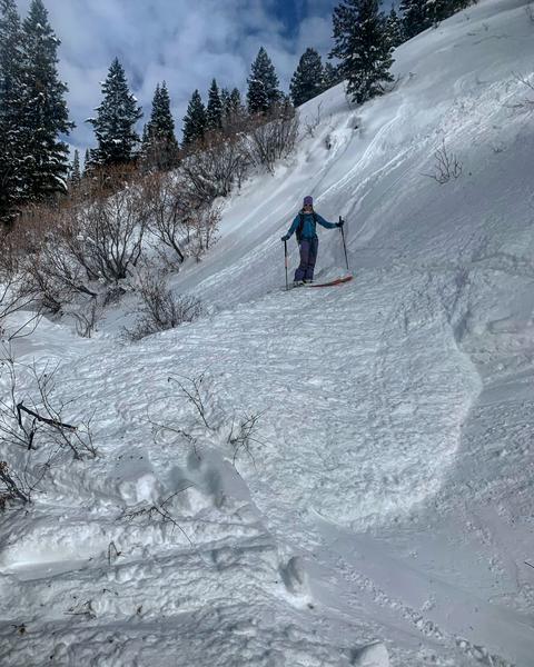
Yesterday a skier triggered a large sluff in Scary Gulley of East Butler Fork on a steep west-facing slope, putting 6 feet of snow on the skin track. On West Desolation Ridge, a sluff ran up to 100 feet wide and 300 feet long. Off the American Fork East Twin dry loose avalanches were seen on SW-SE facing slopes, up to 50 feet wide and running up to 700 feet.
Photo of 6 ft of debris crossing the skin track in east Butler Fork after a large sluff. (Photo: M. White)
Check out all of our observations HERE.

Avalanche Problem #1
New Snow
Type
Location

Likelihood
Size
Description
Before the coming storm, we had beautiful low-density cold smoke. The sluffs that were running long and fast indicated weak snow and a variety of smooth bed surfaces exist. Add new snow and wind and we have a pretty straight forward problem on our hands, particularly with a higher density new storm slab on top of that weaker layer of snow. Heavy snowfall will create sensitive storm snow today, and these may even be triggered at a distance.
Human triggered avalanches are likely, as well as natural avalanches, especially during any period of high precipitation intensity and increased winds. Pay attention to rapidly changing conditions, and watch for and avoid slopes with cracking, avalanching, even on smaller slopes.
Avalanche danger will be on the RISE today.
Avalanche Problem #2
Wind Drifted Snow
Type
Location
Likelihood
Size
Description
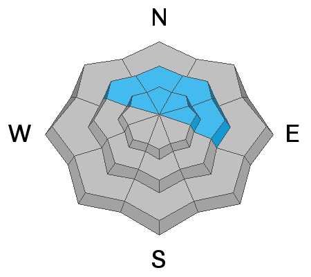
Today's strong west to northwesterly winds, which could be gusting up at 75 mph at ridgetops, will have plenty of new snow to work with, creating fresh wind drifts on all aspects at the mid and upper elevations. These wind drifts will be most pronounced near ridgelines and on easterly and southerly facing terrain where the new snow will be deposited.
Additional wind loading will just increase our problem of a strong slab, over weak snow. The snowpack becomes a game of Jenga in which we have removed the bottom pieces, and just keep adding more to the top. Too much load on top of the weak base and it will topple over.
Look for signs of wind drifted snow, such as soft pillows, cracking, and whumphing and avoid them.
Watch for sensitive cornices along upper elevation ridgelines, give cornices a wide berth as they can break back farther than expected.
Avalanche Problem #3
Persistent Weak Layer
Type
Location
Likelihood
Size
Description
We haven’t seen any activity on this layer for over 10 days now. This layer has been mostly dormant and has been gaining strength, but it is not forgotten. This storm system will be a good test of this layer.
With enough snow and wind, it is possible that new avalanches may step down into the old persistent weak layer. An avalanche in the persistent weak layer is most likely on repeater avalanche paths, generally shallower snowpacks and in steep thin rocky terrain.
Hopefully, this storm will be the telltale that lets us put this layer to rest for a while.
General Announcements
This information does not apply to developed ski areas or highways where avalanche control is normally done. This forecast is from the U.S.D.A. Forest Service, which is solely responsible for its content. This forecast describes general avalanche conditions and local variations always occur.