Sign Up for the Utah Snow and Avalanche Workshop (USAW) on December 7th!

Forecast for the Salt Lake Area Mountains

Nikki Champion
Issued by Nikki Champion on
Thursday morning, December 19, 2019
Today a MODERATE avalanche danger exists on mid and upper elevation slopes. While the snowpack is slowly showing signs of increasing stability triggering an avalanche 2-5 feet deep in the persistent weak layer remains possible, especially on steep NW, N, NE and East facing terrain. Evaluate snow and terrain carefully and watch for slabs of wind drifted snow.
LOW avalanche danger is found on all slopes under 8,000' in elevation.
Low
Moderate
Considerable
High
Extreme
Learn how to read the forecast here
Special Announcements
Final report for the Dutch Draw avalanche fatality is available HERE.
Consider donating to the Matt Tauszik Memorial Fund to help his wife and young son.

Spruces Parking Lot in Big Cottonwood Canyon - UPD and UDOT will be closing this parking lot at 1:30 a.m. during storms to facilitate plowing in the morning. The closure will last until at least 4:30 a.m. or possibly longer. Overall this should mean more parking spaces. Follow @udotcottonwoods to know when these closures will occur.

Weather and Snow
This morning temperatures are in the mid teens F at trailheads and low teens F at ridgetops. Winds are south and westerly currently blowing in the single digits to low teens mph.
Yesterday winds shifted from north to southwesterly, averaging in the teens to low 20s mph, and gusting up to 40 mph at ridgelines.
Today, temperatures should remain in the mid teens F to the mid 20s F. Skies will become sunny this afternoon as a ridge of high pressure builds over the area. Winds will shift from south and westerly to northwest, and could gust up to 30 mph at ridgelines near 11,000 ft.
Over the last few days, the snow got damp on some south-facing slopes and even produced rollerballs and a few small loose wet sluffs. On south-facing aspects expect a solar crust in the morning and a damp surface in the afternoon.
Recent Avalanches
Ski resorts continue to use explosives to test high north facing terrain. Yesterday, there were only reports of shallow explosive triggered avalanches in the surface snow. No avalanches reported in the old facets near the ground.

No new avalanches were reported in the backcountry yesterday.

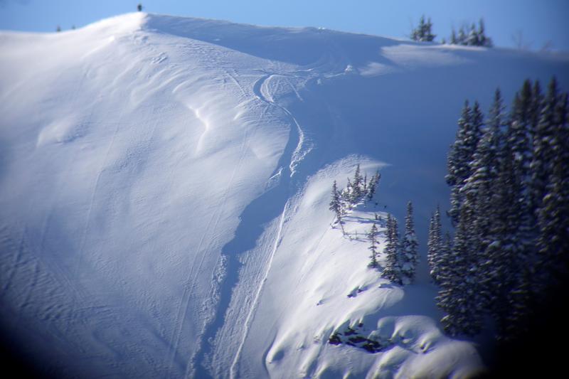
A skier with a speed wing (like a paragliding wing) triggered a small avalanche near the scene of Sunday's fatal avalanche in Dutch Draw, but he flew above it and was not caught. However, the Park City Ski Patrol began organizing a response because there was a set of ski tracks entering the avalanche and none exiting. Thankfully the skier notified a ski patroller that he was ok. (photo - Park City Ski Patrol).
All other avalanches and observations are listed HERE.
Ad
Avalanche Problem #1
Persistent Weak Layer
Type
Location
Likelihood
Size
Description
Time is our friend in this situation. With each passing day, the odds of triggering an avalanche decrease a little, but it still remains possible to trigger a deadly 2-5 ft deep slab on a persistent weak layer near the ground on NW, N, NE and E facing slopes.
Avalanche activity on this layer has been tapering off, and results in snowpit tests are steadily improving. These signs show that triggering an avalanche is getting harder to do, but it is not an overnight fix. Just because the likelihood has decreased doesn't mean the problem no longer exists. Steep, upper elevation aspects, especially those that have already slid leaving a shallower snowpack are especially suspect and could be easier to trigger. While we can't quantify the chances of triggering avalanches on this persistent weak layer, we do know it remains possible. What we can do is avoid slopes where this problem exists.
Yesterday winds shifted directions to the southwest, and gusted up to 40 mph at ridgelines. This additional loading on northeast facing slopes will increase the chances of triggering a large avalanche. Look for signs of wind drifted snow on Northeast aspects and avoid them.
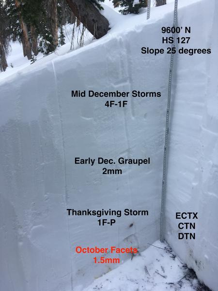
A photo from the Snowbird periphery shows the standard snowpack structure across the range. (PC: Zimmerman-Wall/Bremer/Latosuo AIARE PRO 1)
Avalanche Problem #2
Wind Drifted Snow
Type
Location
Likelihood
Size
Description
Winds since the weekend have blown from the north, west and southwest with gusts near 40 mph. Moving into today they should shift again to the northwest and could gust up to 30 mph at ridge lines. With a variety of wind directions, speeds and lingering new snow from the weekend soft slabs of wind drifted snow could exist on all aspects above 8000 feet.
Today, simply LOOK for signs of wind deposited snow. The good news is that these slabs can be identified visually and can be easily avoided.
Additional Information
General Announcements
This information does not apply to developed ski areas or highways where avalanche control is normally done. This forecast is from the U.S.D.A. Forest Service, which is solely responsible for its content. This forecast describes general avalanche conditions and local variations always occur.