
Mark Staples
2015-2024 - Director, Forest Service Utah Avalanche Center
NOTE: This blog post was written in December 2019 when there was similar weak snow at the ground to December 2020 except when this blog was written, there was a slab of snow on all slopes. This slab was an avalanche problem where the weak snow existed underneath it. As of December 5, 2020, most mountain areas in Utah have weak snow at the ground but no slab on top of it to produce an avalanche.
In many areas of Utah, the main avalanche problem that is causing large deadly avalanches is a slab of snow resting on a persistent weak layer of faceted snow. That's a mouthful. What does it mean?
The Persistent weak layer can be defined 3 ways:
1. A layer at the ground on which avalanches will fracture, and
2. Old snow from October and early November that became weak, sugary, and faceted, and
3. Faceted snow crystals (or just facets).
Why is it such a deadly problem?
This layer exists at the ground and has a slab of snow 2-4 feet thick on top of it. Avalanches will break 2-4 feet deep over entire slopes or entire bowls instantly
There are two strategies to avoid this avalanche problem
(1) Ride slopes less than 30 degrees in steepness. These slopes aren't steep enough to slide. Also, avoid being underneath these steep slopes so that you don't trigger an avalanche and have it crash down on top of you.
OR
(2) Ride slopes where this problem doesn't exist. That's easy if you know where the problem exists. It exists on slopes that face Northwest, North, Northeast, and East. Read more to learn why it is on these slopes.
Why does this persistent weak layer exist on some slopes but not others?
The key to understanding where this problem exists and why it formed is to know something about which slopes had snow on them this fall prior to the week of Thanksgiving. Many south-facing and west-facing slopes received some snow but it melted under the warm fall sunshine. North-facing and east-facing slopes at mid and upper elevations kept this early snow. The early snow changed from little snowflakes and rounded ice grains to faceted snow crystals this fall. This faceting process occurs because the ground is always 32 degrees F when covered by snow. Water vapor moves upward through the shallow early season snowpack and changes snow crystals into faceted crystals with sharp edges. These faceted crystals form a weak layer because they do not bond to each other.
The video below shows how faceting happens. (When these faceted crystals continue to grow and get weaker, they become depth hoar crystals).
Trent explains more about this process from a recent field day in the video below
KNOWING where this avalanche problem exists is a matter of life and death.
You need to know which slopes held old snow this fall. We can use a combination of aerial photographs, satellite imagery, a compass, and our shovel. These are all tools to help us figure out where this problem exists. They are tools not answers. We have to be detectives and hunt for this layer so that we can avoid slopes that have it.
(1) COMPASS
Using a compass helps us know which direction a slope faces. The sun can help know which direction a slope faces. South-facing slopes are sunny and north-facing slopes are shady. This layer exists on mid and upper elevation slopes (above 8000 feet in the Central Wasatch) on Northwest, North, Northeast, and East facing slopes.
(2) SHOVEL
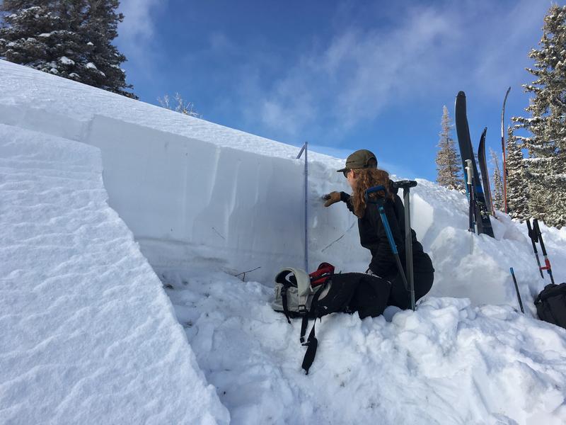
The most definitive way to check for the existence of this weak layer is to use your shovel to dig to the ground and see if this layer exists. This is BY FAR the most definitive way to look for this avalanche problem. Taking an avalanche class can help you learn to identify this persistent weak layer of faceted snow. In many cases, this layer is an obvious layer of loose, sugary snow.
Do you need to dig on the slope you hope to ride? NO! (1) dig on a nearby low angle slope that has the same aspect and elevation (2) dig away from trees (3) dig in a spot with a clear view of the sky, and (4) dig a little below ridgelines so that you're not digging in a wind pillow. The photo below clearly shows weak snow at the ground. This weak faceted snow feels like sugar when you scoop a handful.
Stability tests can also identify these weak layers in the snowpack.
Early season satellite and aerial imagery is a great way to find out where the early season snow existed prior to snowfall that blankets the mountains and hides this deadly weak layer of old snow. These products are a great tool, but that is all. They are a tool for us to do our homework. They are not a replacement for field work.
Be careful when you take tools like these and apply them on smaller scales. A skier died in an avalanche in Colorado on Jan 5, 2019. They had estimated slope angles with a mapping tool the night before but never measured them in the field. Small errors like this can be deadly. Read the full accident report HERE.
(3) AERIAL PHOTOGRAPHS-
Aerial images were captured on November 20th 2019 by Steven Loyd & @mattgalland. A huge thanks to these guys for taking the time to fly over the mountains and capture these images. We put these photos together into the video below. If you recognize terrain where you like to ride, STOP the video and LOOK for slopes with snow and slopes without. The slopes covered in snow are ones that have a persistent weak layer at the ground.
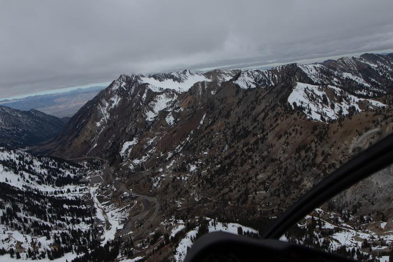
Below is a photograph looking down Little Cottonwood Canyon towards the west. North facing slopes have snow and face to the right. South facing slopes do not have snow and face to the left.
(4) SATELLITE IMAGERY-
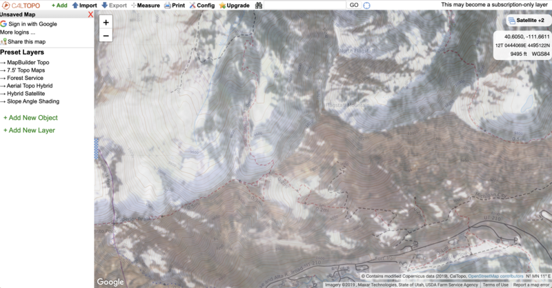
Modern mapping tools can display satellite imagery at different dates and show which slopes held snow and which didn't this fall. A great discussion on using Cal Topo can be found on the Wild Snow website HERE. These satellite images help you get an idea where there is and isn't snow, but it's not precise enough for accurate mapping.
Below is an image from CalTopo of Little Cottonwood Canyon with satellite imagery from November 19, 2019.
If you go to CalTopo, it will default to the most recent satellite imagery, and you'll have to manually select older images from this fall. See the second image below for instructions on how to select satellite photographs from different dates.

That was a great summary of the problem
Daniel cottam (not verified)
Sat, 12/14/2019


