Forecast for the Salt Lake Area Mountains

Trent Meisenheimer
Issued by Trent Meisenheimer for
Tuesday, December 17, 2019
CONSIDERABLE DANGER exists on mid and upper elevation slopes that face northwest through east for triggering a deep and dangerous avalanche on a Persistent Weak Layer of snow found at the base of the snowpack.
MODERATE danger exists on all mid and upper elevation steep terrain for triggering new snow avalanches as well as wind drifted snow avalanches.
LOW avalanche danger is found on all slopes under 8,000' in elevation.
Low
Moderate
Considerable
High
Extreme
Learn how to read the forecast here
Special Announcements
We are very sad to report an avalanche fatality that happened December 15th along the Park City ridgeline in the Dutch Draw area. The avalanche was 1 to 3 feet deep, 120' feet wide and ran 600' vertical feet to the bottom. A 45 year old male snowboarder left the Canyons Village of Park City via the backcountry exit gate at the top of the 9990' lift to access Dutch Draw. Part of the way down the slope (Conehead area of Dutch Draw), he triggered and was caught, carried and killed in an avalanche. UAC staff visited the site yesterday and will be compiling an accident report that should be done later this afternoon.
A link to the preliminary accident report can be found HERE.
Weather and Snow
Under clear skies this morning the overnight temperatures plummeted below 0°F. This morning they are slowing working there way back into the single digits °F at the upper elevations. Lower elevation trails are still reading temperatures around -5°F. It's cold. Northwest winds overnight and into this morning averaged speeds of 10-15 mph with gusts into the low 20's across the upper elevation ridgelines. Below ridgeline the winds are calm. It will be a beautiful day in the mountains with afternoon temperatures climbing into the mid 20's °F and plenty of sunshine.
Riding and turning conditions remain all time with five star powder on all aspects and elevations.
Recent Avalanches
Control work in the upper Cottonwoods reported new snow soft slabs and wind slab avalanches that were 8-24" deep and well connected. These avalanches were found on northeast facing slopes at 10,000' in elevation. Backcountry observers continue to report and find natural avalanche activity from the past weekends loading event. Check out all the observations HERE.
Ad
Avalanche Problem #1
Persistent Weak Layer
Type
Location
Likelihood
Size
Description
Large and deadly avalanches 3-5' deep may still be triggered on steep northwest, north, northeast, and east facing slopes at the mid and upper elevations. Collapsing and cracking may or may not be evident but now that the structure exists - terrain that faces the north half of the compass that is greater than 30° in steepness should be avoided for now.
The image below on the right side represents a heat map of all the reported avalanche activity since November 20th through December 17th. Notice that it's confined to mid and upper elevation north through south-easterly facing terrain. With the bullseye being north and northeast aspects.
Photo: Left side - snow structure on a northerly facing slope at 9,000' in elevation in Mineral Fork. Right side - Heat map of recorded avalanche activity.
Click on the button below for more details on how this layer formed and where you can find it.
Avalanche Problem #2
New Snow
Type
Location
Likelihood
Size
Description
Wind slab and storm snow avalanches 12-18" deep may still be triggered on steep slopes on many aspects at the mid and upper elevations. The drifts will be more prominent in (but not exclusive to) terrain with an easterly component. Test slopes, cornice drops, and ski cuts are generally effective with these types of soft slab avalanches. Look for and avoid pillowy rounded snow.
Additional Information
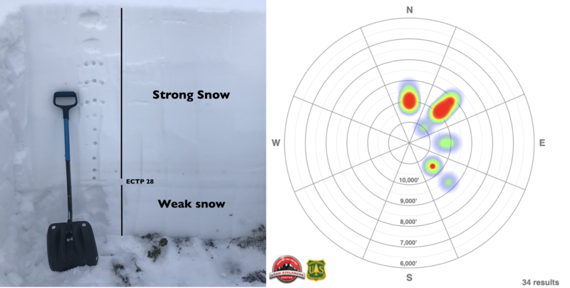
Persistent Weak Layer discussion: Yesterday, while investigating the recent avalanche accident along the Park City ridgeline we traveled along the ridge to the top of the slope. Standing there, we looked at the last six turns a 45 year old snowboarder made and stood in silence.
After a couple of minutes four avalanche professionals debated if we should descend the slope to take a look at the avalanche and investigate the crown and layering of the slide. With some discussion we all determined the upper 1/4 was low enough angle (30°) to safely descend. However, the slope midway down pitched to 33° degrees in steepness and we all felt very uncomfortable with the danger of triggering a slide there. Collectively, we decided it was too unsafe to descend the slope to look at the avalanche. We walked back to the resort safely along the ridgeline and descended a southerly aspect to the flats below. Now in the run-out zone we also determined it was too risky to enter from below because of the overhead hanging snow and the possibility of triggering another avalanche remotely (from a distance).
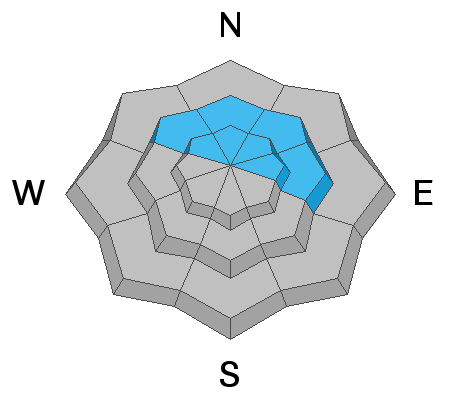
Now is the time to exercise patience in the mountains and let these weak layers gain strength and heal. I get it - the snow looks amazing on steep northerly facing aspects, the desire to ride these lines is pulling me in. However, I am just fine looking at it and saying "soon enough." The risk does not equal the reward in my book.
Yes, the slab is strong and travel is now easy. Nevertheless, the weak layer is still down there and it remains weak. The likelihood of triggering an avalanche is decreasing, signs of instability like collapsing and remote triggers are becoming less and less, but the consequence of triggering an avalanche remains the same. Avalanche activity is slowing down, however, there still remains the chance of finding the sweet spot on the slope that brings millions of pounds of snow down the mountain. Remember tracks are not a sign of stability.
What will it take for me to trust this weak layer?
  • More time
  • No more avalanches failing into the weak faceted snow. (it's only been 24 hrs since the last reported human triggered slide).
  • Extended column tests recording no propagation (not just one! many need to be done).
  • Another loading event where avalanches don't fail on this weak layer.
The good news: We have a phenomenal snowpack for December 17th and we have perfect powder on so many aspects and elevations. The low angle terrain is fast and surfy. The weak snow at the ground will eventually heal with time. With some patience we will be able to safely get after the steep terrain in time to come.
General Announcements
This information does not apply to developed ski areas or highways where avalanche control is normally done. This forecast is from the U.S.D.A. Forest Service, which is solely responsible for its content. This forecast describes general avalanche conditions and local variations always occur.