Donate to the 2024 Spring Campaign to help rebuild the UAC website.

Forecast for the Salt Lake Area Mountains

Trent Meisenheimer
Issued by Trent Meisenheimer for
Monday, December 16, 2019
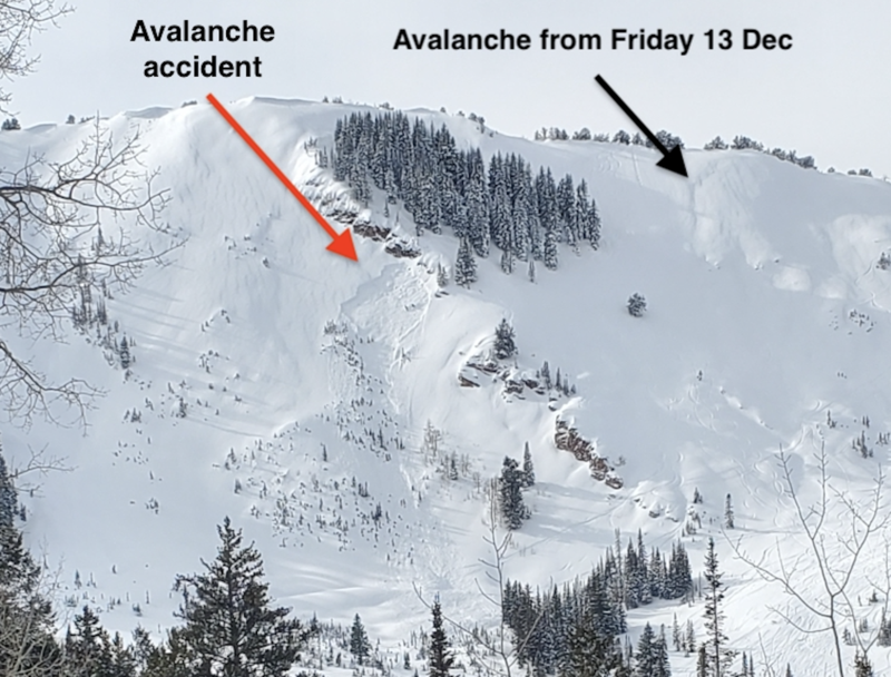
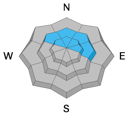
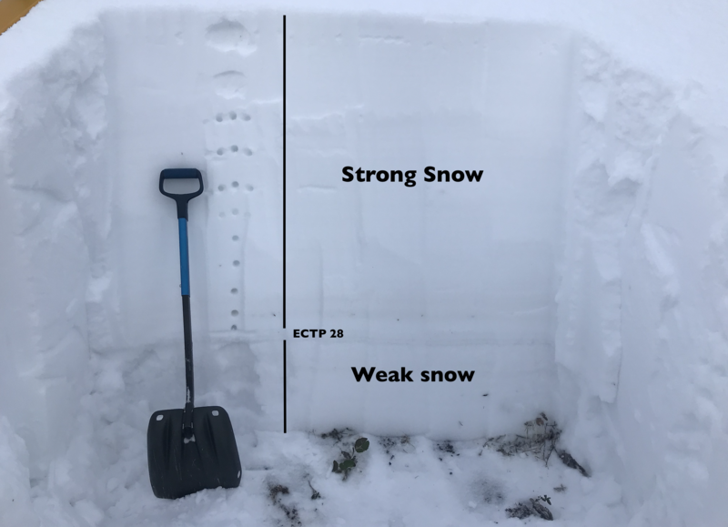
CONSIDERABLE DANGER exists on mid and upper elevation slopes that face northwest through east for triggering a deep and dangerous avalanche on a Persistent Weak Layer of snow found at the base of the snowpack.
MODERATE danger exists on all mid and upper elevation steep terrain for triggering new snow avalanches as well as wind drifted snow avalanches.
LOW avalanche danger is found on all slopes under 8,000' in elevation.
Low
Moderate
Considerable
High
Extreme
Learn how to read the forecast here
Special Announcements
We are very sad to report an avalanche fatality that happened yesterday along the Park City ridgeline in the Dutch Draw area. The avalanche was 1 to 3 feet deep, 120' feet wide and ran 600' vertical feet to the bottom. A 45 year old male snowboarder left the Canyons Village of Park City via the backcountry exit gate at the top of the 9990' lift to access Dutch Draw. Part of the way down the slope (Conehead area of Dutch Draw), he triggered and was caught, carried and killed in an avalanche.
A link to the preliminary accident report can be found HERE. UAC forecasters Mark Staples and Trent Meisenheimer will visit the site today for a complete accident report. Our deepest condolences go out to the friends, family, rescuers, and everyone affected by this tragic accident.
Weather and Snow
Under partly cloudy skies this morning the mountain temperatures are in the single digits °F at the upper elevations while lower elevation trailheads sit in the mid teens °F. Northwest winds continued to blow in the overnight hours and are currently 10-15 mph with gusts into the mid 20's at the upper elevations. Overnight, we picked up another trace to 4" of new snow. We will see the last remaining snowflakes in the early morning hours today with clearing later this afternoon as a shortwave ridge builds in for the next couple of days.
Riding and turning conditions are all time with dense, surfy snow, capped by 3-6" of Utah's famous ultra light to sweeten the deal. The weekend storm totals are below:
  • LCC - 31" (3.64"SWE)
  • BCC - 35" (3.50"SWE)
  • PC Ridgeline - 18" (2.0"SWE)
  • Ogden mountains - 20-30" (2.5-4.0"SWE)
  • Provo mountains - 18" (2.0"SWE)
Recent Avalanches
Control work in the upper Cottonwoods and along the Park City ridgeline continue to produce results with avalanches failing on weak faceted snow at the base of the snowpack. One team reported a repeater avalanche on an upper elevation north facing slope at 10,200' in elevation. This slope had previously avalanched during the Thanksgiving storm cycle and re-loaded this past weekend and avalanched again 3-4' deep 150' wide. Below is a list of all the activity reported from yesterday:
  • Accident (Dutch Draw): Human triggered - 1-3' deep by 120' wide running 600' vertical. East facing slope at 9,700' in elevation.
  • Upper Cottonwoods: Explosive triggered - 3-4' deep by 150' wide. North facing slope at 10,200' in elevation.
  • Toledo Chute: Human triggered - unknown depth by 25' wide. Caught, carried and came out on top without injuries. Southeast facing slope at 10,200' in elevation.
  • Square Top: Naturally triggered - 20" deep by 175' wide running into the flats. East facing slope at 9,800' in elevation.

Confused on locations? Check out longtime UAC boardmember Steve Achelis's Wasatch Backcountry Skiing maps (better yet get the app).
Photo: Avalanche Accident on the Park City ridgeline.
Ad
Avalanche Problem #1
Persistent Weak Layer
Type
Location
Likelihood
Size
Description
Large and bone-breaking avalanches 3-5' deep may still be triggered on steep northwest, north, northeast, and east facing slopes at the mid and upper elevations. These are unmanageable avalanches and are not to be trifled with. Collapsing and cracking may or may not be evident but now that the structure exists - This terrain should be avoided for now.
If you decide to ride steep terrain (greater than 30° degrees) on the north end of the compass, then you're gambling with your life. The photo below illustrates the size of avalanche you would be dealing with. Imagine 3-5 feet of strong dense snow (hard as hay bails) shattering all around you (like a pane of glass) with no escape. Then these massive blocks of heavy snow rocket you down the hill at 40 mph beating you to death by slamming you into tress and rocks. If you're lucky enough to survive the trauma - you better hope you're not buried - or that your partners know how to perform a rescue within 10 minutes. Does any of this sound fun? Simply stick to slopes less than 30° degrees in steepness with nothing above, below or adjacent to you.
Good news: This weak layer will heal with time and we will eventually be able to ride steep terrain in the backcountry. Just not yet. For now, surf the low angle five star powder.
Photo: Snow structure on a northerly facing slope at 9,000' in elevation. Mineral Fork.
Click on the button below for more details on how this layer formed and where you can find it.
Avalanche Problem #2
New Snow
Type
Location
Likelihood
Size
Description
Wind slab and storm snow avalanches may still be triggered on steep slopes on many aspects at the mid and upper elevations. The drifts will be more prominent in (but not exclusive to) terrain with an easterly component. Lingering storm snow avalanches may be triggered on all aspects and up to a 12-18" deep. Test slopes, cornice drops, and ski cuts are generally effective with these types of soft slab avalanches in sharp contrast to the avalanches as described above. Listen for the collapse of wind pillows. Watch for shooting cracks. These are signs that the storm and wind drifts are still reactive. Avoid the growing and still sensitive cornices along the ridgelines.
TRAVEL ADVICE: Low angle south and west facing terrain will ride just as well as any other terrain today. LOW RISK - HIGH REWARD
General Announcements
This information does not apply to developed ski areas or highways where avalanche control is normally done. This forecast is from the U.S.D.A. Forest Service, which is solely responsible for its content. This forecast describes general avalanche conditions and local variations always occur.