UDOT PLANNED AVALANCHE CLOSURES!!

Forecast for the Salt Lake Area Mountains

Drew Hardesty
Issued by Drew Hardesty for
Sunday, December 15, 2019
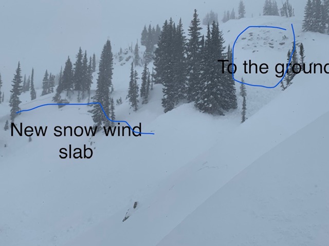
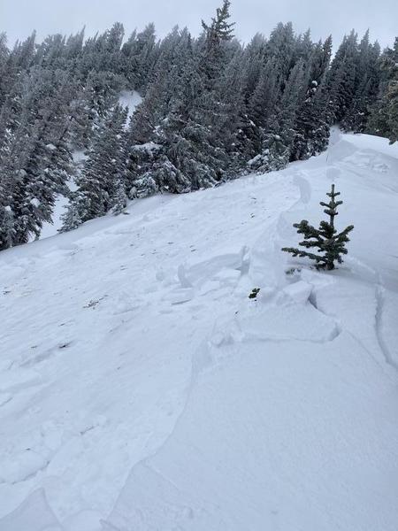
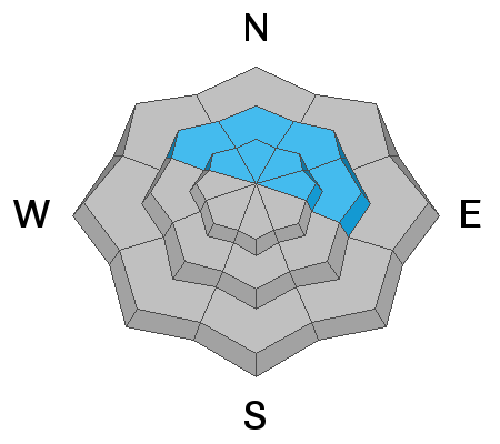
A CONSIDERABLE DANGER exists on many mid and upper elevation slopes. The danger is most pronounced on steep northwest to easterly facing terrain at the mid and upper elevations. In this terrain, human triggered slides may step down 3-4' deep and hundreds of feet wide. This terrain is to be avoided.
A Word to the Wise - Low angle south and west facing terrain: Low Risk - High Reward

If this is too much, enjoy the powder at one of our world class ski resorts.
Low
Moderate
Considerable
High
Extreme
Learn how to read the forecast here
Special Announcements
Thanks to the generous support of our Utah ski resorts and Ski Utah, we have discount lift tickets available. All proceeds support the UAC. Get your tickets HERE.

Consider taking an avalanche class, there are many different options. Click on the Education menu for a full list of classes from the UAC and other providers. Check out the Know Before You Go eLearning program for free, online, avalanche classes.

New UAC podcast: Betting Your Life (Why Forecasting is Poker and Not Chess) - A Conversation With Jenna Malone.
Weather and Snow
WOW!
Overnight we picked up another trace to an inch of new snow but only the most entitled would complain. Storm totals across the range are below. Winds now are hardly a whisper; temps are in the single digits - all what I'd call Powder Preservation Weather. We now sit at 110-150% of average for the winter (courtesy of our partners here at the NWS - the Colorado Basin River Forecast Center). 5 star mid-December snow coverage sits at 55-75" up high, and 35" down low.
LCC - 31" (3.64"SWE)
BCC - 35" (3.50"SWE)
PC Ridgeline - 18" (2.0"SWE)
Ogden mountains - 20-30" (2.5-4.0"SWE)
Provo mountains - 18" (2.0"SWE)

Our Week in Review - summarizing the significant weather and avalanche events of the past week - can be found here.
We've been working on revamping our Mountain Weather page - you can find it in the Forecast section of the Menu above.

We'll have mostly cloudy to overcast skies today with some lake-effect flurries for tonight. Temps stay in the ice-box with light northwest winds. Clearing expected for Monday eve through Wednesday eve with a warming trend and weak storm Thurs.
Recent Avalanches
Ski areas snow safety teams found widespread sensitive new snow avalanches on a variety of aspects and elevations and triggered a few larger avalanches in upper elevation northerly terrain. These avalanches in upper LCC and the south end of the PC ridgeline released on our old persistent weak layer of early season facets up to 3-5' deep and a couple hundred feet wide.
Backcountry riders also found hyper-sensitive new snow avalanches 12-18" deep on a variety of aspects and elevations. People triggered many of these at a distance where they in turn would sympathetically trigger more new snow pockets. Observer Dave Coyne's photo is below. One of these pockets stepped 2-3' deep into old weak snow near the ground above Twin Lakes Pass (northeast facing @10,100').
In upper Porter Fork near Mt Raymond on Friday, a skier triggered an avalanche on our old nemesis persistent weakness near the ground on a run called Paradise. This was on a steep northeast facing slope at 9000'. (pc Asay)

Confused on locations? Check out longtime UAC boardmember Steve Achelis's Wasatch Backcountry Skiing maps (better yet get the app).
Ad
Avalanche Problem #1
Persistent Weak Layer
Type
Location
Likelihood
Size
Description
Large and bone-breaking avalanches 3-4' deep may still be triggered on steep northwest to east facing slopes at the mid and upper elevations. These are unmanageable avalanches and are not to be trifled with. Collapsing and cracking may or may not be evident but now that the structure exists and this terrain should be avoided for now.
Short term: In the short term, this wallop of a storm is more than enough to stress and overload the old pre-existing PWL (persistent weak layer) formed in the late autumn. Your weight will additionally stress this unstable structure - and you may do so from above, adjacent, or below the steep terrain.
Long term: the deeper snowpack will help to slowly strengthen the faceted snow, the structure will trend more stable, and much deeper snow makes it more difficult to trigger and activate these basal weak layers. Soon, but not now.
Take the long view.
Click on the button below for more details on how this layer formed and where you can find it.
TRAVEL ADVICE: Stay off of and out from underneath steep northwest to east facing terrain at the mid and upper elevations.
Avalanche Problem #2
New Snow
Type
Location
Likelihood
Size
Description
Wind slab and storm snow avalanches may still be triggered on steep slopes on many aspects at the mid and upper elevations. The drifts will be more prominent in (but not exclusive to) terrain with an easterly component. Lingering storm snow avalanches may be triggered on all aspects and up to a 12-18" deep. Test slopes, cornice drops, and ski cuts are generally effective with these types of soft slab avalanches in sharp contrast to the avalanches as described above. Listen for the collapse of wind pillows. Watch for shooting cracks. These are signs that the storm and wind drifts are still reactive. Avoid the growing and still sensitive cornices along the ridgelines.
TRAVEL ADVICE: Low angle south and west facing terrain will ride just as well as any other terrain today. LOW RISK - HIGH REWARD
Additional Information
Avalanche Rescue is the real deal. You must feel completely confident that you can pull off an avalanche rescue if things go wrong today. Even this may not save the day as roughly 1/4-1/3 of all fatalities are due to traumatic injury. If there is an avalanche accident, CALL 911 and say this is a backcountry emergency. But make no mistake - YOU NEED TO PULL OFF THE RESCUE, AND MOST LIKELY YOU HAVE ONLY 15-20 MINUTES TO DO SO.
KNOW THAT RESCUE TEAMS ASSUME A GREAT DEAL OF RISK in coming in to help injured or avalanched parties. AS ALWAYS, PLEASE OBEY CLOSURES AND UPHILL POLICY RESTRICTIONS AS INDICATED BY SKI AREAS AND UDOT.
General Announcements
This information does not apply to developed ski areas or highways where avalanche control is normally done. This forecast is from the U.S.D.A. Forest Service, which is solely responsible for its content. This forecast describes general avalanche conditions and local variations always occur.