Forecast for the Salt Lake Area Mountains

Drew Hardesty
Issued by Drew Hardesty for
Saturday, December 14, 2019
The avalanche danger is HIGH. Dangerous avalanche conditions exist. Natural and human triggered storm snow avalanches are likely this morning on many aspects.
NOTE! Any new snow avalanche may step down 3-4' deep and hundreds of feet wide on steep northwest to east facing slopes.
The key to safe riding today is to simply avoid being on or underneath any slopes 30 degrees or steeper.

If this is too much, enjoy the powder at one of our world class ski resorts.
Low
Moderate
Considerable
High
Extreme
Learn how to read the forecast here
Special Announcements
Little Cottonwood Canyon is currently closed for avalanche control work with an estimated opening of 8AM.

Thanks to the generous support of our Utah ski resorts and Ski Utah, we have discount lift tickets available. All proceeds support the UAC. Get your tickets HERE.

Consider taking an avalanche class, there are many different options. Click on the Education menu for a full list of classes from the UAC and other providers. Check out the Know Before You Go eLearning program for free, online, avalanche classes.

New UAC podcast: Betting Your Life (Why Forecasting is Poker and Not Chess) - A Conversation With Jenna Malone.
Weather and Snow
Blockbuster. The Cottonwoods and Park City ridgeline picked up another 3-6" overnight, pushing snow totals since later Thursday to 24" (2.82"SWE) in the upper Cottonwoods and 14-18" (1.70"SWE) along the PC ridge. I'm expecting heavy snowall this morning with showers lingering though the afternoon. This could add up to another 6-9" throughout the day.
Temperatures have warmed through the night are are in the mid to upper 20s.
The westerlies are blowing 15-20mph with gusts to 35. The highest anemometers are seeing hourly speeds to 40 with gusts to 70. Winds will blow 20-25mph from the west and then lose steam as they slowly veer northwest during the day.

Our Week in Review - summarizing the significant weather and avalanche events of the past week - can be found here.
We've been working on revamping our Mountain Weather page - you can find it in the Forecast section of the Menu above.
Recent Avalanches
Natural activity in the storm snow occurred in the early morning hours yesterday and control teams kept active with fresh wind slabs and storm snow activity. Explosive work continue to trigger patchwork avalanches to near the ground in the upper Cottonwoods with some running as repeaters from previous mitigation.
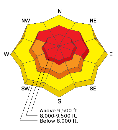
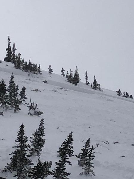
  • Yesterday a backcountry party had a very close call in the Brighton backcountry area called Figure 8 Hill. A skier triggered and was caught and carried in a reported 3' deep and 100' avalanche that broke near the ground into the old weak early season snow. It was not a full burial as first reported - the skier came to rest with his head sticking out of the snow, but he had suffered a dislocated shoulder. Their report to us is HERE. Thanks; best for a speedy recovery. Figure 8 Hill is a steep northeast facing run at 9900'. Pic at the bottom.
  • West Monitor - a natural cornice fall triggered a repeater avalanche nearly 2' deep and 80' wide on this steep northeast facing slope at 10,000'.
  • Dutch Draw - a skier reportedly triggered a 1-2' deep and 150' wide avalanche on a steep northeast facing slope at 10,000'.
Confused on locations? Check out longtime UAC boardmember Steve Achelis's Wasatch Backcountry Skiing maps (better yet get the app).
Ad
Avalanche Problem #1
Persistent Weak Layer
Type
Location
Likelihood
Size
Description
When people ask - "What will it take to continue to trigger avalanches into the weak old snow near the ground?" The answer is, simply, "This." This is nearly 3" of snow-water-equivalent (24-30" of snow so far) along with moderate to strong winds. Furthermore, any new storm snow or wind slab avalanche may in turn step down into this older snow layering (especially previously avalanched slopes), creating a much more dangerous slide. These are unmanageable avalanches and are not to be trifled with. Collapsing and cracking may or may not be evident but avalanches are likely to be triggered at a distance and be 3-4' deep and a couple hundred feet wide.
Click on the button below for more details on how this layer formed and where you can find it.
TRAVEL ADVICE: Stay off of and out from underneath steep northwest to east facing terrain.
Avalanche Problem #2
New Snow
Type
Location
Likelihood
Size
Description
Wind drifts and new snow avalanches will be sensitive to provocation on many slopes at the mid and upper elevations with a natural avalanche cycle likely during periods of heavier snowfall this morning. These wind slab and storm snow avalanches may step down to early December crusts and may be up to 2-3' deep or more. Collapsing and cracking are sure signs of instability. Avoid the growing cornices along the ridgelines.
TRAVEL ADVICE: During periods of heavy snowfall and strong winds, natural avalanches are likely. Anticipate this for today and stay off of and out from beneath steep slopes of all aspects. Ask yourself Am I in an avalanche runout zone?
Additional Information
Avalanche Rescue is the real deal. You must feel completely confident that you can pull off an avalanche rescue if things go wrong today. Even this may not save the day as roughly 1/4-1/3 of all fatalities are due to traumatic injury. If there is an avalanche accident, CALL 911 and say this is a backcountry emergency. But make no mistake - YOU NEED TO PULL OFF THE RESCUE, AND MOST LIKELY YOU HAVE ONLY 15-20 MINUTES TO DO SO.
KNOW THAT RESCUE TEAMS ASSUME A GREAT DEAL OF RISK in coming in to help injured or avalanched parties. AS ALWAYS, PLEASE OBEY CLOSURES AND UPHILL POLICY RESTRICTIONS AS INDICATED BY SKI AREAS AND UDOT.
General Announcements
This information does not apply to developed ski areas or highways where avalanche control is normally done. This forecast is from the U.S.D.A. Forest Service, which is solely responsible for its content. This forecast describes general avalanche conditions and local variations always occur.