Forecast for the Salt Lake Area Mountains

Greg Gagne
Issued by Greg Gagne for
Friday, December 13, 2019
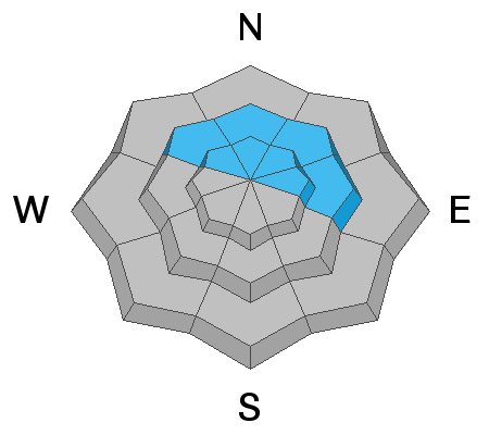
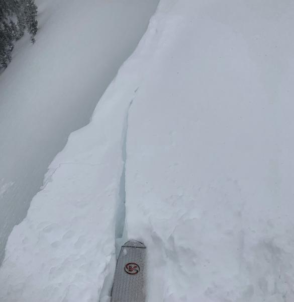
The avalanche danger is HIGH on northerly and east-facing slopes at the upper elevations and CONSIDERABLE on these aspects at the mid-elevations where a persistent weak layer of snow exists 3-4 deeply. Storm snow and strong winds have rapidly overloaded this weak layer, creating dangerous avalanche conditions on these slopes.

The avalanche danger is CONSIDERABLE on upper elevation aspects facing west through south and southeast at the upper elevations, as well as the mid-elevations, where sensitive storm snow and wind drifts can be found.

At low elevations, a Moderate avalanche hazard exists.

The key to safe riding today is to simply avoid being on or underneath any slopes 30 degrees or steeper. Fortunately, the dense snow provides excellent riding conditions on low-angled, wind-sheltered terrain.
Low
Moderate
Considerable
High
Extreme
Learn how to read the forecast here
Special Announcements
Thanks to the generous support of our Utah ski resorts and Ski Utah, we have discount lift tickets available. All proceeds support the UAC. Get your tickets HERE.

Consider taking an avalanche class, there are many different options. Click on the Education menu for a full list of classes from the UAC and other providers. Check out the Know Before You Go eLearning program for free, online, avalanche classes.

Deer Valley is performing explosives work as they prepare opening Empire Canyon. Please stay clear of this area.
Weather and Snow
Current Weather
- Mountain temperatures are in the upper teens through mid 20's F.
- Winds are westerly and strong. Averaging in the teens and 20's mph at the mid elevations, with gusts in the 30's and 40's mph. Even stronger gusts along upper elevation ridgelines, including 86 mph at 11,000'.
- Snowfall totals are 4-6" overnight, with 24-hour totals of 12-18" containing 1.5-2" of water. Much of the overnight snowfall contains dense graupel.
For today, snowfall should wind down by late morning, with an additional 2-4" of snow expected by the early afternoon. Temperatures will range through the 20's F. Winds are westerly and will remain strong. At the mid elevations winds will average in the teens with gusts in the 30's mph. Along upper elevation ridgelines winds will average in the 20's mph with gusts in the 50's mph. Snowfall should begin to increase later today, bringing periods of heavy snowfall overnight into Saturday, along with continued strong winds.

Our Week in Review - summarizing the significant weather and avalanche events of the past week - can be found here.
For a complete weather briefing view the video at the bottom of the page under "Additional Info".
Recent Avalanches
There was one report of a human-triggered avalanche on Thursday - this occurred on a southeast aspect on Country Lane (aka Suicide Chute) on Mt. Superior. A rider was caught and briefly carried, with the slide taking out the entire chute and running to the apron. The slope was likely wind-loaded. (Observation). The storm snow was reactive during periods of heavier precipitation yesterday afternoon with sensitive soft slabs failing within the storm snow.
On Wednesday, control work at a Cottonwood resort resulted in three avalanches that failed in the faceted snow down near the ground. These avalanches were on northerly aspects and occurred on slopes that had slid previously (known as repeaters) but left weak snow in place, providing a weak layer for continued avalanching once more snow filled in on the slope.
Ad
Avalanche Problem #1
Persistent Weak Layer
Type
Location
Likelihood
Size
Description
We continued to have avalanches this past week failing in the persistent weak layer of faceted snow down near the ground. This has included control work at resorts in unopened terrain, as well as riders remotely-triggering slides from a distance. These slides are 2-3' deep and up to 200' wide.
This weak snow can be found on mid and upper elevation slopes facing northwest through north and east. Over the past 24 hours, we have stressed this weak layer with an additional 12-18" of snow containing nearly 2" of water as well as strong winds depositing wind-drifted snow on these slopes.
Click on the button below for more details on how this layer formed and where you can find it.
It's quite simple - stay off of and out from underneath slopes steeper than 30 degrees on slopes facing northwest through north and east. Avalanches can be triggered from below, and the dense snow and wind slabs can allow a rider to get well onto a slope before it avalanches. Any avalanches on these slopes may be 3-4' deep and several hundred feet wide.
Avalanche Problem #2
Wind Drifted Snow
Type
Location
Likelihood
Size
Description
Strong westerly winds at the mid and upper elevations will create dense wind slabs. Although these fresh drifts will mostly be found on leeward aspects facing north through southeast, strong winds can often be channeled through terrain features and you may find wind drifts on any aspect. Cornices may be sensitive and can break back much further than expected. Avoid being on any slopes steeper than 30 degrees that are wind-loaded. The photo below shows cracking in wind-drifted snow - the best evidence of sensitive wind drifts and cornices. (Mark White)
Avalanche Problem #3
New Snow
Type
Location
Likelihood
Size
Description
You can expect to find sensitive storm snow at the mid and upper elevations, especially during any period of higher precipitation. Storm snow instabilities typically diminish quickly (ie a few hours), however the existing snowpack that the storm snow landed upon had developed weaknesses at the surface, including surface hoar and near-surface facets, and this may allow the storm snow to remain sensitive much longer. Yesterday, a long-time observer was finding a poor bond with the old snow surface in Millcreek (observation) and in upper Little Cottonwood I was finding preserved near-surface facets underneath the few inches of storm snow that had fallen (observation). We will need additional field work to determine if these buried weak layers are reactive and how widespread they have been preserved.
Additional Information
General Announcements
This information does not apply to developed ski areas or highways where avalanche control is normally done. This forecast is from the U.S.D.A. Forest Service, which is solely responsible for its content. This forecast describes general avalanche conditions and local variations always occur.