Observation Date
12/12/2019
Observer Name
Greg Gagne
Region
Salt Lake » Little Cottonwood Canyon
Location Name or Route
Upper LCC Perimeter
Weather
Sky
Overcast
Precipitation
Light Snowfall
Wind Direction
West
Wind Speed
Moderate
Snow Characteristics
New Snow Depth
2"
New Snow Density
High
Snow Surface Conditions
Powder
Snow Characteristics Comments
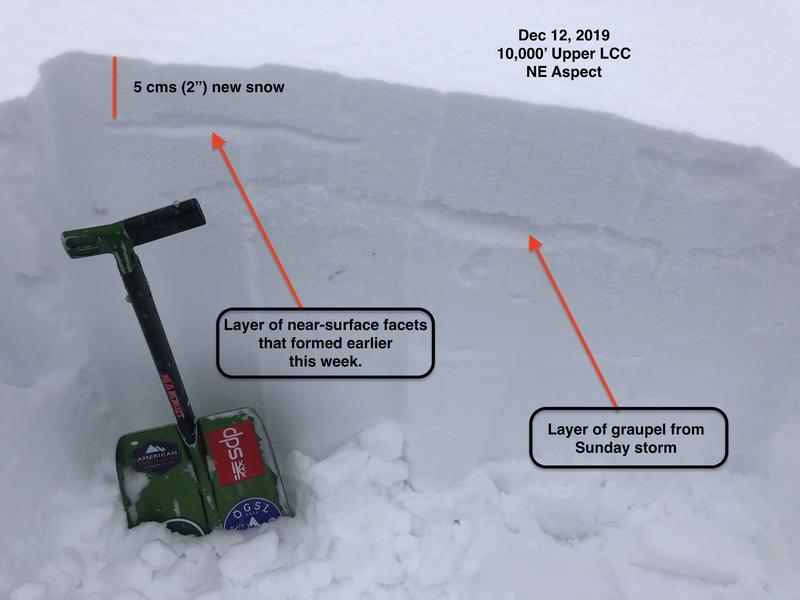
5 cms (2") of dense new snow by 8 am.
Red Flags
Red Flags
Heavy Snowfall
Wind Loading
Poor Snowpack Structure
Red Flags Comments
Snowfall rate was beginning to increase when I left the canyon late morning, along with an increase in winds. Poor snowpack structure refers to the persistent weak layer found on mid and upper elevation NW, N, NE, and E aspects.
Avalanche Problem #1
Problem
Persistent Weak Layer
Trend
Increasing Danger
Problem #1 Comments
Not much new to add to this other than the expected heavy snowfall and winds forecasted for the next few days are likely going to make these deeper weak layers reactive once again. Quite simply, no one should venture on or below slopes steeper than 30 degrees on aspects facing NW, N, NE, and E.
Avalanche Problem #2
Problem
New Snow
Trend
Increasing Danger
Problem #2 Comments
When I was out today I was focusing on weaknesses found on the old snow surface where a layer of surface hoar and near-surface facets had formed over the past few days. (Mark White has some nice photos of
surface hoar development he observed on Tuesday in Broads Fork.) Whereas I was unable to find any preserved surface hoar in upper Big and Little Cottonwood, I did notice preserved near-surface facets underneath the small amounts of new storm snow. There wasn't enough of a slab on top to make this layer reactive, but with more snow and wind in the forecast, the new snow/old snow interface may be a reactive layer for avalanching.
Comments
In addition to finding the layer of preserved near-surface facets, there is also some layering of graupel in the top 20-30 cms (8-12") of the snowpack from this past Sunday's storm. I was getting clean shears at this interface using a shovel tilt test. The photo below shows the relative position of the near-surface facets and graupel underneath the 5 cms that fell early Thursday.
If wind and snowfall totals verify, easy to imagine the hazard rising to Considerable on all aspects at the mid and upper elevations.
Today's Observed Danger Rating
Considerable
Tomorrows Estimated Danger Rating
Considerable