Forecast for the Salt Lake Area Mountains

Dave Kelly
Issued by Dave Kelly for
Tuesday, December 13, 2022
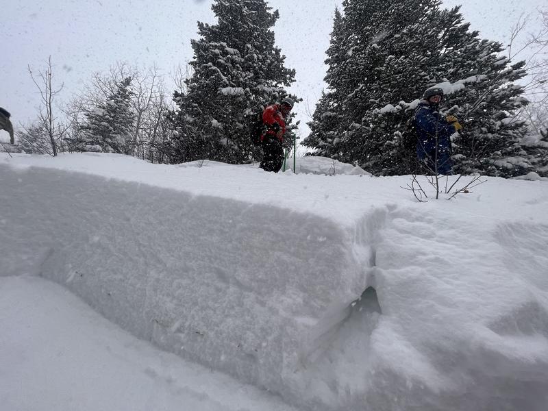
The avalanche danger is CONSIDERABLE on northwest through east aspects where natural and human-triggered avalanches may break 1-4' deep and 200' wide, failing on a persistent weak layer of faceted snow. The avalanche danger is MODERATE on west-south-southeast aspects.

The north facing slopes that are harboring old weak faceted snow surfaces are not to be messed with.

HEADS UP - Please make sure any friends or family members who may be walking a dog, snowshoeing, etc. are aware that they can trigger avalanches on small steep slopes.
Low
Moderate
Considerable
High
Extreme
Learn how to read the forecast here
Weather and Snow
The National Weather Service has issued a Winter Storm Warning that will last through Tuesday at 5:00 pm.

Currently there is light snow in the mountains with temperatures in the single digits F at the highest elevations and mid teens F at the trailheads. Winds are westerly in the mid teens MPH gusting to the low 30's MPH.
Today 3-6" of low density snow will fall and temperatures will be 15-19 F. Winds at the 9000' ridgelines will blow from the northwest 15 gusting to 25 MPH and at the 11,000' ridgelines 25 gusting to 35 MPH. Unsettled weather and light snow should continue through Thursday. There is great skiing and riding to be had on lower angle slopes and it looks like it will continue through the week.
With the addition of yesterday's snow and more snow overnight storm totals are up to:
  • Cottonwood Canyons- 15-30" .8-1.75" water
  • Park City- 13-18" .50-1"water
Recent Avalanches
Yesterday there were a number of avalanches reported from the backcountry. The majority of these avalanches occurred on north-east facing slopes where the buried persistent weak layer is present. These avalanches broke up to 2' deep and 150' wide.

There were a few avalanches that occurred under 8000' on north aspects in Daly Canyon near Park City, and in Summit Park near Parley's Summit. These lower elevation north facing aspects are areas where we have had avalanche accidents in the past. There is enough snow above summer hiking trails where people could get caught and buried in terrain traps.
Check out all the avalanches HERE.
Photo- Crown of Avalanche in Daly Canyon east aspect 7500'
Unstable test slopes in Bear Trap Fork.
If you see an avalanche please report it HERE.
Ad
Avalanche Problem #1
Persistent Weak Layer
Type
Location
Likelihood
Size
Description
There is plenty of weak sugary faceted snow (persistent weak layer) scattered on almost all aspects and elevations throughout the Wasatch Range. This persistent weak layer has now been buried under wind drifted snow in upper elevation terrain and capped by storm snow in the lower elevation wind protected areas.
In areas where the wind has loaded the slope, the slab could be anywhere from 1-4' feet deep and hard as a rock. We have dangerous avalanche conditions, and you can still trigger a season-ending slab avalanche failing on a persistent weak layer. There is great skiing to be had on low angle slopes and I will be staying away from steep northwest-north-east facing slopes.
Avalanches are slightly less likely on solar aspects because of the presence of ice crusts. There is a MODERATE avalanche danger on west-south-southeast aspects. Keep any eye out for higher elevation south facing areas that may have weak faceted snow under a stiffer slab of new or wind drifted snow.

Avalanche Problem #2
New Snow
Type
Location
Likelihood
Size
Description
Expect to see loose dry avalanches on steeper facing terrain. I wouldn't be surprised to hear of long running sluffs in the new snow today.
Avalanche Problem #3
Wind Drifted Snow
Type
Location
Likelihood
Size
Description
Any wind slab avalanche that you trigger has the potential to step down into deeper weak layers in the snowpack.
Additional Information
Mark Staples has also written a season summary HERE.
Check out this forecast discussion.
General Announcements

This information does not apply to developed ski areas or highways where avalanche control is normally done. This forecast is from the U.S.D.A. Forest Service, which is solely responsible for its content. This forecast describes general avalanche conditions and local variations always occur.