Forecast for the Salt Lake Area Mountains

Nikki Champion
Issued by Nikki Champion for
Wednesday, December 11, 2019
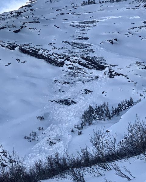
Today the avalanche danger is CONSIDERABLE on northerly and east-facing slopes at mid and upper elevations where a persistent weak layer of snow exists 2-4 feet deep.

The avalanche danger is MODERATE on southerly-facing and west-facing slopes at mid and upper elevations which don't have the persistent weak layer on the ground. On these aspects watch for signs of shallow slabs of wind drifted snow, and avoid them.

LOW avalanche danger exists at low elevations which continue to have generally safe avalanche conditions.
Low
Moderate
Considerable
High
Extreme
Learn how to read the forecast here
Special Announcements
Thanks to the generous support of our Utah ski resorts and Ski Utah, we have discount lift tickets available. All proceeds support the UAC. Get your tickets HERE.

Get one of these cool t-shirts to support the UAC and other avalanche centers across the U.S. INFO
Weather and Snow
This morning we have an inversion in the mountains, with temperatures in the mid-teens F at mid-elevations and mid-20s F at upper elevations. Westerly winds stayed moderate yesterday averaging 10-15 mph and gusting up to 30 mph at ridgelines.
Today a weak weather system will move through the Wasatch bringing warm temperatures in the mid to upper 20s F. Westerly winds will continue throughout the day averaging 10-15 mph and gusting up to 30 mph at ridgetops. This system could bring 2-4" of snow late this morning.
Beginning Thursday, a steady westerly & northwesterly flow with embedded disturbances will bring more snow and periods of increased winds through the weekend. This weekend should have fairly cold temperatures. Total new snow amounts by Sunday could be 1-2 feet.
Recent Avalanches
Yesterday, one ski area triggered several avalanches in the old, weak facets on high elevation, north-facing, steep rocky terrain that had not been opened or had received any explosive testing.
On Sunday, a skier triggered 3 slab avalanches on Square Top along the Park City Ridgeline. As he was escaping the first slide (several hundred feet wide), he triggered the second (20 ft wide) and then triggered the third (100 ft wide). Each of these broke in old, weak, faceted snow near the ground. These avalanches were about 20 inches deep and had avalanched during snowfall around Thanksgiving. On Saturday an avalanche on Peak 10,420 in Big Cottonwood Canyon that was triggered remotely
Monday, in Toledo Chute in Little Cottonwood Canyon, a skier triggered a soft slab avalanche in the new snow about a foot deep. Ski patrols continued to trigger many shallow, soft slab avalanches in the new snow generally less than a foot deep.
Yesterday two glide avalanches were reported in Broads Fork of Big Cottonwood Canyon on Bonkers and the Diving Board. Both avalanches were on a NE aspect between 9500-9700'. These are outlier events that typically don't happen until spring or under spring-like weather conditions. We don't understand glide avalanches very well and don't know why two occurred yesterday. What we do know is that these two slopes are ones that often produce glide avalanches in the spring. (photo M. White)
Ad
Avalanche Problem #1
Persistent Weak Layer
Type
Location
Likelihood
Size
Description
We still have the perfect recipe for a deep dangerous avalanche. This snow-pack needs a lot of time to heal. Any slope facing northerly or east at mid and upper elevations has weak old faceted snow on the ground and a dense 2-4 foot slab on top of it. Sunday's 6-12 inches of snow (0.8-1.57 inches of water) in combination with increased winds have added stress to this layer of facets and it will continue to be unstable moving into the next weather system.
Recent avalanches and collapsing are clear warning signs, avoid mid to upper elevation north-facing and east-facing terrain, or stay on slopes below 30 degrees with no slopes above, below or connected that have a slope angle above 30 degrees.
The photo below shows the common snowpack structure, weak, sugary facets with a dense slab on top.
There is good news, southerly facing terrain will continue to have fun riding conditions where this avalanche problem does not exist.
Avalanche Problem #2
Wind Drifted Snow
Type
Location
Likelihood
Size
Description
Yesterday's westerly winds blew 10-20 mph and gusted into the 30s. Sunday's new snow was transported by northerly winds early Monday morning and then by the westerly winds yesterday. We looked at the avalanche in Toledo Chute yesterday, and it appeared to be new snow that was likely wind-drifted. Look for signs of wind-blown snow which often looks rounded and smooth. Also, look for slopes that were scoured or eroded and consider where that snow was transported.
The simple strategy is to look for and avoid these slabs of freshly wind drifted snow on steep mid and upper elevation slopes.
Below is a video looking at the Toledo Chute avalanche and wind drifted snow.
General Announcements
This information does not apply to developed ski areas or highways where avalanche control is normally done. This forecast is from the U.S.D.A. Forest Service, which is solely responsible for its content. This forecast describes general avalanche conditions and local variations always occur.