Forecast for the Salt Lake Area Mountains

Mark Staples
Issued by Mark Staples for
Tuesday, December 10, 2019
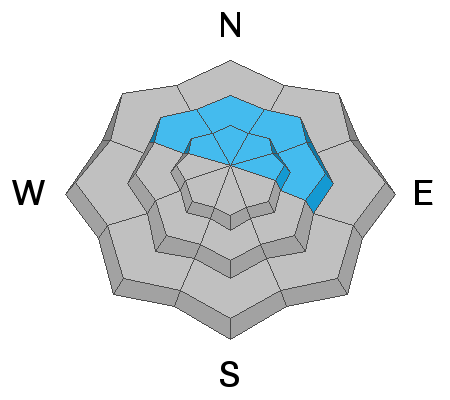
Today the existence of a persistent weak layer at the ground on northerly and east-facing slopes at mid and upper elevations makes the avalanche danger CONSIDERABLE. Recent avalanches and collapsing confirm this problem is still alive and waiting for a trigger to produce an avalanche 2-4 ft deep.

Southerly-facing and west-facing slopes at mid and upper elevations don't have this weak layer. The main avalanche problem to watch for is shallow slabs of wind drifted snow making the avalanche danger MODERATE.

Low elevations have generally safe avalanche conditions and a LOW avalanche danger.
Low
Moderate
Considerable
High
Extreme
Learn how to read the forecast here
Special Announcements
Thanks to the generous support of our Utah ski resorts and Ski Utah, we have discount lift tickets available. All proceeds support the UAC. Get your tickets HERE.

Get one of these cool t-shirts to support the UAC and other avalanche centers across the U.S. INFO
Weather and Snow
This morning under clear skies, temperatures dropped into the low to mid teens F. Winds were generally calm yesterday but increased this morning blowing westerly 10-15 mph and gusting 20-25 mph. Despite some sunshine yesterday the snow on south aspects remained dry.
Sunday's snowfall totaled 6-12 inches of snow (0.8-1.57 inches of water). Much of that storm had graupel and dense snow which has created fast, surfy riding conditions.
Today a ridge of high pressure will slowly move eastward over Utah bringing warm temperatures in the upper 20s and low 30s F. Westerly winds should decrease today and blow about 10 mph. Skies will have some clouds this morning but generally plenty of sunshine. Looking ahead, a small disturbance comes tomorrow but shouldn't produce much snow. Later this week and into the weekend, a steady westerly & northwesterly flow with embedded disturbances will bring more snow through the weekend. This weekend should have fairly cold temperatures.
Recent Avalanches
The snowpack continues to show signs of being unstable on slopes that had old snow on them prior to snowfall during the week of Thanksgiving.
Yesterday, one ski area in the Cottonwoods triggered an avalanche on a high elevation northeast-facing slope that broke in old, weak facets near the ground.
On Sunday, skier triggered a 3 slab avalanches on Square Top along the Park City Ridgeline. As he was escaping the first slide (several hundred feet wide), he triggered the second (20 ft wide), and then triggered the third (100 ft wide). Each of these broke in old, weak, faceted snow near the ground. These avalanches were about 20 inches deep and had avalanched during snowfall around Thanksgiving.
Nikki and I looked at an avalanche on Peak 10,420 in Big Cottonwood Canyon that was triggered remotely on Saturday. While in the area we experienced three collapses which should be treated a triggering or seeing a recent avalanche. Additionally, one ski patrol yesterday reported some collapsing.
Yesterday, in Toledo Chute in Little Cottonwood Canyon, a skier triggered a soft slab avalanche in the new snow about a foot deep. Ski patrols yesterday triggered many shallow, soft slab avalanches in the new snow generally less than a foot deep.
Ad
Avalanche Problem #1
Persistent Weak Layer
Type
Location
Likelihood
Size
Description
Yesterday Nikki and I went hunting for old, weak, faceted snow near the ground on Peak 10,420 in Big Cottonwood Canyon. We easily found it on any slope facing northerly or east at mid and upper elevations. This layer of facets has a dense slab 2-4 feet thick on top of it. The combination of new snow or wind loading every few days has added stress to this persistent weak layer and kept it unstable and dangerous.
Recent avalanches and collapsing are clear warning signs to avoid terrain where this problem exists. Drew and his partners yesterday skied into the Mill Creek drainage where they didn't see any obvious signs of instability; however, the simple existence of this layer kept them on low angle slopes.
Picture below shows terrain to avoid. If you look closely you may see a faint avalanche crown in the shade.
THE GOOD NEWS: Southerly facing terrain will have good turning and riding conditions today where you don't have to deal with this avalanche problem.
Avalanche Problem #2
Wind Drifted Snow
Type
Location
Likelihood
Size
Description
Sunday's new snow was transported by northerly winds early Monday morning and by westerly winds this morning. The avalanche in Toledo Chute appeared to be within the new snow that was likely wind-drifted. Simply look for signs of wind drifted snow which looks rounded and smooth. Also, look for slopes that were scoured or eroded and consider where that snow was transported. The simple strategy is to look for and avoid these slabs of freshly wind drifted snow at mid and upper elevations.
General Announcements
This information does not apply to developed ski areas or highways where avalanche control is normally done. This forecast is from the U.S.D.A. Forest Service, which is solely responsible for its content. This forecast describes general avalanche conditions and local variations always occur.