Join us at our 2nd Annual Blizzard Ball

Forecast for the Salt Lake Area Mountains

Drew Hardesty
Issued by Drew Hardesty on
Monday morning, November 9, 2020
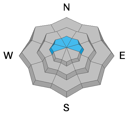
The avalanche danger will be more pronounced in the upper reaches of the Cottonwoods and Provo mountains where they received the most snow. Human triggered avalanches may be possible in localized wind drifted terrain, particularly on steep northerly facing slopes. Keep an eye out for sluffing in the steepest terrain.
REMEMBER two things:
1- The old adage - it there's enough snow to ride, there's enough snow to slide.
2- Traumatic injury due to the early season conditions is likely with any - even minor - avalanche incident.
We will be issuing intermittent updates and publishing backcountry observations as they arrive.
You can find these observations HERE.
Low
Moderate
Considerable
High
Extreme
Learn how to read the forecast here
Special Announcements
ALTA SKI AREA CLOSED TO ALL UPHILL TRAVEL FROM 4 PM TO 8 AM DAILY BEGINNING TUESDAY NOV. 10TH . THE ALBION BASIN SUMMER ROAD IS OPEN WITH ACCESS TO THE SUPREME AREA AND CATHERINES PASS BACKCOUNTRY CONDITIONS EXIST.

The 13th annual Utah Snow and Avalanche Workshop open session will be held virtually on Nov 10, 11, 12th from 630pm-9pm. We have a great lineup with something for everyone - beginners to experts.
Get more details on each session, and sign up HERE.

Covid and the Backcountry - Even in the backcountry and in parking lots, please follow CDC guidelines like limiting group size and keeping a distance of at least 6 feet from other people to protect yourself and others. More info HERE.
Taking risks - Be extra conservative to avoid the risk of accidents which can stress the capacity of our medical system.
Weather and Snow
WOW! Now this is a way to start the season. Rough storm totals are below. And....the weather pattern for storms still looks active.
Upper Little Cottonwood Canyon: 24-30" (2-2.4" Snow Water Equivalent SWE)
Upper Big Cottonwood Canyon: 12-16" (1-1.2" SWE) with about 12" in the mid-canyon Spruces lot at 7400'.
Park City Ridgeline: 12-14" (1-1.14" SWE)
Ogden area mountains: 10-14" (1.3"-1.75" SWE)
Provo area mountains: 13-16" (1.5-2" SWE)

The storm began midday Saturday and mostly petered out last night, a few hours before midnight. Accompanying southwest winds were in the moderate to strong category until Sunday morning as they lost steam and backed to the east and northeast.
Currently, mountain temperatures are in the mid teens with 11k temps in the single digits.
Winds are less than 15mph from the east and northeast.
I expect we see a flurry or two before the clouds start to thin by midday. Temps will be in the mid-to upper teens. Winds should remain on good behavior, but I am often skeptical about model guidance with east to northeast winds.

The weather pattern looks fairly active for the next couple of weeks with a weak storm mid-week and something perhaps more interesting over the weekend.
Recent Avalanches
Some sluffing reported in the new snow.
Ad
Avalanche Problem #1
New Snow
Type
Location
Likelihood
Size
Description
Sluffing can still be expected in the most recent 5-6% low density snow in the steepest terrain approaching 40° and steeper.
Avalanche Problem #2
Wind Drifted Snow
Type
Location
Likelihood
Size
Description
Lingering wind drifts may be found in the higher elevations from the moderate to strong southwest winds accompanying the early part of the storm. These drifts will likely be hidden by the newest low density storm snow. If you're looking to trigger wind slabs today, steep north facing terrain above 9500' and more widespread at 10,500' and 11,000' will be your ticket. (Baldy Chutes anyone?). This terrain should be avoided today.
Additional Information
There are a few things to remember:
  1. Hitting rocks and stumps is a real danger. Don't end your season before it starts with an injury from hitting one of these obstacles.
  2. Early season avalanches are a real possibility. It doesn't matter if you are hiking, hunting, skiing, etc., be prepared with rescue gear and a partner. Many people have died during early season snowstorms. Listen to our UAC podcast episode The Day of Madness in Little Cottonwood Canyon about a bad day in November 2011 when many avalanches were triggered resulting in a tragic fatality.
  3. Ski resorts all have different uphill travel policies. These closed resorts that allow uphill travel can be great places to get in a little skiing especially in you know of a rock-free slope, but it should be treated as backcountry terrain. We will soon have an up to date resource on all the ski resorts individual policies.
Until more snow begins to fall, there are plenty of resources available to begin thinking about the season today:
  1. Check out the free online avalanche course material and e-learning materials available.
  2. Start looking at weather patterns in areas you plan to ski this upcoming winter. A full list of mountain weather stations can be found HERE.
  3. Freshen up on how to read the forecast page.
  4. Look over all of your gear and make sure everything is in good, working order.
  5. Sign up for an avalanche class! Get it on the schedule early.
Bonus Material! Listen to our podcast on Early Season Essentials with Bo Torrey
General Announcements
This information does not apply to developed ski areas or highways where avalanche control is normally done. This forecast is from the U.S.D.A. Forest Service, which is solely responsible for its content. This forecast describes general avalanche conditions and local variations always occur.